Ocean Topics

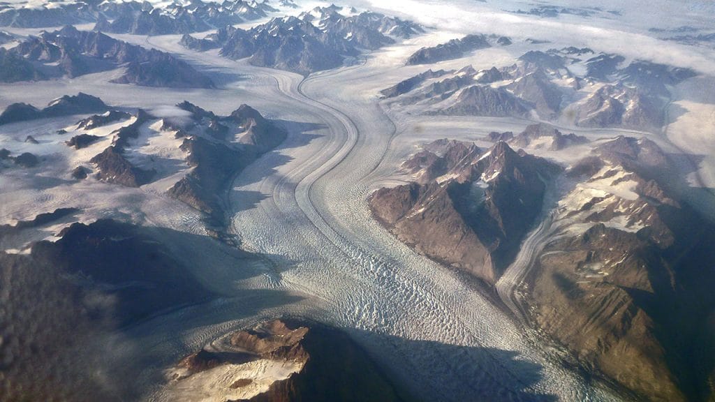
Greenland glaciers. (Photo by Chris Linder, Woods Hole Oceanographic Institution)
What are glaciers?
Ice accumulates over hundreds of thousands of years near the poles and at high altitudes, where more snow falls in winter than melts in summer. As a result, snow accumulates over time, with layers added year after year. Summer melt removes some of the snowpack; what remains compresses into pebbly bits of ice called firn. As new layers of snow are added year after year, the weight of the added layers of firn press down on those below, causing them to compact further. The ice undergoes a metamorphosis, reforming into ice crystals of various sizes. Because of this process, the US Geological Survey (USGS) classifies glacial ice as a mono-mineralic metamorphic rock. Naturally formed ice, because it is solid, is considered a mineral.
Over time, as long as snowfall continues to outpace losses, ice accumulates until the glacier begins to flow downhill under the forces of gravity and its own weight. These rivers of ice flow downhill at a truly glacial pace. It can take hundreds of years for ice that formed at the top to flow the full length of the glacier; the rate of movement depends on the thickness of the ice and the steepness of the slope down which it travels. Depending on conditions, glaciers can last for hundreds of thousands of years. The oldest glacier, in Antarctica, is thought to be almost one million years old.

What are ice sheets?
When glacial ice covers at least 50,000 square kilometers (20,000 square miles) of land, it is called an ice sheet. Earth is currently home to two ice sheets. One covers most of Greenland, the other most of Antarctica. Together they cover more than 10 million square kilometers of land and contain more than 99 percent of the freshwater ice on the planet. At the peak of the last Ice Age, ice sheets also covered much of Scandinavia and North America.
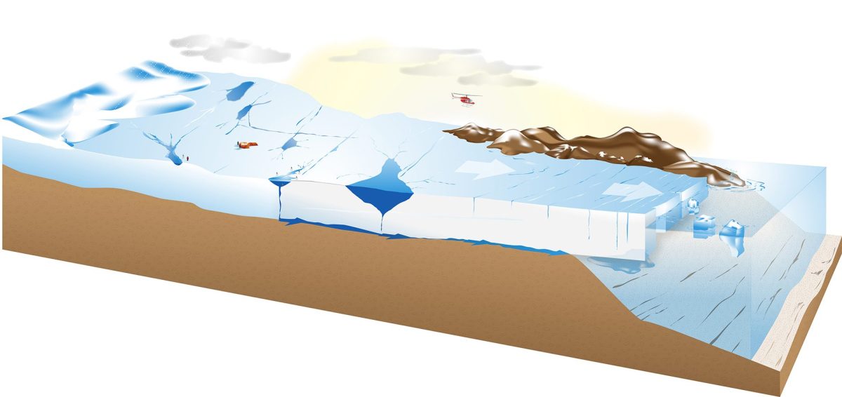
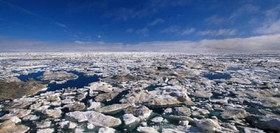
Ice sheets, which tend to be domed, can be several kilometers thick. Ice sheets also flow, but unlike glaciers, their ice moves out from the domed center. Although the sheet is solid, the ice behaves like a liquid, flowing over and around any land formations that block the way. The leading edge of the ice fractures as it moves outwards due to internal stress and drag over bedrock, creating crevasses and rifts than can lead to icebergs that calve, or break away, once the ice reaches the ocean.
Ice sheets typically flow to the sea, where they may form an ice shelf, ice tongue, or tidewater glacier. The rate of flow varies from one part of the ice sheet to another, and ice sheets can—and do—contain smaller glaciers. Flow can increase when meltwater seeps through cracks in the ice into the space between ice and land, where it can act as a lubricant to speed movement. Geothermal warming can similarly speed the flow of ice by melting the bottommost layer.

Why are they important?
Glaciers, particularly those located in high mountain ranges, provide essential freshwater to downstream populations, and the rivers they feed also power hydroelectric dams. Ice sheets store the vast majority of freshwater on the planet, but climate change is altering both snowfall patterns and the rate of melting, leading to overall losses of ice across the globe.
As ice melts and flows into the oceans, it raises sea level. As of 2014, sea level had risen 6.6 centimeters (2.6 inches) above 1993 levels, and continues to this day. This poses a problem for the hundreds of millions of people who live within five meters of the high tide line (approximately 10 percent of the global population). Unusually high tides and storm surges flood coastal communities much more frequently than they did 50 years ago, and as meltwater from ice sheets continues to contribute to sea level rise, these issues will only become more serious in coming years.
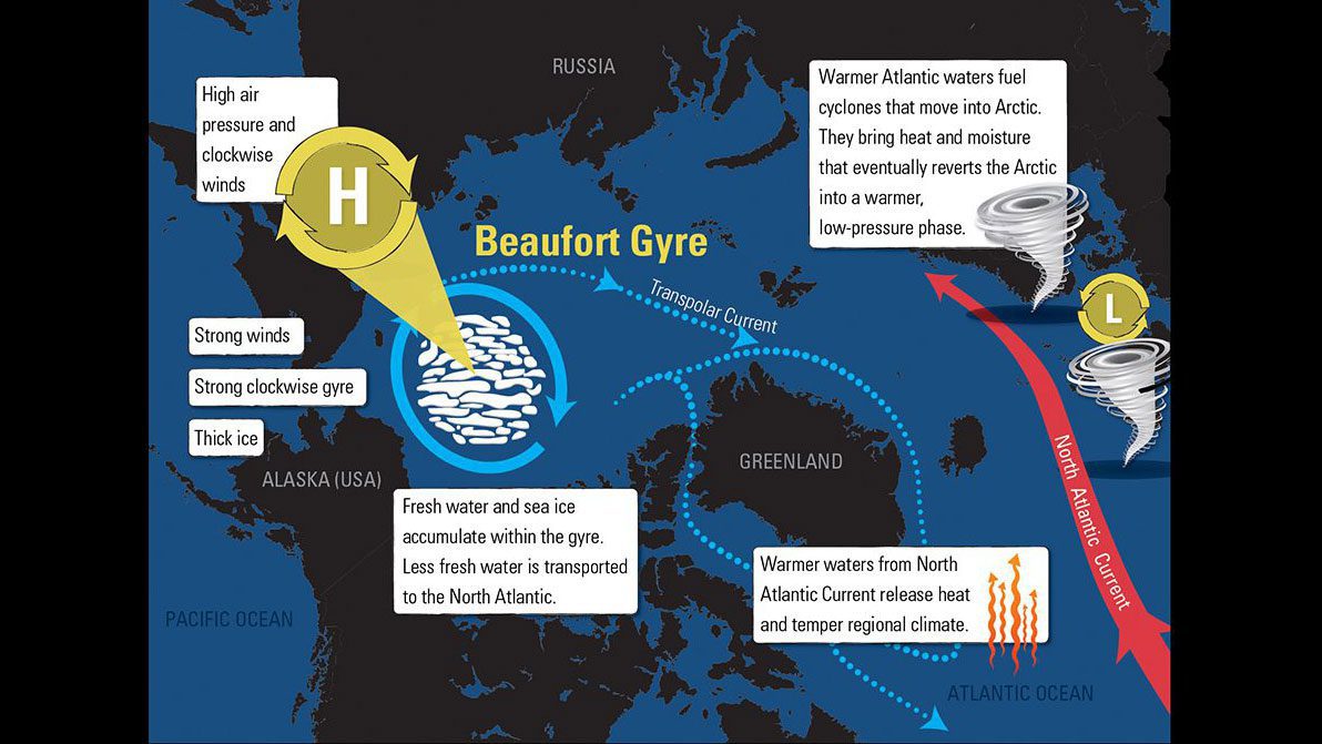
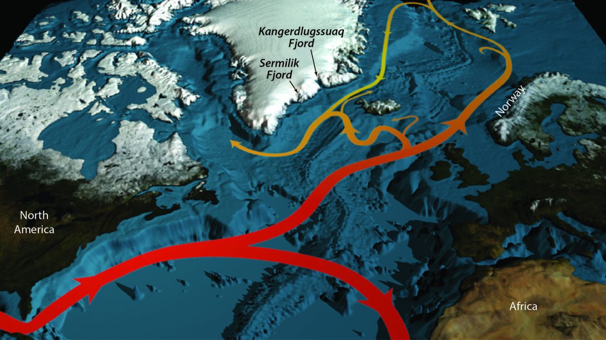
The Gulf Stream current, which brings warm water from the Caribbean across the Northern Atlantic to Iceland and Europe, is affected by the salinity of water. As meltwater from Greenland increases, it contributes large amounts of freshwater to the ocean’s surface. This could suppress the current, slowing the flow of water. The Gulf Stream exerts a strong influence on weather in Europe, and changes in ocean circulation would have large impact on the transfer of heat across the globe and resulting weather patterns.
How are scientists studying glaciers and ice sheets?
Researchers are monitoring glaciers and ice sheets in an effort to track changes in their structure and predict future losses of ice and the resulting impact it will have on sea level. Tracking something as massive as an ice sheet isn’t an easy task. Researchers can compare the outflow of water with snowfall accumulation to understand whether the ice is stable, growing, or declining. Or they can use satellites to estimate the total volume of ice, rate of movement, amount of melting, and overall changes in ice loss. As a result of these efforts, scientists have found that Greenland and Antarctica are losing as much as 120 gigatons of ice each year, and that rate is increasing over time.
Scientists also take ice cores to study Earth’s past climate. When snow falls and metamorphoses into ice, it traps tiny pockets of air that provide a glimpse of historical atmospheric conditions. Particulates in the ice can reveal volcanic eruptions, dust storms, and other events. As ice continues to melt at a faster pace, scientists are working quickly to obtain cores for future study before the source ice is gone.
Mark, B.G., et al. Glaciers as water resources. In: The High-Mountain Cryosphere (ed by C. Huggel, M. Carey, J.J. Clague, and A. Kääb). Cambridge University Press. September 5, 2015. doi: 10.10.17/CBO9781107588653.011.
Mark, B.G., et al. Glaciers as water resources. In: The High-Mountain Cryosphere (ed by C. Huggel, M. Carey, J.J. Clague, and A. Kääb). Cambridge University Press. September 5, 2015. doi: 10.10.17/CBO9781107588653.011.
National Ocean Service. Is sea level rising? https://oceanservice.noaa.gov/facts/sealevel.html
NASA Earth Observatory. Why does the Greenland Ice Sheet matter? https://earthobservatory.nasa.gov/features/Greenland/greenland_sidebar.php
National Snow & Ice Data Center. Quick Facts on Ice Sheets. https://nsidc.org/cryosphere/quickfacts/icesheets.html
National Snow & Ice Data Center. State of the Cryosphere. https://nsidc.org/cryosphere/sotc/ice_sheets.html
USGS. How old is glacier ice? https://www.usgs.gov/faqs/how-old-glacier-ice
USGS. Is glacier ice a type of rock? https://www.usgs.gov/faqs/glacier-ice-type-rock
All Topics on Glaciers & ice sheets
The many forms and shapes of ice
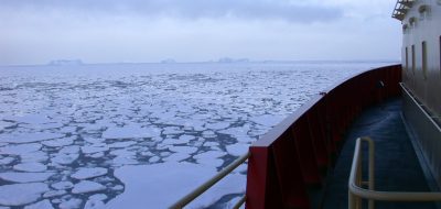
Ice comes in many forms and shapes. Icebergs can be as big as a house, while newly formed sea ice can be thin and rubbery like a piece of pizza dough.
 The many forms and shapes of ice