Scientists Find Trigger That Cracks Lakes
Fast-draining lakes atop Greenland ice sheet could accelerate sea level rise
In 2008, scientists documented for the first time a staggering phenomenon, long hidden from humanity, in the remote frozen expanse of Greenland.
Beneath a gleaming turquoise lake atop the ice sheet, a monstrous crack suddenly split the lakebed from edge to edge. Torrents of water surged through the crack—at times flowing out of the bottom of the lake faster than the water flowing over Niagara Falls. In less than two hours, the crack drained the entire lake, sending a deluge thousands of feet through the ice, all the way down to the bedrock.
The discovery was published in the journal Science by a research team led by Sarah Das and Mark Behn at Woods Hole Oceanographic Institution (WHOI) and Ian Joughin at the University of Washington. It stirred interest not only because it was dramatic, but also because it had dramatic implications for billions of people far removed from Greenland—in New York City, Bangladesh, and other coastal areas. The water that drained from the lake to the base of the ice sheet lubricates the interface between ice and rock, allowing the ice sheet to slide faster toward the coast. That accelerates the outflow of ice from land into the ocean, causing sea levels to rise faster.
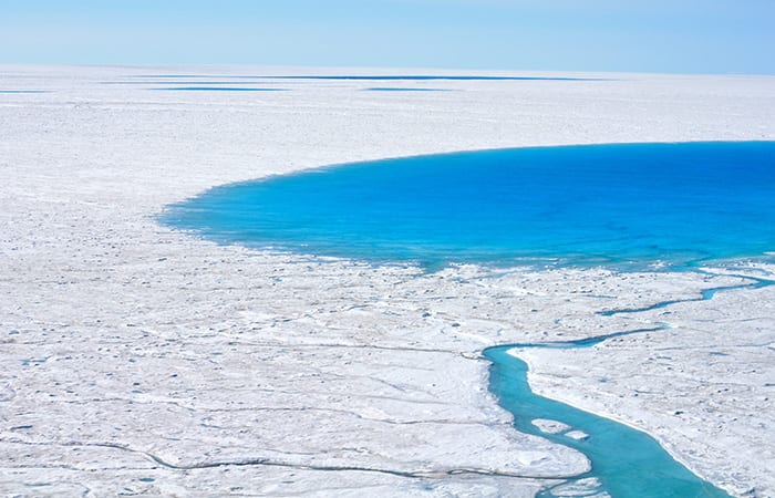
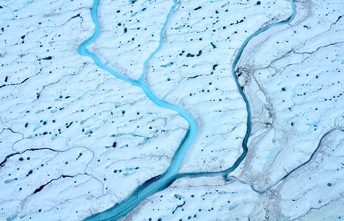
Thousands of these supraglacial lakes form on the ice sheet each spring as sunlight returns to Greenland after long dark winters and begins to melt snow and ice. The water streams into depressions in the ice sheet, filling them up to create the lakes. As Earth’s changing climate warms the region and creates more lakes, would that lead to more cracks, faster-flowing ice sheets, and faster-rising sea levels?
But in 2008, the scientists found only that these cracks, called hydrofractures, did occur. How they formed remained a mystery. Before scientists could predict more precisely how supraglacial lakes might affect sea level rise as climate conditions shift in the future, they needed to uncover the mechanisms that triggered the cracks.
Blue grass meets white ice
That 2008 Science paper also stirred the imagination of an undergraduate student at Wellesley College named Laura Stevens.
“I grew up in Kentucky, far away from ice and oceans,” she said. “But I’ve always been curious about anything that wasn’t in my back yard.”
She majored in geosciences, and for one class assignment, she was asked to hypothesize what the economy and climate of Kangerlussuaq, Greenland, would look like 100 years from now.
“So I spent some time researching Greenland and climate reports,” she said. “Then I kind of got into a late-night wormhole, like ‘Oh my gosh, there’s this whole field of people who go out and take measurements of ice.’ I said, ‘I’m good at physics and spatial problems. Maybe I can be good at this.’
“I found Sarah’s 2008 paper, and a couple other papers, and then was just encouraged by professors at Wellesley, none of whom were glaciologists. I graduated and came to WHOI as a summer student fellow. I just wanted to see what the place was like. I went to a couple talks—one was given by Mark about the Greenland lakes research, and another was given by Sarah. It was exciting work, and so I applied to the WHOI-MIT Joint Program. They said, ‘There’ll be a field campaign going on right when you get here. You’ll be going out to the ice.’ ”
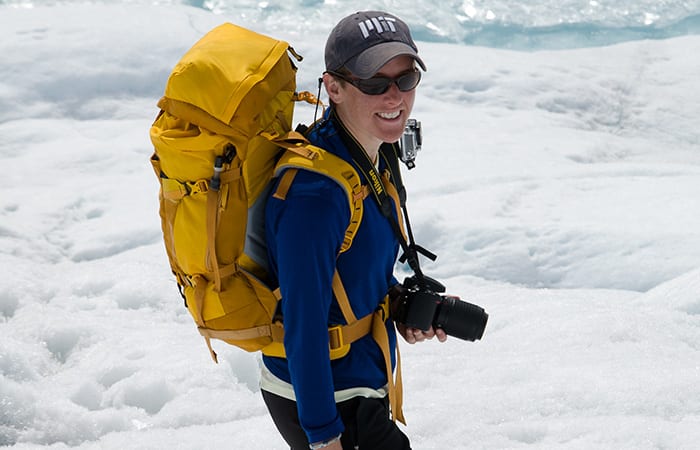
In her first year as a graduate student, Stevens spent the summer of 2013 camped near North Lake, the 1.5-mile-long lake in southwest Greenland where Das, Behn, and colleagues first documented large-scale cracks and lake drainages.
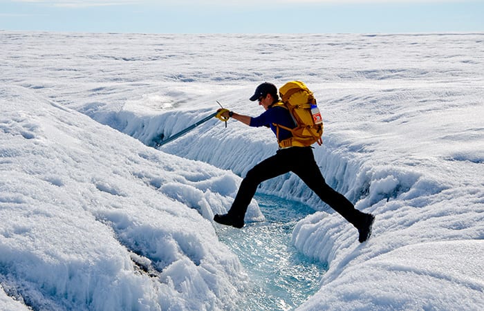
“It’s quite beautiful up there,” Stevens said. “It’s very flat, but there are lots of small stream networks every couple meters. It’s almost like you’re on a marsh in some way. There are a lot of stream channels, but instead of everything going in and out with the tides as in a marsh, on the ice sheet, you get a ‘high tide’ during the day, when ice melts and water flows downslope into the lakes. Then you get a ‘low tide’ at night when the water freezes again.
“So you can head out on a hike early in the morning, and the streams will all be pretty low, and then come back in the afternoon, and if it’s been a warm day, they’ll be a couple of feet higher. And you have to worry about getting yourself stuck.”
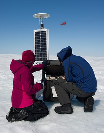
Thousands of supraglacial lakes form each spring and summer on top of the Greenland Ice Sheet as sunlight returns to the region. Many lakes disappear within hours when large cracks form below them, draining the lakes and sending torrents of water to the base of the ice sheet. To learn what triggers this phenomenon, a team of scientists installed a network of GPS units around a lake.
A spectrum of scientific skills
Scientists at first had theorized that the hydrofractures were caused by the sheer weight of the lake water applying pressure on the ice. But the theory broke down when they found large lakes with ample volumes that did not crack and drain.
“Those lakes remain on the surface and freeze from the top down during winter like a lake in New Hampshire,” Stevens said.
To try to determine why some lakes cracked and other didn’t, the research team deployed a network of 16 GPS units around North Lake. The GPS units move when the ice does, recording subtle movements of the ice before, during, and after three rapid lake drainages in the summers of 2011, 2012, and 2013.
Stevens became the focal point of a diverse team that interpreted the data to reconstruct what happened. The team included glaciologists Das, Joughin, and his graduate student David Shean; Behn, a geophysicist who ordinarily studies faults and rock deformation in Earth’s crust; and two experts in interpreting GPS data, Tom Herring at MIT and Matt King at the University of Tasmania. Also joining the team was a scientist who had never before studied glaciers, Jeff McGuire, a WHOI seismologist who studies earthquakes.
“We use GPS networks all the time to record movements of the Earth during earthquakes,” McGuire said. “The Greenland Ice Sheet is just a different type of solid crystals—ice instead of rock—which break due to stress. The hydrofractures in the ice are just another type of fault.”
Never before had such a dense array of GPS units been deployed on an ice sheet to collect data on ice movements. But once that was achieved, methods used to analyze earthquakes and rock deformation could be adapted for ice and lake cracks.
“The beauty was that instead of waiting a long time for a fault perhaps to do something, everything on the ice happens in hours instead of years, and it happens every summer,” McGuire joked.
The GPS network recorded the sudden and momentous movements of the ice sheet surface when the lakebed cracked. It showed that portions of the ice sheet bed beneath the lake can slip up to a foot and a half. That is equivalent to the movement caused by a magnitude-5.5 earthquake.
Stress buildup
Stevens was lead author of the study, which was published June 4, 2015, in the prestigious scientific journal Nature. The GPS data showed that in the 6 to 12 hours before the lake cracked and drained, the ice around the lake moved upward and slipped horizontally.
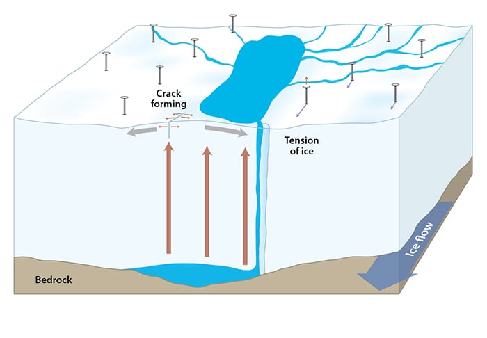
The scientists theorize that meltwater had begun to drain through a nearby system of moulins, or vertical conduits through the ice, which connected the surface to the base of the ice sheet. This accumulating water eventually created a bulge between the bedrock and the base of the ice, which floated the entire ice sheet. That exerted tension at the surface, underneath the lake. The stress built up until it was relieved by a sudden large crack in the ice below the lake.
“In some ways, ice behaves like Silly Putty,” Stevens said. “If you push up on it slowly, it will stretch; if you do it with enough force, it will crack. Ordinarily, pressure at the ice sheet surface is directed into the lake basin, compressing the ice together. But if you push up on the ice sheet and create a dome instead of a bowl, you get tension that stretches the ice surface apart. You change the stress state of the surface ice from compressional to tensional, which promotes crack formation.”
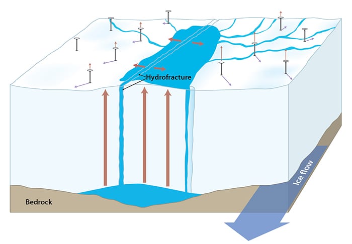
Once the tension initiates the crack, the volume of water in the lake does play a critical role. It surges into the opening with thunderous force, widening and extending the crack, and keeping it filled with water all the way to base of the thick ice sheet.
“You need both conditions—tension to initiate the crack and the large volume of water to amplify it—for hydrofractures to form,” Stevens said. The key finding of the study is that without the former, even large supraglacial lakes will retain their water.
Discovering this new trigger mechanism changes the equation, because the trigger is less likely to occur at lakes at higher elevations on the ice sheet—even when those lakes are large. Stevens explained that the ice sheet further inland is thicker and moves more slowly. The ice deeper down flows more viscously, dampening impacts on the surface topography. That results in a flatter surface where fewer lake basins and fissures form in the ice. Fewer fissures means less water leakage to the base, which reduces bulging that increases surface stresses.
“None of us could do everything that was needed for this study,” McGuire said. “But that’s the strength of the WHOI-MIT Joint Program. We have a long history of having smart energetic students who nucleate collaborations that lead to things that wouldn’t otherwise happen.”
Only after the research was finished and accepted for publication did Stevens begin to realize how rare it is for a graduate student to be lead author on a paper published in Nature. “If feels a little like, ‘Oh, did I hit a walk-off home run?’ ”
On a mobile device?
Illustrations by Jack Cook, Woods Hole Oceanographic Institution
On to the next question
A little more than halfway toward her Ph.D. degree, Stevens has her sights on another half of the lake drainage story: How does all the water from lake drainages make its way along the bottom of the ice sheet? She has forged a new collaboration with Oxford University scientist Ian Hewitt, who has done extensive work modeling the hydrodynamic plumbing system in the difficult-to–access realm beneath the ice sheets.
“We don’t know much about basic hydrology beneath the ice sheet, especially what happens right after a lake drainage,” Stevens said. Water may form a thin film and spread out at the interface of bedrock and ice sheet. A lot of water might provide enough energy to create a network of channels within the ice. As one scientist who reviewed the Nature paper commented, “Ice sheets may be more like Swiss cheese that we realize.”
“The GPS network measurements from the days to weeks following lake drainages will be useful for tackling these questions,” Stevens said.
Hewitt has developed a computer model of ice sheet hydrology from the terminus of a glacier at the coast to 50 kilometers inland. Stevens wants to collaborate to make a higher-resolution model that zooms into a 10-kilometer region, the area around one lake.
“Satellite images show that multiple lakes can drain in a cluster over a couple of days,” Stevens said. “What impact does that have on the system?”
Stevens said she has enjoyed the camaraderie in the subfield of glaciology. “It’s similar to people who go on oceanographic expeditions. They get to know many other people in their field at other institutions. The same thing happens in glaciology. You’re just on a sea of ice as opposed to water.”
The research was funded by the National Science Foundation’s Office of Polar Programs, the National Aeronautics and Space Administration’s Cryospheric Sciences Program, and an NSF Graduate Research Fellowship.
From the Series
Slideshow
Slideshow
 After long dark winters, sunlight returns to Greenland each spring and heat melts ice. The meltwater streams into depressions in the ice to form large supraglacial lakes. (Laura Stevens, Woods Hole Oceanographic Institution)
- Thousands of supraglacial lakes form each summer on top of the Greenland Ice Sheet. Scientists had found that the lakes can drain completely within hours, sending torrents of water to the base of the ice sheet. That lubricates the interface between rock and ice, which allows the ice sheet to flow faster to the ocean. When more ice is discharged into the ocean, sea levels rise faster. (Laura Stevens, Woods Hole Oceanographic Institution)
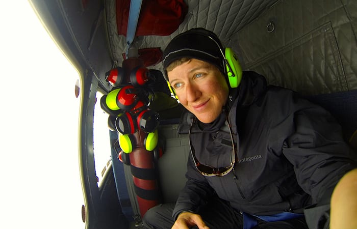
- To study supraglacial lakes, scientists over the last several summers have helicoptered atop the Greenland ice sheet to set up a research camp. Laura Stevens, a graduate student in the MIT-WHOI Joint Program in Oceanography, joined the team on the ice in 2013. (Laura Stevens, Woods Hole Oceanographic Institution)
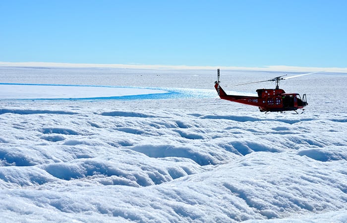
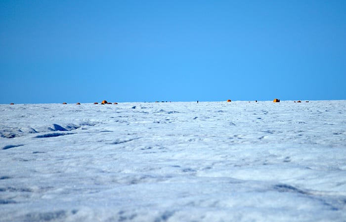
- A helicopter brings researchers and equipment to a supraglacial lake atop the Greenland Ice Sheet. If you look closely in the background, you can see the tents of the scientists’ ice camp. (Laura Stevens, Woods Hole Oceanographic Institution)
- Over the last several years, researchers have established camps each summer on the Greenland Ice Sheet to study supraglacial lakes. (Laura Stevens, Woods Hole Oceanographic Institution)
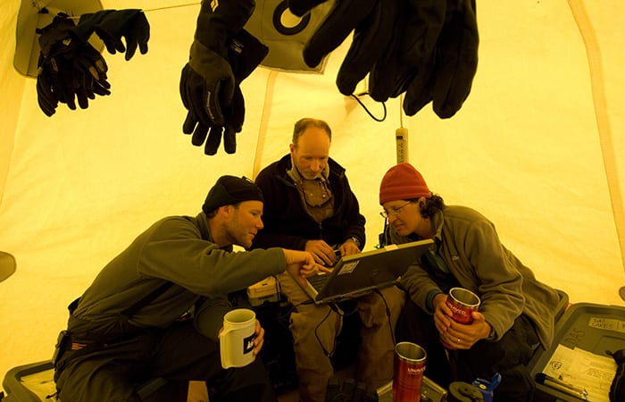
- In a tent in their ice camp, Woods Hole Oceanographic Institution scientists Mark Behn (left) and Sarah Das (right), and Ian Joughlin from the University of Washington, plan research strategy. (Chris Linder, Woods Hole Oceanograhic Institution)
- To find out what triggers the sudden draining of supraglacial lakes, WHOI scientits Sarah Das (left) and Mark Behn and colleagues deployed a dense network of GPS units around a lake to record movements of the ice before, during, and after sudden drainage events. (© 2012 Chris Linder)
- The scientists found that water spilled into moulins, or vertical conduits through the ice, and was transported to the base of the ice sheet. This accumulating water eventually created a bulge between the bedrock and the base of the ice, which floated the entire ice sheet. That exerted tension at the surface, underneath the lake. The stress built up until it was relieved by a sudden large crack in the ice below the lake. (Ian Joughin, University of Washington)
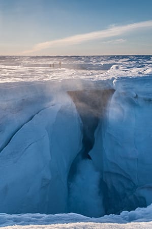
- Water pours into a seemingly bottomless moulin on the ice sheet. But water eventually does reach a bottom: the bedrock below the ice. (Chris Linder, Woods Hole Oceanograhic Institution)
- Graduate student Laura Stevens was lead author of a new study that identified a surprising trigger mechanism that causes large cracks to split open the bottoms of supraglacial lakes. The study was published in the prestigious scientific journal Nature. (Sarah Das, Woods Hole Oceanographic Institution)
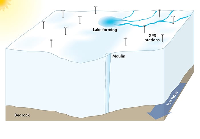
The process starts when the returning sun begins to melt snow and ice into water that pools in depressions in the ice sheet to form lakes. Depressions can form at the ice surface as the ice sheet flows slowly forward over depressions in the bedrock. Moulins are conduits that connect the surface to the base of the ice sheet thousands of feet below.
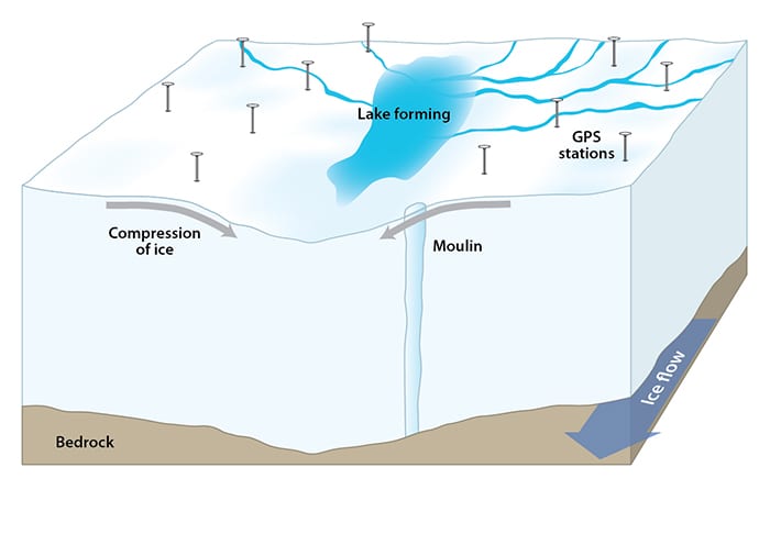
(Illustration by Jack Cook, Woods Hole Oceanographic Institution)The depression directs the flow of ice downward, compressing ice on either side together at the bottom of the depression. As melting increases, more streams feed the expanding lake.
(Illustration by Jack Cook, Woods Hole Oceanographic Institution)- An outflow stream from the lake spills water into the moulin, which transports it to the base of the ice sheet. (Illustration by Jack Cook, Woods Hole Oceanographic Institution)
Water slowly accumulates between the bedrock and the base of the ice sheet. It eventually creates a bulge that jacks up the entire ice sheet. That creates tension that overcomes the compressional forces. The ice begins to stretch apart at the surface. The water also lubricates the interface between ice and rock, allowing the ice sheet to slide faster toward the coast. GPS receivers record the ice moving upward and forward.
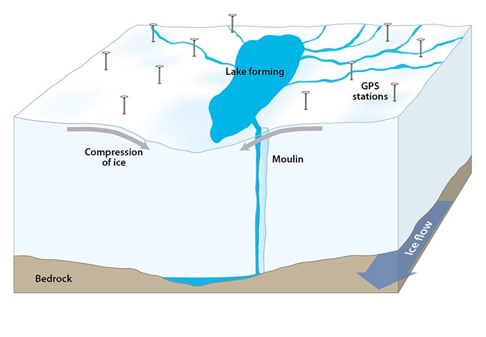
(Illustration by Jack Cook, Woods Hole Oceanographic Institution)The tensional stress builds up until it is relieved by a sudden large crack in the ice that extends below the lake. The huge volume of water in the lake surges into the opening, widening and extending it, and keeping it filled with water all the way to base of the ice sheet.
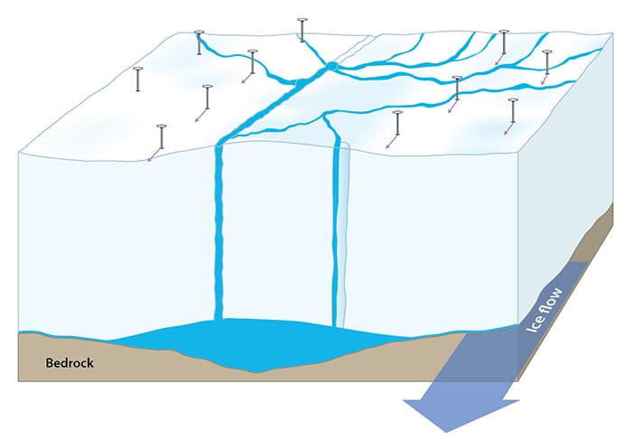
(Illustration by Jack Cook, Woods Hole Oceanographic Institution)These cracks, called hydrofractures, drain the entire lake within an hour or two. Water flows out of the lake bottom faster than the water goes over Niagara Falls. The influx of water at the base of the ice sheet causes the ice sheet to slide faster toward the coast. That accelerates the outflow of ice from land to sea and causes sea levels to rise faster.
(Illustration by Jack Cook, Woods Hole Oceanographic Institution)
Video
Related Articles
Featured Researchers
See Also
- Crack! A Lake Atop Greenland Disappears Oceanus magazine
- Getting to the Bottom of Greenland Ice Oceanus magazine
- Polar Discovery Expedition to Greenland's glaciers
- MIT-WHOI Joint Program in Oceanography
- Mark Behn's Homepage
- Sarah Das's Homepage
- Jeff McGuire's Homepage

