Global Observatories and Arrays
With drifters, floats, arrays of buoys and moorings, and novel communications systems (acoustic modems and satellite relays), researchers are examining ocean-wide processes.
Argo
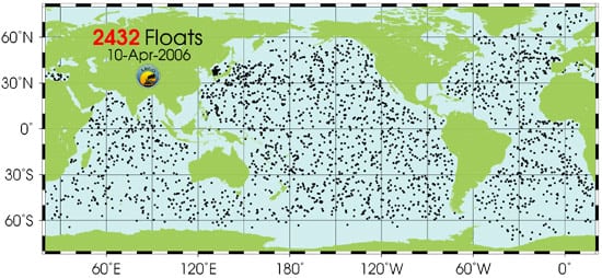
Argo is a global array of 3,000 free-drifting profiling floats that measures the temperature and salinity of the upper 2000 meters of the ocean. This allows, for the first time, continuous monitoring of the temperature, salinity, and velocity of the upper ocean, with all data being relayed and made publicly available within hours after collection. The name Argo was chosen to emphasize the strong complementary relationship of the global float array with the Jason satellite altimeter mission.
» Visit website
» Read an article from Oceanus magazine about the Argo system
» Read an article from Oceanus magazine about Argo floats
OceanSITES: Taking the Pulse of the Global Ocean
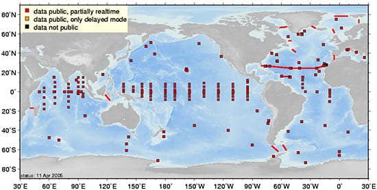
OceanSITES is a worldwide system of long-term, deepwater reference stations measuring dozens of variables and monitoring the full depth of the ocean from air-sea interactions down to 5,000 meters. Since 1999, the international OceanSITES science team has shared both data and costs in order to capitalize on the enormous potential of these moorings. The growing network now consists of about 30 surface and 30 subsurface arrays. Satellite telemetry enables near real-time access to OceanSITES data by scientists and the public. OceanSITES moorings are an integral part of the Global Ocean Observing System. They complement satellite imagery and ARGO float data by adding the dimensions of time and depth.
» Visit website
New Millenium Observatory (NeMO)
Led by NOAA's Pacific Marine Environmental Laboratory, NeMO is a project to establish a multi-year observatory at an active underwater volcano along the Juan de Fuca ridge. In order to examine the relationships between volcanic events, the chemistry of seafloor hotsprings, and the biologic communities that depend on them, NeMO will be established on Axial seamount, site of a volcanic eruption in January 1998.
» Visit website
GOOS - Global Ocean Observing System (GOOS)
Organized by the United Nations Educational, Scientific, and Cultural Organization (UNESCO), GOOS is a global system for collecting observations, modelling results, and analyses of marine data to support operational services worldwide. GOOS will provide descriptions of the present state of the oceans, including living resources; continuous forecasts of future conditions; and the basic information needed for predictions of climate change.
» Visit website
GEOSS -- Global Earth Observation System of Systems
In 2005, 61 countries agreed to a 10-year plan to revolutionize the understanding of Earth and how it works. GEOSS is envisioned as a large national and international cooperative effort to bring together existing and new hardware and software and to make the environmental data and information compatible.
» Visit website
ION - International Ocean Network
ION was established in June 1993 to facilitate international cooperation in the development of ocean-bottom observatories. This association--affiliated with the International Union of Geodesy and Geophysics--was formed to foster synergies among different disciplines and to facilitate cooperation in the development of ocean observing systems. Its goals include harmonizing ocean observing systems to allow for shared maintenance, development of common plans for the use of international resources, timely exchange of data, and coordination of siting plans.
» Visit website
Past and continuing programs
WOCE - World Ocean Circulation Experiment
Part of the World Climate Research Programme, WOCE combined resources from nearly 30 countries to observe poorly-understood but important physical processes and make unprecedented in situ and satellite observations of the global ocean between 1990 and 2002. The diverse WOCE data sets will serve as a unique resource for climate researchers and marine scientists for decades to come.
» Visit WOCE data site
TAO - Tropical Ocean Atmosphere program
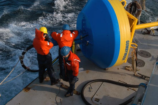
The TAO array consists of approximately 70 moorings in the Tropical Pacific Ocean, telemetering oceanographic and meteorological data to shore in real-time via the Argos satellite system. The array is a major component of the El Niño/Southern Oscillation (ENSO) Observing System, the Global Climate Observing System (GCOS), and the Global Ocean Observing System (GOOS). The array is primarily supported by the United States (National Oceanic and Atmospheric Administration) and Japan (Japan Agency for Marine-earth Science and TEChnology), with additional contributions from France.
» Visit website


