FAQs
Q. How big is TowCam?
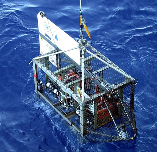
A. Flying the TowCam requires concentration, as the system weighs nearly 1,300 pounds (585 kilograms) in water. It is approximately the size and shape of a refrigerator tipped on its side.
Q. How many pictures can it take?
TowCam can take about 1,800 high-resolution (3.3 megapixel), color photographs each time it is deployed. A new digital photo is snapped every 10 to 15 seconds.
Q. What platforms are needed for TowCam?
A. TowCam can be operated off a wide range of vessels, including smaller coastal vessels.The only requirement? A standard UNOLS 0.322” CTD coaxial cable and winch system. This must be available as the TowCam uses the data and power provided by the cable for the onboard SeaBird 25 CTD system.
Q. What materials comprise TowCam?
A. TowCam is made from non-corrosive materials including stainless steel and plastics. The plastic vertical tail fin is made from a 1-inch wide polyethylene sheet.
Q. What are the advantages of using TowCam?
A. TowCam provides very high quality digital imagery of seafloor terrains to 6,000 meters depth (19,685 feet) with the capability to collect rock/lava samples and water samples concurrently. It can be used as an effective survey tool in conjunction with other deep submergence vehicle operations. It has been used in conjunction with the vehicles Alvin, Jason2, ABE and for other standard oceanographic surveys. It is currently the only system of its kind in the world.
Q. How has TowCam been used?
A. Since completion of their construction in mid-2002, TowCam systems have been used successfully on 14 research cruises.The TowCams have been used for seafloor mapping and imaging that span the fields of marine geology, petrology, volcanology, biology, hydrothermal vent mapping, and climate change/deep-sea coral mapping.
The current TowCam systems have been used on NSF, NOAA (Ocean Exploration and NURP), and USGS funded programs in the North Atlantic (New England Seamounts), eastern Pacific (EPR, Galapagos Rift, Hess Deep), southwest Pacific Lau Basin cruise, off Papua New Guinea, in the Gulf of Mexico, and Gulf of Alaska.
They have also been used offshore Taiwan in a collaborative program with the National Taiwan University, as well as site-survey mapping off northern Iceland for the Icelandic Energy Authority.
TowCam is more than just a camera. Scientists use the system to collect materials from the seafloor. To date, TowCam has been used to collect over 300 samples of volcanic glass and numerous water samples. All this is in addition to recording approximately 280,000 deep-sea photographs.
Q. New Developments
A. Images from the High-Speed Data Link TowCam ARE viewable in real-time but one sees a low-resolution video image that has been transmitted up the CTD cable using the recently developed HSDL system in conjunction with the TowCam
system.
Images from the Fiber Optic TowCam ARE viewable in real time but requires the use of a fiber optic cable and traction winch. In this case, the high-resolution images are transmitted up the fiber optic cable because of its high band width.
Q. Disadvantages?
A. TowCam cannot be "steered" because it is towed behind a ship. Unless it is navigated using an acoustic relay transponder, the position of the TowCam can only be estimated to within about 50 meters (164 feet). However, this degree of positional uncertainty is quite adequate for many reconnaissance surveys and for imaging and sampling seafloor features displayed on high resolution bathymetric or sidescan sonar maps.
The images from the 'normal'' TowCam are not viewable in real-time. They have to be downloaded from the digital camera once the system is back on deck, a process that takes about 40 minutes.

