BIOMAPER-II
The BIo-Optical Multi-frequency Acoustical and Physical Environmental Recorder
What is BIOMAPER and why do we use it?
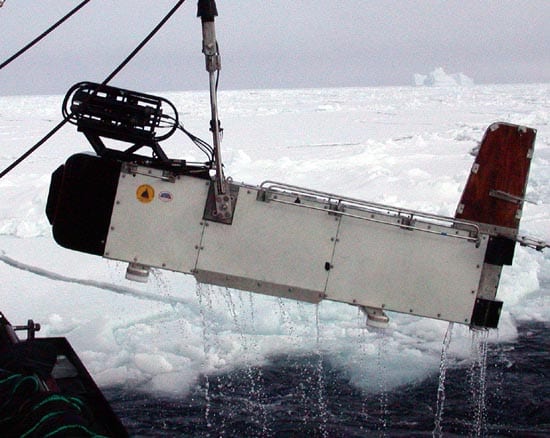
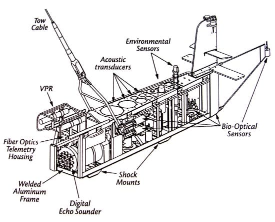
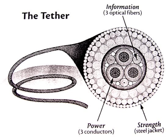
BIOMAPER is a set of sensors on a long aluminum frame that resembles the tail of a World War II airplane. A research vessel tows the instrument through the water on a specialized tow cable that sends power to the sensors and brings data back to the ship.
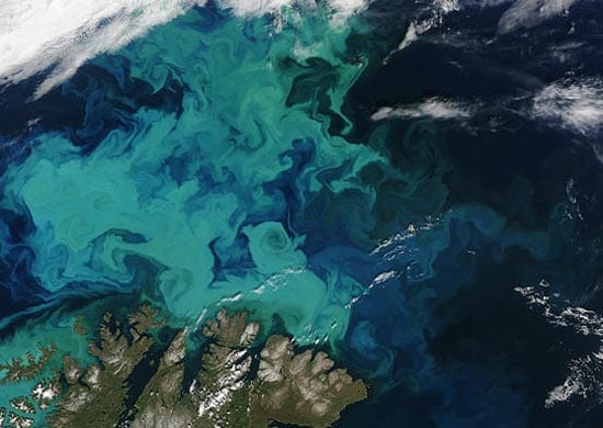
People use BIOMAPER to learn about phytoplankton and zooplankton over areas that are too large to study with the traditional net-and-microscope method. Whereas nets can sample areas up to about 5 meters (16 feet) on a side, BIOMAPER can record data from 500 meters (1,640 feet) or more of the water column at a time.
The instrument’s standard suite of sensors were chosen for studying plankton: a five-frequency sonar system, a video plankton recorder and an environmental sensor system (ESS, like the one on MOCNESS). The ESS measures water temperature, salinity, oxygen, chlorophyll and light levels. BIOMAPER also has room for attaching other instruments for specific uses.
The instrument's official name is BIOMAPER-II: the BIo-Optical Multi-frequency Acoustical and Physical Environmental Recorder. The Roman numeral II indicates that it's a redesign of the original BIOMAPER, a prototype that was invented and tested in the mid 1990s.
How big is it? How much does it weigh?
BIOMAPER is about 3.8 meters (12.5 feet) long, 85 cm (2.8 feet) tall and 55 cm (1.8 feet) wide. It weighs 907 kg (1 ton) in air, or 544 kg (1,200 pounds) in water.
BIOMAPER can be towed at speeds up to 18 km per hour (10 knots). When in "tow-yo" mode (see below), the top speed is 11 km per hour (6 knots) and the instrument can climb or fall at up to 10 meters (33 feet) per minute.
The sensors produce a combined 1 Gb of data per hour. BIOMAPER can operate indefinitely as long as there is power, data-storage space and a team of scientists to watch over the instrument panels. The standard sensor package requires 500 Watts of power, and the tow cable can deliver up to 2 kilowatts.
BIOMAPER is usually towed to within 2 meters (6.6 feet) of the surface (allowing light sensors to take reference readings) and can then descend to about 500 meters (1,640 feet). At normal settings, the range of the sonar extends about 250 meters (820 feet) above and below BIOMAPER's body.
How does BIOMAPER "see" plankton?
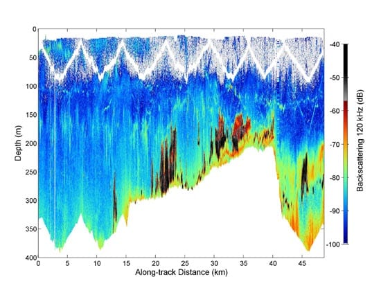
BIOMAPER records plankton over large areas by combining the strengths of sonar and video imaging. The sonar data pinpoints small objects in 1-meter increments through several hundred meters of the water column at a time.
As a check, the video plankton recorder mounted on the nose images a few centimeters of water at a time. Its detailed images allow scientists to identify the plankton with certainty. Meanwhile, the ESS collects physical data about the ocean water, helping scientists understand relationships between water conditions and ocean life.
As BIOMAPER tows through the water, five sonar units transmit sound waves upwards at 43, 120, 200, 420 and 1,000 kilohertz. Another five units transmit downward at the same frequencies. The different frequencies bounce off objects of different sizes. By timing the echoes the instrument calculates how large and how far away particles are.
There’s a lower limit to the size of particles that sonar can detect. For studying extremely small phytoplankton, biologists use other optical instruments fastened to bays in the aft of the instrument.
How is BIOMAPER operated?
Tail fins at the back of BIOMAPER keep the long body level and stop it from fishtailing. The instrument doesn't move by itself: As the research ship tows BIOMAPER through the water, a winch takes in or pays out cable to place the instrument at the desired depth.
A common towing pattern involves raising and lowering BIOMAPER through the water column as it travels. Nicknamed "tow-yoing," this course lets the video plankton recorder sample water at varied depths. The sonar system has enough range that, at least in coastal waters, it can usually sample the entire water column (to depths of about 500 meters or 1,650 feet).
What have we learned using BIOMAPER?
Since its first scientific dive in 1997, BIOMAPER has been used to study phytoplankton, zooplankton, and krill in the Gulf of Maine and the Antarctic Southern Ocean. By providing a wide-angle view of microscopic sea life, and measuring physical conditions simultaneously, BIOMAPER is helping scientists describe the habitats of the open ocean and count krill on a large scale.
What ships and equipment do you need to use BIOMAPER?
BIOMAPER can be towed by most research ships, as long as there is space for the instrument, its unique towing hardware and a control center.
Keeping BIOMAPER on a steady course even during high seas required inventing a specialized crane and winch system. The winch includes a slack tensioner that can reel in or pay out up to 12 meters (40 feet) of cable to compensate for surface waves.
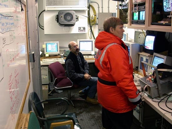
As data comes onboard through the specialized tow cable, it passes to computer and video displays in the BIOMAPER control room. Called a control van, this is a standard boxcar-sized shipping container. Three scientists normally staff the control van continuously while BIOMAPER is in the water: one watches the sonar results, one monitors the environmental sampling system and another watches the feed from the video plankton recorder.
BIOMAPER itself is stored in another shipping container that doubles as a weatherproof garage for scientists to install, repair and troubleshoot the instrument while at sea.
Advantages
The range of the sonar on BIOMAPER lets scientists see much more of the water column than they could using other methods. The sonar can capture some larger creatures (from several-centimeter krill to large fish) that can out-swim standard net tows.
By making long tows (some lasting more than a day) at speeds of 6 to 10 knots, the instrument can cover regions approaching the size of the Gulf of Maine.
Broad-scale sonar data verified by small-scale video "ground-truthing" and combined with physical ocean measurements help to paint a complete picture of life in the water column.
Limitations
BIOMAPER's arsenal of sensors does present a few practical limitations. Operators must be familiar with the details of all the instruments so they can diagnose and fix malfunctions or poor connections. And before each tow, each sensor has to be individually calibrated to make sure it's reporting accurately.
The 10 sonar units, the video plankton recorder, the instruments that make up the ESS and any additional instruments generate lots of data - about 1 Gb per hour. Analyzing and comparing readouts among sensors takes a lot of time and computing power.
The sonar units have a blind spot that extends 6 meters (21 feet) on either side of the BIOMAPER body (this is one reason for using a tow-yo survey pattern). This means that the video plankton recorder and the sonar are never sampling exactly the same water at the same time.
Sources
Peter Wiebe, Senior Scientist, Biology, WHOI. Research lab webpage
Heidi Sosik, Associate Scientist, Biology, WHOI. Research lab webpage
Foote, K. G. Acoustic scattering by marine organisms. p. 44-53 in J. H. Steele, K. K. Turekian and S. A. Thorpe (eds.), Encyclopedia of Ocean Science, Academic Press, San Diego, CA. (2001)
Warren, J. D. Estimating Gulf of Maine zooplankton distributions using multiple frequency acoustic, video and environmental data. Ph.D. thesis, MIT/WHOI Joint Program in Oceanography/Applied Ocean Science and Engineering, Cambridge/Woods Hole, MA. (2001)
Wiebe, P. H., and M. C. Benfield. From the Hensen net toward four-dimensional biological oceanography. Progress in Oceanography 56:7-136. (2003)
Wiebe, P. H., T. K. Stanton, C. H. Greene, M. C. Benfield, H. M. Sosik, T. C. Austin, J. D. Warren and T. Hammar. BIOMAPER-II: an integrated instrument platform for coupled biological and physical measurements in coastal and oceanic regimes. IEEE Journal of Oceanic Engineering 27:700-716. (2002)

