
Air-Sea Interaction Meteorology: The ASIMET System
What is ASIMET and why do we use it?
The ASIMET system is a set of seven very precise sensors that measure how energy and water move between the ocean and atmosphere. Those measurements are the raw materials for many calculations about climatic conditions. When climatologists build models of the Earth’s climate, they can use ASIMET measurements to check their predictions against reality.
ASIMET stands for Air-Sea Interaction METeorology. The system is used on ships and on buoys anchored in fixed locations in the ocean. In addition to the sensors, the system includes data recorders and a central data processor that sends information back to scientists by satellite.
Is that the same thing as measuring weather conditions?
No. Climate studies are on a different scale from weather studies. Climatologists are interested in understanding the long-term weather patterns that characterize regions of the Earth or periods of the Earth's history.
For example, weather forecasts predict rainstorms, whereas climate studies explain why monsoon seasons happen. Meteorologists explain how hurricanes form; climatologists study what makes them enter the Gulf of Mexico in some years or sweep up the East Coast in others.
How does ASIMET help study climate?
Understanding Earth’s climate boils down to understanding how the Sun’s energy moves heat and water around the planet and between ocean, atmosphere and land. For oceanographers to balance the checkbook, they need to follow at least three types of exchange, or flux, between air and sea:
- Heat flux, the movement of energy by two kinds of radiation, shortwave (light) and longwave (heat); plus direct contact between ocean and air (sensible heat); and evaporation or condensation (latent heat).
- Water flux, the balance between evaporation from the sea surface and precipitation back into the ocean.
- Momentum flux, the transfer of energy from the wind physically pushing against the water.
Measuring the fluxes directly, with a single sensor, isn't an option. Each flux must be calculated using precise values for several variables (about a dozen total variables for all three fluxes). The ASIMET system provides those variables at the necessary precision using seven sensors:
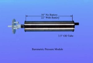
- Barometric pressure
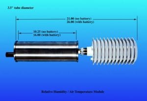
- Relative humidity and air temperature
- Sea surface temperature and salinity
- Longwave radiation
- Shortwave radiation
- Wind speed and direction
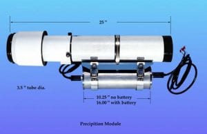
- Precipitation
See below for more information about each sensor.
What do the seven sensors look like?
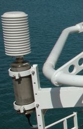
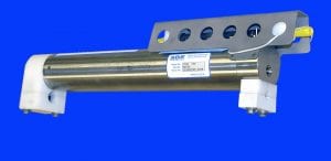
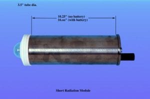
The seven sensors are individually housed in weatherproof titanium canisters, so they all look fairly similar to each other. The canisters are about 56 cm (22 inches) tall and 9 cm (3.5 inches) across. Only one sensor (sea surface temperature and salinity) goes in the water; the other six are mounted atop a buoy or high on a ship's bow mast.
Technical description of sensor housings.
ASIMET deployments carry two full systems of sensors, data handlers, satellite antennas and batteries. The duplication ensures there is a backup if one sensor goes wrong, and helps with calibrating the data as it comes in.
How do we get the data back?
The sensors record data once per minute onto a central data logger. Through the course of their deployment, they also send hourly averages back to researchers via satellite.
Do you need a special kind of buoy?
Over the years ASIMET instruments were placed on many kinds of buoys (see slideshow), but gradually engineers developed a preferred design.
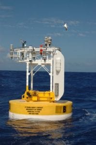
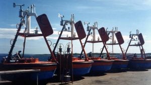
The buoy in use today is discus shaped and about 3 meters (10 feet) across. It is made of Surlyn foam, a spongy, buoyant fabric that gets wound up in a spool, a little like an Ace bandage. There's no hard shell; the buoy walls are foam, painted yellow and blue. Inside is a watertight metal well where the batteries and central data processor are stored.
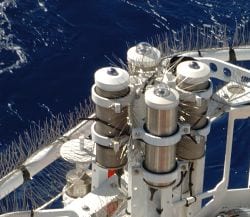
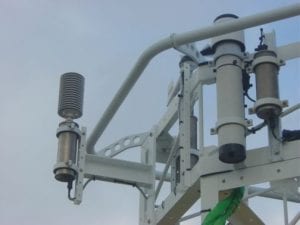
Atop the buoy is a metal tower supported by four columns. Around the top is a metal rim large enough to hold two sets of ASIMET instruments, plus a few additional sensors. A flat plastic vane on one of the tower columns catches the wind, pointing the front of the buoy and its instruments upwind. This minimizes disruption of air before it reaches the instruments.
Why put ASIMET sensors on both ships and buoys?
The two platforms have unique advantages. Buoys remain in a single location and build long, continuous records. Oceanographers carefully choose key locations important to global climate and deploy buoys there.
But buoys are expensive to build and deploy, and batteries last only about a year before the instruments must be recovered and redeployed. To bolster observations, oceanographers put ASIMET sensors on research vessels and on participating Volunteer Observing Ships (typically shipping or cruise vessels). As each ship traverses the ocean on routine courses, oceanographers get repeat measurements of climate variables.
Do the same instruments go on both ships and buoys?
The seven ASIMET sensors used on ships and buoys are identical, but there are minor differences in the power supply and satellite relay. Shipboard ASIMET systems use the ship's power supply instead of batteries, and they use a different satellite network to send data back to researchers. (Ships use the INMARSAT network; buoys use ARGOS.)
What is "burn-in"?
Burn-in refers to the process of installing and calibrating sensors before they go out to sea. Because the instruments are sensitive and need to deliver precise measurements, the burn-in process can last six weeks or more.
During burn-in, engineers first check that each sensor is installed correctly and reporting data. Next, they check accuracy by leaving the instruments outside for several weeks and comparing their readings. They also check that airflow over the instruments is not disturbed, and they adjust the instrument layout to minimize radio interference from the powerful ARGOS satellite transmitter.
Advantages
Precision. ASIMET sensors deliver precise readings suitable for detailed modeling of climate conditions. For example, the error in total heat flux is about 8 Watts per square meter. (The WHOI Upper Ocean Processes group has estimated individual sensor errors in their technical note #3, available for download here)
Reliability. Each deployment uses two sets of sensors that are calibrated both before and after their year at sea. In addition to transmitting home hourly averages, the system collects all the data for the year on Flash memory cards. These precautions mean that there are very few gaps in the data record.
Mobility. The sensors are modular, making them versatile enough to work on a variety of buoys and ships. If a sensor malfunctions, technicians can replace it without having to dismantle the entire ASIMET system. Individual sensors can be used separately on research projects that don't require the full ASIMET system.
Limitations
Most of the ASIMET system's limitations are imposed by the demanding ocean environment. This is particularly true on buoys, where systems must work perfectly for a year amid crashing waves, crusty salt spray and seabird poop.
ASIMET systems work well in the tropics and subtropics; at higher latitudes the instruments are prone to error from low sun angles, severe weather and low temperatures.
Radiation sensors work best when the sun is directly overhead. During rough seas, that's only part of the time. Motion sensors on the buoy help track how it rides the swells, but corrections are complicated.
Measuring wind direction is also complicated by the way the buoy swings to follow the wind. In light winds, temperature readings can be inflated, and this can bias humidity readings. Fixing these issues, or correcting for them, keeps ASIMET engineers busy between deployments.
At present, the ASIMET system does not measure carbon dioxide, a key ingredient in greenhouse warming. Sensors are under development and may be in use on ASIMET systems in the next three to five years.
Sources
Bob Weller, Senior Scientist, Physical Oceanography Department, Woods Hole Oceanographic Institution
Al Plueddeman, Associate Scientist with Tenure, Physical Oceanography Department, Woods Hole Oceanographic Institution
David Hosom, Principal Engineer, Physical Oceanography Department, Woods Hole Oceanographic Institution
Frank Bahr, Research Specialist, Physical Oceanography Department, Woods Hole Oceanographic Institution (Volunteer Observing Ships program)
George Tupper, Research Associate II, Physical Oceanography Department, Woods Hole Oceanographic Institution
Hosom, D. S., R. A. Weller, R. E. Payne and K. E. Prada. The IMET (improved meteorology) ship and buoy systems. Journal of Atmospheric and Oceanic Technology 12:527-540. (1995)
Colbo, K., and R. A. Weller. The accuracy of the IMET sensor package. Journal of Atmospheric and Oceanic Technology, submitted 2005.
WHOI Upper Ocean Processes Group, Technical Notes archive
AISMET Sensors

Multimedia
ASIMET Buoy Designs Over the Years (8)
In search of the perfect buoy design: rugged, roomy and aerodynamic, with low power requirements. Examples from ASIMET projects like NTAS, STRATUS, CLIMODE.
See Also
WHOI Upper Ocean Processes Group
Upper Ocean Processes home page, with links to current and completed projects and data archives
ASIMET Documentation Page
Technical specifications for ASIMET sensors and data handling. From the WHOI Design Group for Electronics.
Outposts in the Ocean
WHOI scientists are putting their eyes and ears on buoys in the middle of the ocean. From Oceanus magazine.
Reading in Greater Detail
The Upper Ocean Processes Group archive of technical notes and technical reports.