RAFOS Float
What is it and why do we use it?
The name RAFOS is the word SOFAR spelled backwards. SOFAR is an acronym for SOund Fixing And Ranging, which refers to the way these floats track the motion of water in the ocean. In large numbers, the floats can be used to map the mean currents over a wide area, and for statistical studies of dispersion and mixing. The acoustic tracking provides relatively high-resolution trajectories (with position fixes several times each day). This can be especially valuable in studies of eddies and boundary currents.
Some RAFOS floats are also called Deep Lagrangian Drifters, or DLDs.
How does it work?
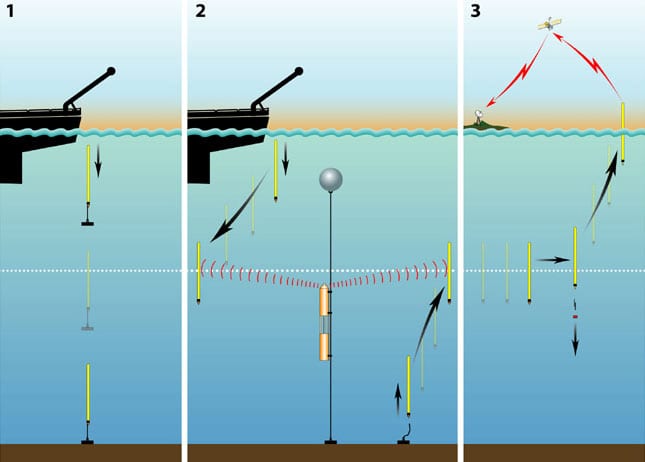
A drifting RAFOS float listens and records sound signals from stationary acoustic beacons. At the end of their pre-programmed mission, the floats drop their ballast weights, rise to the surface, and beam their data to orbiting satellites.
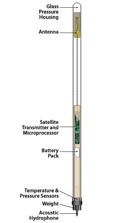
A RAFOS float weighs about 22 pounds (10 kilograms) and can be dropped over the side of a small boat by one person, although they are most commonly deployed from large oceanographic research vessels. The float's electronics are housed in a 6 and a half foot (two meter) glass tube. After assembly, the float is placed in a tank that can replicate the pressure of a given depth and is then ballasted with stainless steel weights that are attached at the bottom of the float.
A float's mission can be up to two years in duration. At the end of its mission, a pre-programmed command from the float's microprocessor releases the float's ballast weight. The float rises to the sea surface and beams the stored acoustic tracking data to two satellites, which pass the information to ground receiving stations, which then send it over the Internet to researchers' computers.
RAFOS floats can carry multiple sensors for measuring ocean properties, including pressure, temperature, and dissolved oxygen. They can be made "isopycnal", or density-following, so that they more accurately follow water parcels in regions where density surfaces are steeply sloped.
The predecessor to the RAFOS float, the SOFAR float (no longer used in large numbers but sometimes for special applications), made low-frequency signals periodically, and the signals were heard and recorded by moored listening stations. The backwards spelling of RAFOS refers to the reversed pathway of the sound in tracking these floats. In this case, the moored instruments make the sound, and the drifting floats listen and record the signals.
What platforms are needed?
The moored sound beacons used for tracking the RAFOS floats are usually deployed from oceanographic research vessels by trained mooring technicians. A special version of the float can be temporarily anchored to the ocean floor, and released from the anchor at a pre-set time. This allows for deployment in remote locations and at various times without the need for a research or other vessel.
Advantages and limitations?
Advantages:
The acoustic tracking provides high-resolution trajectories that are particularly valuable for resolving eddy motions and narrow boundary currents. As with other floats, Lagrangian instruments are useful for mapping currents over a large spatial area since they tend to spread out after deployment.
Disadvantages:
One disadvantage is that the scientist must wait until the end of the float mission, up to two years, for the data to be available. This is balanced by the advantage that by staying submerged, the floats can closely follow the motions of water particles for extended periods of time.
Sources:
A Mediterranean Undercurrent Seeding Experiment (AMUSE): Part I I : RAFOS Float Data Report May 1993 - March 1995 by Heather D. Hunt, Christine M. Wooding, Cynthia L. Chandler, and Amy S. Bower
The float's electronics are housed in a 6.5 foot (two meter) glass tube. Glass is used to house the instrument because it is relatively inexpensive and is extremely strong under pressure. The glass used for making RAFOS floats is about ? inch (7 mm) thick. An additional benefit of using glass is that the antenna can be contained inside the glass and still transmit data to the satellites.
An acoustic hydrophone 'listens' for sound signals in the ocean, recording the time the signals take place. These sounds can come from anything; ship noise or moored sound sources. The recorded signals are then compared, or correlated, with a signal pattern that matches that of the sound sources. The best matching signals from each listening cycle (varying from a few hours to a few days) are stored in the float?s memory, for transmission at mission's end.
The saved sound signal data are called times-of-arrival (TOAs), and by knowing the positions of the sound sources, the sound velocity in the ocean, and the lengths of time it took to hear each source, the float's position can be triangulated for each listening cycle. These float positions are used to reconstruct the float's journey along deep ocean currents.
The float is ballasted by a stainless steel weight. At the end of a mission, lasting from nine months to two years, the float drop its weight by sending an electrical pulse to a wire that burns and releases the weight. The now-buoyant float rises to the ocean surface and beams its data via the antennae to orbiting satellites.
After completing their drifting mission, these floats release a second weight and rise to the sea surface, where they transmit all their stored data to orbiting satellites which then re-broadcast the information to ground stations, as seen in picture three.
Most floats however begin their drifting missions immediately after deployment from a research vessel or ship of opportunity (shown in picture two). At the end of their drifting mission, they also transmit the data they collected to satellites that relay the information to the scientist.
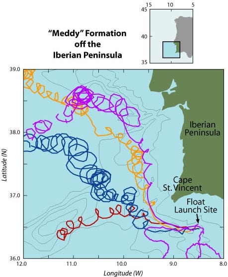
Near Cape St. Vincent, the floats started looping rapidly in the clockwise direction, with periods of rotation between two and seven days. This looping motion indicates that the floats were caught in the formation of new meddies near Cape St. Vincent. Some floats were trapped near the center of a meddy, and thus rotated more rapidly and with smaller loops, while others were entrained near the periphery of a meddy and thus rotated more slowly and with larger loops.
The floats are tracked underwater acoustically (as described elsewhere on this site). Sometimes acoustic transmissions are not heard by the float, resulting in a gap in the float's trajectory, when tracking was not possible. Although meddies had been discovered in the open Atlantic earlier, and recognized as important in the spreading of Mediterranean water in the Atlantic, these float trajectories represent the first observations of the formation of meddies. Knowing where meddies form is the first step to understanding why they form and how often. Based on these observations, it is now thought that the sharp corner in the coast at Cape St. Vincent is important in meddy formation. (Illustration by Jayne Doucette, WHOI)
See Also
NOAA Vent Programs Physical Oceanography
Outlines the use of RAFOS floats in understanding the transport of hydrothermal vent fluids
Read about her research projects and link to publications
University of Rhode Island and RAFOS
RAFOS Float Group Home Page
RAFOS Float Processing at Woods Hole Oceanographic Institution
RAFOS Users Forum and Float Processing


