
Research Highlights
Oceanus Magazine
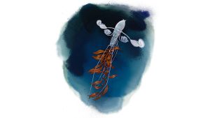
An upside-down swimming isopod shows how tightly we are connected to the deep ocean

With funding support from CMA CGM, ocean observations aboard Bermuda Container Line’s M/V Oleander now include a window into microscopic life
News Releases
American Association for the Advancement of Science welcomes 471 scientists and engineers in the class of 2024

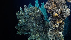
Woods Hole Oceanographic Institution among research groups that offer findings to support protection of species
Faster identification of fish sounds from acoustic recordings can improve research, conservation efforts
Researchers call for regional and context-specific approaches to these extreme events
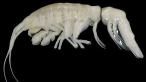
This crustacean is the first large, active predatory amphipod from these extreme depths.
News & Insights

WHOI’s Dennis McGillicuddy on why ocean life matters deeply to the Sunshine State

Are you an ocean lover? Go a little deeper with these courtship tips from beneath the waves!
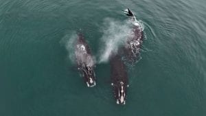
April 24 marks the first-ever Right Whale Day in Massachusetts. WHOI biologist and veterinarian Michael Moore recently met with the resident who brought this special recognition about– and explains why it’s important to raise awareness about the critically endangered North Atlantic right whale.
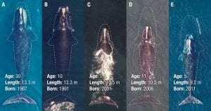
A report out this week in Current Biology reveal that critically endangered North Atlantic right whales are up to three feet shorter than 40 years ago. This startling conclusion reinforces what scientists have suspected: even when entanglements do not lead directly to the death of North Atlantic right whales, they can have lasting effects on the imperiled population that may now number less than 400 animals. Further, females that are entangled while nursing produce smaller calves.
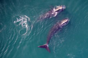
May 10, 2021 During a joint research trip on February 28 in Cape Cod Bay, Mass., WHOI whale trauma specialist Michael Moore, National Geographic photographer Brian Skerry, and scientists from New England Aquarium, witnessed a remarkable biological event: North…