Outposts in the Ocean
A global network of moored buoy observatories to track oceanic processes that affect our climate
January 2000 — Oceanographers and climatologists have something in common with politicians and stock market analysts: They are all trying to get a grasp on a complex, ever-shifting system.
To gauge the ebb and flow of public opinion, politicians today are constantly polling constituents. To track fluctuating financial markets, analysts receive a continual flurry of global economic data and information on companies and markets. For oceanographers and climatologists, one of the most urgent goals is unraveling the ocean’s crucial role in shaping our climate. To predict climate changes or extreme weather events that may have potential societal impacts, scientists desperately need the same sort of detailed, ongoing information that politicians and economists have to investigate their systems.
Specifically, oceanographers require long-term measurements to understand processes and changes that occur in the oceans over seasons, years, decades, or longer. Among the important climate questions oceanographers seek to answer are these: How does the ocean store and transport vast amounts of heat and fresh water around the globe? How do the ocean and atmosphere exchange heat, fresh water, and momentum? How are changes in ocean temperatures and salinity, ocean circulation, and climate all interrelated? Are long-term changes in the oceans naturally occurring, or are they the result of human activities, such as the buildup of greenhouse gases in the atmosphere?
Today, the world’s oceans are sparsely observed. Oceanographers lack the means to gather the fundamental measurements they need to examine their system—putting scientists in the position of working on mysteries without many essential clues.
But a major effort is under way to establish a Global Ocean Observing System (GOOS)—a worldwide network that would collect the vast, far-flung, ever-changing data necessary to understand the processes by which the oceans help create climate conditions. GOOS would combine a variety of instrumentation. It would include satellite systems providing global coverage of the ocean surface, flotillas of oceanographic instruments drifting throughout the oceans, and autonomous ocean observatories moored at strategic sites in the ocean.
Fixed observatories moored at key geographic sites around the globe are unique in this mix of instrumentation because they can provide highly detailed observations of atmospheric processes just above the sea surface, as well as oceanographic measurements from the seafloor to the sea surface. Measurements collected at fixed sites over long time periods are particularly important for oceanographers trying to understand air-sea interactions, as well as relatively slow-evolving oceanic processes.
In the past, a network of ocean weather stations (OWSs) provided a treasure trove of data for oceanographers and played an essential role in early efforts to build initial understanding of how the ocean changed over time and how it responded to, and in turn influenced, atmospheric changes. Primarily to guide transocean- voyaging aircraft after World War II, the US and four other countries established 13 sites in the North Atlantic and the Pacific Oceans (labeled alphabetically, starting with “A”) that were constantly occupied by ships. Planes would check in with ships to receive a position and weather data. Ship crews used weather balloons to gather air temperature, humidity, pressure, and wind direction and speed, and, while on site, they also collected a wealth of oceanographic measurements.
Unfortunately, by the 1970s satellites began to provide jet aircraft with the positioning and weather information they needed. The original reasons for maintaining the OWSs disappeared, and the program ended in 1981. The last remaining active station, OWS M off Norway, will end ship-based observations in 2000, and with it, the last vestige of a valuable system to collect long-term oceanographic data will disappear.
To fill the void in the future, we envision that among critical GOOS components will be a combination of free-drifting, or “Lagrangian,” platforms (such as the Argo floats described in the Argo Armada article ), and fixed, or “Eulerian,” platforms, such as surface and subsurface moorings. (The names derive from two 18th century mathematicians, Euler and Lagrange, who originated alternative ways of measuring fluid flow—past a fixed point and between two points.)
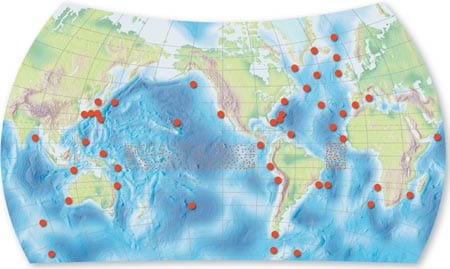
Eulerian observatories are not new to ocean sciences. They have been, and remain, one of the major elements in developing theoretical understanding of the oceans. In the tropics—motivated by the need to improve our ability to predict El NiÑo events—we have already constructed a new network of Eulerian observatories to obtain surface wind and upper ocean temperature observations. In the 1980s, the National Oceanic and Atmospheric Administration, the National Science Foundation, and international partners began to install the Tropical Atmosphere Ocean (TAO) array of more than 70 surface moorings in the equatorial Pacific. Completed in 1994, it provided the observations that helped give us advance warning of the powerful El NiÑo of 1997-98. The goal now is to build on TAO and occupy more sites across the world’s ocean to create a network of Global Eulerian Observatories (GEO).
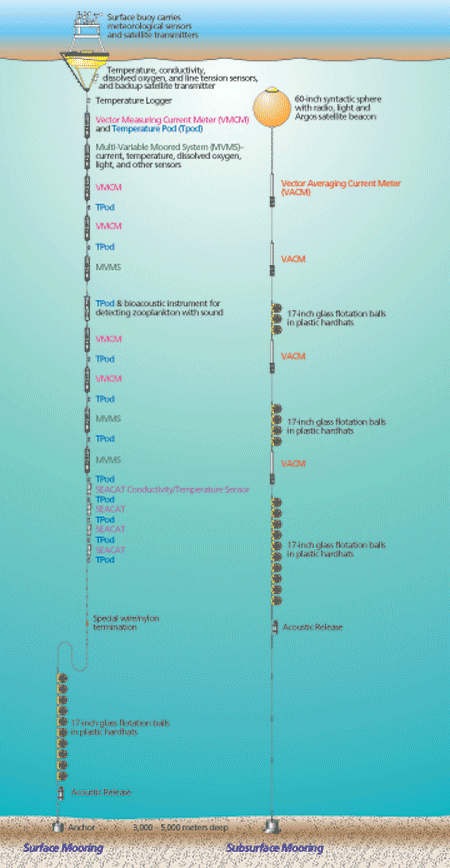
Such observatories come in two types. Since the 1960s, scientists have used subsurface moorings to observe ocean currents and water properties. These are instrumented cables, anchored to the seafloor and attached to buoyant floats, that reach upward toward, but not to, the sea surface. In contrast, surface moorings have surface floats with downward-hanging cables. Instruments along the submerged cables measure water temperature and salinity, and the speed and direction of currents. The surface floats additionally provide a platform for sensors that measure wind speed and direction, incoming shortwave radiation, incoming longwave radiation, relative humidity, air temperature, barometric pressure, and precipitation. The technology to make such meteorological observations, which was not even available until the 1970s, has improved significantly over the past 15 years, giving scientists the capacity to make highly reliable and accurate measurements.
Both types of mooring technologies have matured to the point where they can measure atmospheric and/or oceanic changes as frequently as once per minute and can take oceanographic measurements meter-by-meter in the water column. Both are now capable of sustained operation for long time periods.
Sensors on surface buoys now perform reliably for periods of six to 12 months. Data are both transmitted via satellite and recorded on board. A recent deployment of surface buoys in the Arabian Sea showed that they can perform well in severe environments. And it also demonstrated their ability to collect detailed measurements of previously undetected air-sea processes. Incorporating these previously overlooked processes into numerical weather prediction models will produce significantly more accurate forecasts.
Unlike surface moorings, which are exposed to winds, salt spray, surface wave motion, fouling by marine growth, and disturbances by vandals, subsurface moorings are subject to less stressful conditions and now routinely collect information for periods of up to two years without servicing. In the past 30 years WHOI alone has deployed almost 1,000 subsurface moorings in all parts of the world’s oceans. Information gathered from them has been used to begin to understand how the oceans change over space and time—with an emphasis on time scales of less than a year or so. In some parts of the ocean, such as the northwest North Atlantic, we have made enough measurements to be able to construct a three-dimensional “picture” of the ocean’s mean circulation and to estimate the speed and volume of waters transported by important currents.
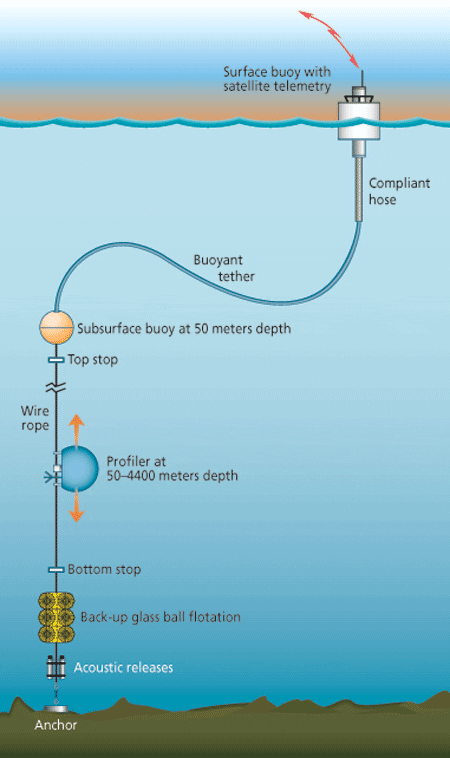
For subsurface moorings, a new class of observing system is approaching operational status: moored profiling instruments. These devices, fitted with a suite of oceanographic sensors, move vertically along conventional mooring cables, returning measurements of water properties and ocean currents at very closely spaced intervals throughout the water column. Using one mobile set of sensors versus many stationary, separate sensors not only reduces costs, it also removes the need to calibrate many different sensors to make sure their measurements are of comparable quality.
In each deployment, these instruments can make approximately 200 top-to-bottom ocean profiles— akin to those obtained from ships. Second-generation instruments may double this capacity. The addition of a bottom pressure sensor would grant the capacity to monitor fluctuations that are not dependent on depth (such as a tidal current, which has the same magnitude and direction throughout the water column), as well as fluctuations that do vary with depth (such as internal waves, moving beneath the surface and within the ocean, whose speed and direction may vary at different depths). The instruments can make such fine-scale observations of current velocities that scientists will be able to detect internal wave motions, as well as other flows that occur only infrequently. They will also be able to detect subtle variations in eddies— smaller-scale, episodically occurring currents that move contrary to main currents.
With these tools available, the international focus is now on identifying the strategically best GEO sites to investigate one or more of the four important scientific objectives listed below.
Direct measurements of ocean currents
At strategic sites, moored buoys can directly measure ocean currents flowing at the surface or down into the ocean’s interior. These currents redistribute heat and fresh water around the globe. In particular, the ocean and atmosphere help maintain the planet’s thermostatic balance by absorbing heat in the sun-drenched tropics and moving it toward Earth’s poles. Cooler (and denser) waters sink and flow back equatorward.
The details of these processes are not yet fully understood, yet they are the underpinnings of our climate system. We need, for example, long-term Eulerian observatories to measure the dense overflows of cold Norwegian Sea waters as they move south through the Denmark Straits and Faroe Bank Channel. We also need moored stations to measure variations in the poleward transport of warm water in currents, such as the Gulf Stream, that hug the western boundaries of continents.
Examining ‘water mass formation’
In some locations in the world ocean, surface waters become colder or saltier (and therefore denser) than surrounding waters and actually sink and flow into the ocean’s interior—a process known as water mass formation or transformation. This happens when the atmosphere cools the waters or where evaporation or sea ice formation leaves salt behind. Winds can also push surface waters together, and these convergent flows force surface waters downward.
Like a hand pushing down in a bathtub, the downward flow of waters from the surface to the interior of the ocean provides the propulsion to redistribute heat and fresh water throughout the ocean and around the world. In this way, the oceans can absorb heat from the atmosphere in the tropics, for example, and release it back to the atmosphere over the North Atlantic decades to hundreds of years later. Moored ocean observatories in key sites of water mass formation and/or transformation could observe the slow variations in the process—documenting the depth to which cold water sinks and chronicling changes in ocean heat and fresh water content over time.
Obtaining measurements of air-sea interactions
Meteorological data obtained above the sea surface would provide accurate measurements of the heat and fresh water exchanged between the ocean and atmosphere. Deployed in regions where surface waters sink, these would help quantify the rate at which water mass transformation occurs. In other sites, these measurements would provide high-quality, accurate reference data to check, verify, and calibrate meteorological measurements taken by Volunteer Observing Ships (VOSs) and by satellites. They would also gather the actual data that provide reality checks for computer models that forecast weather and climate.
Investigating variability of the ocean’s interior
Oceanographers believe that heat can be moved north and south not only by currents, but also by smaller, more-difficult- to-discern eddies within the oceans. With their ability to make frequent, detailed measurements of water velocities and properties throughout the water column, moorings can detect and document the presence and dynamics of eddies around the world. This will give us our first glimpse into understanding how eddies influence ocean transports of heat and fresh water. It will also provide initial data that can serve as benchmarks for developing numerical models of ocean dynamics—which in the future will be run on computers sufficiently powerful to include finer-scale dynamics such as eddy variations.
Today deep-sea currents have been observed over periods of more than two years at only a few locations. The longest available record is about 10 years. But new cost-effective subsurface moorings being developed by Nelson Hogg at WHOI are expected to permit moorings to last more than five years, with the capability for frequent data transmission back to the lab. GEO sites equipped with these new subsurface moorings could start to obtain the first global picture of longterm internal variability of the oceans.
We acknowledge NOAA, NSF, and the Office of Naval Research for continuing support for the development of the technologies needed to make global ocean observations and for the research to improve understanding of the ocean and its impacts.
Slideshow
Slideshow
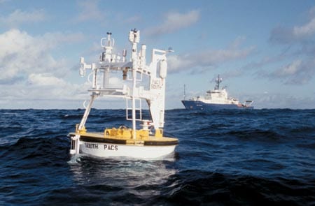
 A WHOI moored surface buoy equipped with meteorological and underwater sensors is deployed in the eastern tropical Pacific Ocean from Scripps Institution of Oceanography's R/V Roger Revelle. (Roger Archibald.)
- Fixed in strategic ocean locations, surface and subsurface moored observatories can track oceanic processes and airsea interactions that influence Earth's climate.
- A proposed network of fixed moored ocean observatories would be chosen among potential sites (red dots), whose strategic value for monitoring and understanding the ocean's role in climate has already been identified. The new sites would complement the existing Tropical Atmosphere Ocean (TAO) array of buoys in the tropical Pacific Ocean (shaded region) and the Pilot Research Moored Array in the Tropical Atlantic (PIRATA) (shaded region), whose deployment began in 1997. (Illustration by Jim Canavan)
- Moored profilers move vertically along mooring cables and measure water properties and currents throughout the water column.
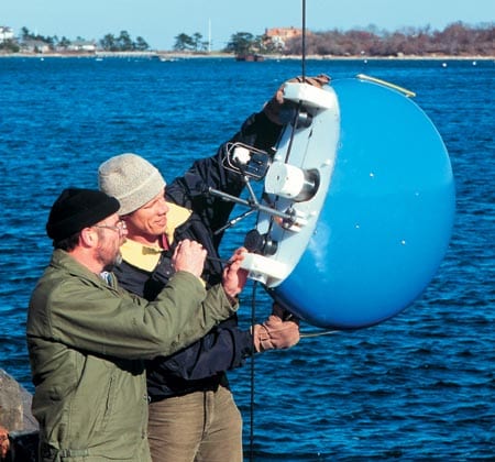
- Research Engineer Steve Liberatore, left, and Research Associate Terry Hammar test a moored profiler in Woods Hole. . (Tom Kleindinst)

