What are rivers, estuaries, and deltas?
The vast majority of freshwater that originates on land via rain, snowfall, and groundwater eventually reaches the ocean. This water travels downhill via streams and rivers, transporting dissolved ions and nutrients, sediment, and pollution as it goes. These waterways are strongly affected by human activities, such as fertilizer use, damming, deforestation, and construction.
Rivers are bands of freshwater carried downhill by the force of gravity. They are fed by smaller tributaries and can, themselves, merge with other tributaries to form even larger rivers.
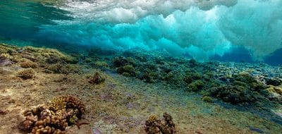
Estuaries are stretches where rivers approach the ocean. They are influenced by freshwater from upstream as well as the influx of saltwater from rising tides.
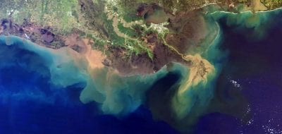
Deltas are areas near the mouth of a river or estuary, where these moving bodies of water deposit large amounts of sediment.
Rivers
Rain, meltwater, and sometimes groundwater run downhill, pulled by gravity into valleys. Here the water accumulates and forms small creeks. Where valleys merge, so too do the creeks, forming streams, which later merge to form rivers. These smaller streams and creeks are called tributaries, and they form a network of branches that collect water from a large area of land. All land that drains into one river system is called a watershed or drainage basin, and all activities that take place on that land have the potential to impact rivers downstream. This includes use of fertilizers and pesticides on lawns or farm fields, mining operations, loss of topsoil, and more.
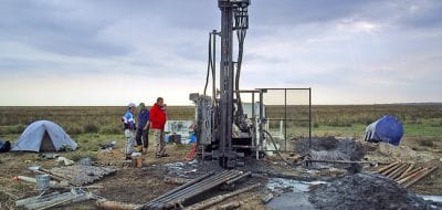
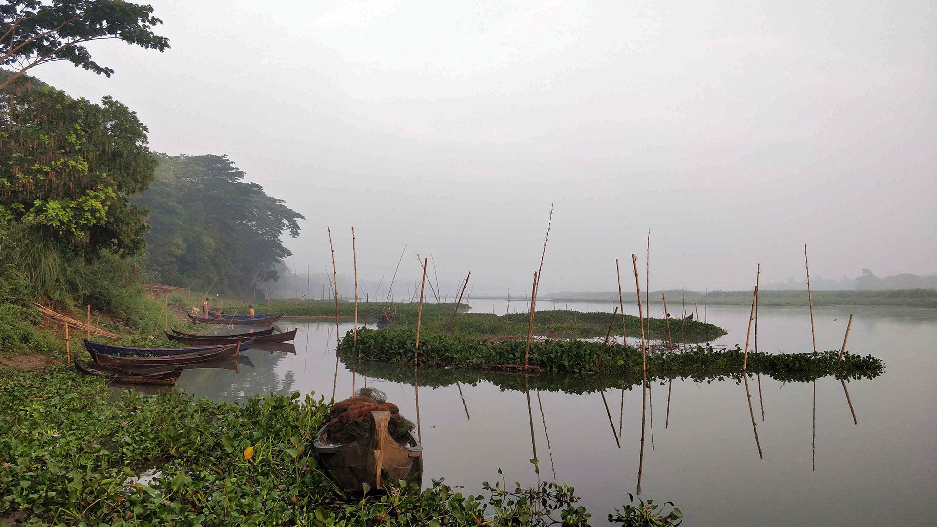
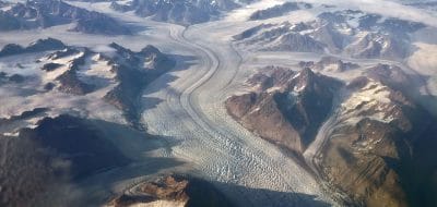
Canada's Fraser River transports more than water it also transports clues that can help scientists understand the global carbon cycle. As the river winds from the Rocky Mountains and Coast Range toward the ocean, it picks up carbon from the atmosphere, rocks and plants. Some of this carbon is deposited into the ocean, where it can lie buried on the seafloor for millions of years. Scientists participating in the Global Rivers Observatory analyze rivers like the Fraser to track the age of sediments, where they came from, where carbon enters and exits the river, and ultimately how this complex process influences Earths climate. (Photo courtesy of Bernhard Peucker-Ehrenbrink, Woods Hole Oceanographic Institution)
As water flows toward the ocean, it erodes the earth, picking up sediment as it travels. Small pieces of sediment stay suspended in the water column, but strong flows also move larger pieces of gravel and rock. These roll along the riverbed as they go, which wears down the outer surface of individual grains of rock, contributing to the smooth appearance of river rock.
When left to flow naturally, rivers meander, shifting their banks over time. Sediment from upstream may be deposited as sand bars form in the middle of the river, providing temporary habitat for birds and other animals. Annual floods contribute to changes in the river’s course, as large volumes of fast-flowing water can displace sand bars and carve new channels into the floodplain. Sediment picked up during floods can be transported all the way to the ocean.
Rivers are the lifeblood of almost all terrestrial life. The power they contain can be harnessed with hydroelectric dams, but construction of dams vastly alters the ecosystems both up- and downstream by removing streamside habitat, changing water temperatures, and trapping sediment. These changes have had profound effects on fish populations and those of other aquatic organisms, and can also impact the chemistry, biology, and ecosystems of coastal areas where the rivers discharge.
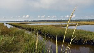
Estuaries
As rivers near the ocean, they reach a point at which saltwater from incoming tides begins to mix with freshwater flowing downstream. This creates the brackish conditions of an estuary. The two types of water are not always evenly mixed, however. The salinity of any location in an estuary varies with the rate of freshwater flow, strength of incoming tides, wind speed and direction, and estuary shape, all of which can and do change over time.
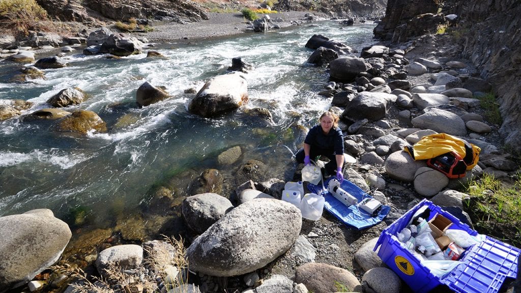
MIT-WHOI Joint Program Student Christine Mingione was collecting water samples from Waquoit Bay and Little River at the Waquoit Bay National Estuarine Research Reserve. (Photo by Tom Kleindinst, © Woods Hole Oceanographic Institution)
In geologic terms, estuaries are defined by their shapes and origins. Broad, relatively shallow estuaries are the result of drowned river valleys—rivers that were inundated by rising seawater when ice sheets melted after the last Ice Age. In some areas, glaciers carved out deep, V-shaped fjords along coastlines. These estuaries are separated from the ocean by a shallow sill that prevents extensive movement of saltwater up into the estuary. Abrupt movement of tectonic plates can cause land to sink, creating tectonic estuaries. And some estuaries are the result of sand accumulation, which creates barrier beaches and barrier islands. These bar-built estuaries often have a protected lagoon with little freshwater flow during most of the year.
When freshwater meets saltwater, mixing occurs, and the extent of mixing is also used to define estuaries. In a salt-wedge estuary, freshwater traveling downstream flows over the top of encroaching saltwater, which is denser than freshwater. In areas with fast-flowing rivers and weak tides, the two masses of water remain largely separate, although some mixing occurs along the barrier. Very large rivers, such as the Mississippi and Amazon, have such a strong flow that mixing of fresh- and saltwater only occurs beyond the river mouth.
Fjords similarly have little mixing of fresh and saltwater, in this case because of the shallow sill, which creates a barrier to incoming seawater. Fresh water flows over the sill and out into the ocean, but the water trapped behind the sill tends to become stagnant and deprived of oxygen.
Other estuaries have water that is better mixed, with slightly stratified estuaries experiencing some mixing of fresh- and saltwater at all depths. These estuaries tend to be saltier near the bottom, with salinity decreasing near the surface. Vertically mixed estuaries are well mixed with consistent salinity from top to bottom.
Estuaries are biologically diverse locations home to a myriad of organisms adapted to survive in the brackish, ever-changing waters. As water moves through estuaries, the chemical composition of nutrients and other ions change, which can have broad impacts once that water reaches the ocean. They also trap much of the sediment transported downstream by rivers, and a muddy layer typically forms over the bottom of the estuary.
Deltas
As sediment builds up along the bottom of an estuary, it begins to form a delta. Continued accumulation of sediment can build land well beyond the mouth of the river. Deltas most often form when the sediment-rich river empties into a protected area, behind a reef, barrier island, seasonal sea ice, or into a small body of water, such as a gulf or sound. At the mouth, the river divides into smaller channels, each of which distributes sediment to a different lobe of the delta. Lobes do not stay in one location for long periods of time. Instead they shift as submarine depressions fill with sediment. Over thousands of years, the Mississippi Delta has shifted hundreds of kilometers (miles) along the Louisiana coast.
The Ayeyawady River delta in Myanmar is home to millions of people and is a hub of agricultural activity for the country. Unlike other large rivers across the world, it has been relatively untouched by large infrastructure and dam projects for the past 50 years. A new study led by WHOI geologist Liviu Giosan showed that shifts in monsoon climate have changed the shape of delta in the past, and suggests that human impact could drastically alter the region in the future. (Photo by Liviu Giosan, © Woods Hole Oceanographic Institution)
The shape of a delta is strongly affected by tidal currents and wave action, which move new sediment along the shoreline. Areas with little wave or tidal action often resemble a bird foot, with rounded lobes growing around each channel. Where there are strong tidal currents, the channels erode, creating islands between them. Areas with strong waves tend toward a scalloped shape, as waves eat away at the leading edge of the delta.
Like rivers and estuaries, deltas are biologically diverse and have a large impact on marine life, people, and the biogeochemical cycles of many elements.
 Image
Image
Herring Catchers
Collecting river herring specimens in a local creek are (from left) WHOI Summer Student Fellow Sara Hamilton, MIT-WHOI Joint Program student Ellie Bors, and WHOI lab assistant Julie Pringle. The fish swim from the ocean up coastal streams to spawn in fresh water each spring. In recent years, however, their populations have plummeted. WHOI biologist Joel...
 Image
Image
The Once and Future Marsh
WHOI biogeochemist Amanda Spivak (center) collects plant and sediment samples in Barstable Great Marsh with the help of research assistant Kelsey Gosselin (left) and MIT-WHOI Joint Program student Sheron Luk (right). Together with collaborators from the Cape Cod Mosquito Control Project, the U.S. Fish and Wildlife Service, the U.S. Geological Survey, Waquoit Bay National Estuarine...
 Image
Image
Hot Spots on the River
WHOI scientists used a drone equipped with a thermal imaging sensor to create this image (inset) of a section of the Coonamessett River watershed in Falmouth, Mass. The thermal image reveals “hot spots”—red and yellow areas—where warmer groundwater is seeping into the colder river in winter. The research will help planners at the Coonamessett River...
 Image
Image
Conserving our Coasts
WHOI marine chemist Amanda Spivak studies salt marshes such as this one near Waquoit Bay in Mashpee, Mass. She is starting a project to understand how New England’s nearly century-old practice of digging ditches to increase drainage and reduce habitat for mosquitoes has affected marsh topography and carbon storage. Hers is one of six new...
 Image
Image
Sampling a Salt Marsh
Coastal wetlands play a critical but poorly understood role in global climate, transferring carbon between the atmosphere, sediments, and coastal ocean. The amount of carbon—and carbon dioxide—moving in and out of salt marshes changes throughout the year, and, to better understand that movement, WHOI and the U.S. Geological Survey (USGS) are measuring how these levels...
 Image
Image
Global River Samples
Summer Student Fellow Julia Paine of the University of Miami (middle) and guest student Soumita Boral from the Indian Institute of Technology at Kanpur (left) analyze water samples from the Ganges, Brahmaputra, and Fraser Rivers with guidance from their advisor, Bernhard Peucker-Ehrenbrink, a geochemist at WHOI. The work is part of the Global Rivers Observatory, a collaborative...
 Image
Image
Clues in the Core
Sarah Jayne, a guest student from Northeastern University working in the lab of WHOI biochemist Amanda Spivak, breaks down a piece of core sampled from the Kennebec river watershed in Maine. Removal of dams from some parts of the river recently resulted in the restoration of river herring populations. Herring have an important role in...
 Image
Image
River Detectives
Canada’s Fraser River transports more than water—it also transports clues that can help scientists understand the global carbon cycle. As the river winds from the Rocky Mountains and Coast Range toward the ocean, it picks up carbon from the atmosphere, rocks and plants. Some of this carbon is deposited into the ocean, where it can...
 Image
Image
Getting Colder
William Melvin from Cornell University wades into the mouth of the Trunk River in Falmouth to set the anchor for a set of temperature sensors to measure the temperature gradient along the river’s outflow. Melvin was taking part in the Partnership Education Program, which was started in 2009 by WHOI and five other Woods Hole...
 Image
Image
Shining Rivers
From the air, the Fraser River Delta and the Straight of Georgia near Vancouver, Canada, reflect the evening sun, with the Coast Range mountains in the background right. WHOI chemist Bernhard Peucker-Ehrenbrink and WHOI graduate student Britta Voss flew over the highly developed delta with a pilot from Lighthawk, a volunteer organization that donates flight...
 Image
Image
Where River Meets Ocean
WHOI geochemist Bernhard Peucker-Ehrenbrink samples a small stream in the “Ancient Forest” of the upper Fraser River basin as part of the Global Rivers Project. The region in British Columbia includes a patch of old-growth inland rain forest with trees at least 1,000 years old. Since many are hollow inside, tree rings cannot be used...
 Image
Image
Deep in the Delta
After their helicopter landed on a remote lake in the Mackenzie River Delta, marine geochemist Daniel Montluçon (in blue), geologist Liviu Giosan (in grey), and Allen Firth (Gwich’in observer, in black) drilled a hole through the ice and deployed a piston core to retrieve sediment. The team retrieved sediment cores from 22 deltaic lakes during...
 Image
Image
From a river to the ocean
Research Associate Paul Henderson collects a water sample from the Talofofo River, Guam. Samples like this help researchers better understand the effects, both locally and globally, of coastal contaminants in groundwater. As groundwater travels to the ocean, it passes through “subterranean estuaries,” a mixing zone between fresh and salty water analogous to the region where...
 Image
Image
Student Science
Summer Student Fellow DeAnna McCadney prepares equipment to gather samples for groundwater studies at the Waquoit Bay National Estuarine Research Reserve in East Falmouth, Mass. Researchers study how underwater aquifer systems exchange water, nutrients, and pollutants between the ocean and freshwater systems. (Photo by Tom Kleindinst, Woods Hole Oceanographic Institution)
 Image
Image
Coring for Clues
WHOI geologist Liviu Giosan and colleagues cruise through a man-made canal in the Danube Delta in search of sites to take sediment cores. The history of the 6,000-year-old river delta is buried beneath the wetland.(Courtesy of Liviu Giosan, Woods Hole Oceanographic Institution)
References
Taking the Pulse of the Fraser
May 23 to June 10, 2011
Global River Observatory
Advancing the understanding of how climate change, deforestation, and other disturbances are impacting river chemistry and land-ocean connections.
Bianchi, T.S. & M.A. Allison. Large-river delta-front estuaries as natural “recorder” of global environmental change. PNAS, vol. 106. May 19, 2009. doi:10.1073/pnas.0812878106.
NOAA National Ocean Service. Classifying estuaries: By geology. https://oceanservice.noaa.gov/education/tutorial_estuaries/est04_geology.html
NOAA National Ocean Service. Classifying estuaries: By water circulation. https://oceanservice.noaa.gov/education/tutorial_estuaries/est05_circulation.html
University of Washington. Estuaries and Deltas. http://rocky.ess.washington.edu/grg/oldcourses/courses07_08/ess230/lectures/Estuaries-and-Deltas-lecture.pdf
Wampler, P.J. Rivers and streams –water and sediment in motion. Nature Education Knowledge. 2012. https://www.nature.com/scitable/knowledge/library/rivers-and-streams-water-and-26405398/
More topics like this
Changing shorelines & erosion
Waves, currents, wind, storms, and tides form complex interactions over time to cause erosion along some stretches of shoreline and growth in others.
Groundwater
Groundwater is water that exists underground in the spaces between grains of sand or gravel or in the cracks and fractures in solid rock—part of the global water cycle.
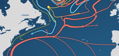
AMOC—The Atlantic Ocean’s conveyor belt
The ocean's conveyor-like global circulation influences today's climate system.
Biogeochemistry
Biogeochemistry studies the cycles of crucial elements, such as carbon and nitrogen, and their interactions with other substances and organisms as they move through Earth's atmosphere, hydrosphere, biosphere, and lithosphere.
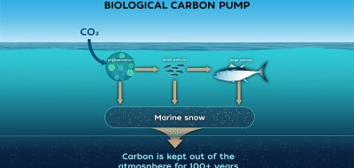
Biological carbon pump
Every day, microscopic phytoplankton pull carbon dioxide from surface waters and send it sinking into the deep sea—where the ocean's biological carbon pump can lock it away for hundreds to thousands of years, quietly shaping Earth's climate.
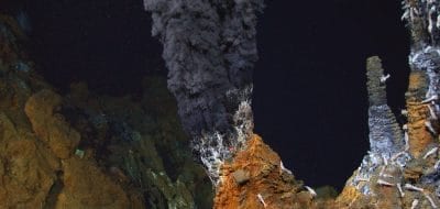
Hydrothermal vents
In the sunless deep, hydrothermal vents gush superheated, mineral-rich fluid from the seafloor, building towering mineral chimneys. Around them thrives one of Earth's strangest ecosystems—tubeworms, shrimp, and microbes that live on chemistry instead of sunlight, powered by the planet's inner heat.
Sunlit zone
The upper layer of the ocean is known as the sunlit, or euphotic, zone. Because water strongly absorbs light, sunlight penetrates only to depths of about 200 meters (656 feet).
Arctic ocean circulation
The complex ocean circulation system in the Arctic — which impacts the entire food web — is in a delicate balance.
Carbon cycle
Carbon is the building block of life on Earth and has a powerful impact on the planet’s climate.
Cycles
Oceanic cycles — chemical, physical, and biological — are related to cyclic processes in the Earth's atmosphere, such as the seasons, El Niño events, and long-term climate changes.
Glaciers & ice sheets
Glaciers are large ice masses created by snowfall that has transformed into ice and compressed over the course of many years. An ice sheet is a mass of glacial land ice extending more than 20,000 square miles.
Mid-ocean ridges
The mid-ocean ridge occurs along boundaries where plates are spreading apart.
Twilight zone
The ocean twilight zone is a layer of water that stretches around the globe. It lies 200 to 1,000 meters below the ocean surface, just beyond the reach of sunlight.
Currents, gyres, & eddies
At the surface and beneath, currents, gyres and eddies physically shape the coasts and ocean bottom.
Frozen ocean
The polar regions are experiencing unprecedented environmental changes that have significant potential impacts on global climate, ecosystems, and society.
Midnight zone
The midnight zone, or bathypelagic, extends to about 4,000 meters (about 13,100 feet), which reaches the ocean floor in many places is in perpetual darkness.
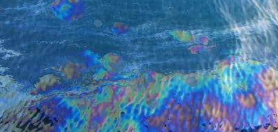
Natural oil seeps
As much as one half of the oil that enters the coastal environment comes from natural seeps of oil and natural gas.
Ocean acidification
Ocean acidification is a reduction in the pH of the ocean over an extended period of time, caused primarily by an increase of carbon dioxide from the atmosphere.
Oxygen dead zones
Dead zones occur when the water lacks oxygen. Like us, marine animals require oxygen to breathe, and when oxygen levels drop too low they can suffocate.
El Niño
El Niño is a warming of surface waters in the eastern tropical Pacific Ocean, while La Niña is a cooling event.
Oceanus Magazine
[ ALL ]In-depth research on Rivers, estuaries, & deltas
How an MIT-WHOI student used Google Earth to uncover a river–coral reef connection

Where the Rivers Meet the Sea

On (and Below) the Waterfront

Up in the Sky!

Earth’s Riverine Bloodstream

River Quest

Climate Change Spurred Fall of Ancient Culture