Please note: You are viewing
the unstyled version of this website. Either your browser does not support CSS
(cascading style sheets) or it has been disabled. Skip
navigation.
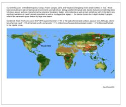
With support from the "Emerging Topics in Biogeochemical Cycles" (ETBC) Program of the National Science Foundation (OCE-0851015) we are characterizing the sources, pathways and timescales of riverine export of organic and inorganic carbon from land to the ocean. This is accomplished by integrating detailed geochemical information on temporal and spatial changes in the composition of the dissolved and particulate river loads with spatially and temporally resolved data on relevant ecosystem, hydrologic, geologic, geomorphologic and climatologic characteristics derived from remote sensing and GIS mapping. The study is conducted on six large river basins (see Figure) by scientists from the Woods Hole Oceanographic Institution (WHOI), the Woods Hole Research Center (WHRC), and the University of New Hampshire (UNH), in collaboration with colleagues in China, Russia, Canada, Bangledesh, India, the Republic and Democratic Republic of the Congo, France and Switzerland. Such a holistic approach to river basin studies is urgently needed to assess the surficial carbon subcycle that connects – via rivers - terrestrial primary productivity with long-term carbon sinks in the ocean. This study will generate a unique dataset and serve as a benchmark for future studies aimed at tracking the impact of environmental change on carbon transport from land to the oceans. Results from this study will also provide a framework for interpreting longer-term records of environmental change that are preserved in marine sediments deposited seaward of river mouths. Brahmaputra - Changjiang - Congo - Fraser - Ganga - Lena Our work focusses on the Brahmaputra, Congo, Fraser, Ganges, Lena (and Kolyma) and Yangtze (Changjiang) rivers (basin outlines in red). These basins include arctic as well as tropical environments; permafrost and deeply weathered tropical soils; basins that are dominated by steep hill slopes as well as those characterized by extensive floodplains; basins with moderate as well as high rainfall and with moderate to very significant variations in runoff; densely populated as well as mostly pristine regions - the basins chosen for in-depth studies thus span most of the parameter space defined by large river basins. Combined, these basins cover 9,674,874 square kilometers (~9% of the total exhoreic land surface), account for 3,909 cubic kilometers of annual runoff (~9% of the total runoff), and deliver ~1713 million tons of suspended particulate matter (~12% of the world's total) to the coastal ocean. Outreach Activities This research initiative constitutes the first large-scale joint research project of scientists from the WHRC, WHOI, and UNH with international collaborators aimed at investigating land-ocean transport by river systems. The project provides a collaborative research, training and learning environment for undergraduate (REU) and graduate (MIT/WHOI Joint Program) students as well as postdoctoral scientists at WHOI and the WHRC. The project also increases the participation of underrepresented groups, a cross-institutional priority in Woods Hole, through international collaborations and exchanges between the participating group members and volunteers. Involvement of local collaborators in sampling is essential to generating temporally resolved data. Our project enhances the research and educational infrastructure needed for a long-term “World River Observation Network” of land-ocean transport processes under changing environmental conditions. As a research initiative of this scale requires integrating legacy data with new data generated by this study, we are contributing to an ongoing Cyberinfrastructure initiative focused on river systems (e.g. GEMStat/UNEP GEMS/Water database). Finally, based on a successful pilot program on the Lena River, we are developing a traveling art exhibition based on the artwork of students living near our study sites in Siberia, Bangladesh, India, Canada, China, and Africa. The “My River, My Home” exhibition engages the local population at the study sites and convey the scientific and cultural aspects of the project to a wider public. Thus far, students living on the Lena, Fraser and Congo rivers have been participating in this outreach activity. Last updated: January 13, 2011 | ||||||||||||||||
Copyright ©2007 Woods Hole Oceanographic Institution, All Rights Reserved, Privacy Policy. | ||||||||||||||||