
Geology & Geophysics
The Spiral Secret to Mammal Hearing
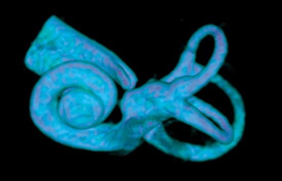
The spiral secrets of mammals? hearing abilities Whispering galleries are curious features of circular buildings. As whispers travel along the buildings’ curved walls, they remain loud enough to be heard…
Read MoreDeeply Submerged Volcanoes Blow Their Tops
A research team led by Woods Hole Oceanographic Institution (WHOI) has uncovered evidence of explosive volcanic eruptions on the Arctic Ocean seafloor almost 2.5 miles deep. Scientists did not think…
Read MoreCrack! A Lake Atop Greenland Disappears
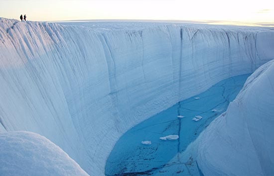
In late July 2006, a 2.2-square-mile lake atop the Greenland Ice Sheet sprung a leak. Like a draining bathtub, the entire lake emptied from the bottom, sending water through a…
Read MoreAntarctic Andrea

The sound of boots crunching on brick-red gravel filled the thin Antarctic air. Three scientists—geologists from Woods Hole Oceanographic Institution (WHOI)—had been climbing for 30 minutes, staring at their feet…
Read MoreEarth, Wind, and Fire in Antarctica

From a windy, isolated camp in southern Victoria Land, Antarctica, three scientists from Woods Hole Oceanographic Institution explore how the waterless, lifeless, volcanic terrain formed and evolved. Read the story…
Read MoreArctic Voyage Tests New Robots for Ice-covered Oceans
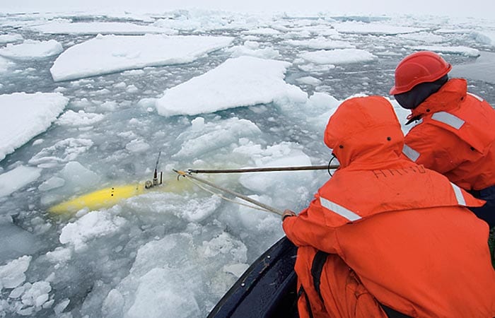
In the summer of 2007, an international team led by scientists at Woods Hole Oceanographic Institution sailed to the Arctic Ocean aboard the Swedish icebreaker Oden. Their missions: to test…
Read MoreNew System to Take Long Seafloor Cores Is Ready to Go
Over five years, engineers had designed, built, and tested components for a new, one-of-a-kind system to extend the length of sediment samples cored from the sea floor. In September, they…
Read MoreEarth’s Moving Crust May Occasionally Stop
The motion, formation, and recycling of Earth?s crust?commonly known as the theory of plate tectonics?have long been thought to be continuous processes. But new research by geophysicists suggests that plate tectonic motions have occasionally stopped in Earth?s geologic history, and may do so again.
Read MorePlumbing the Plume That Created Samoa
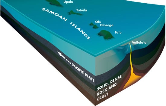
Matthew Jackson began his journey to the center of the Earth on lonely gravel roads in Montana. Uninterested in motorcycles and horses, and miles from neighbors and friends, Jackson roamed…
Read MoreNew Wrinkles in the Fabric of the Seafloor
Deborah Smith first heard the strange rumbling from the seafloor in 2001 and was eager to get to the bottom of it. The ocean commotion was detected by underwater hydrophones…
Read MoreSummer Under Arctic Ice
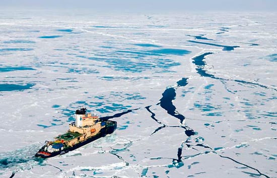
This month, an international team of scientists and engineers are exploring the seafloor of the Arctic Ocean while cruising aboard the Swedish icebreaker Oden. The science team is sending three…
Read MoreFragmented Structure of Seafloor Faults May Dampen Effects of Earthquakes
Many earthquakes in the deep ocean are much lower in magnitude than expected. Geophysicists from the Woods Hole Oceanographic Institution (WHOI) have found new evidence that the fragmented structure of seafloor faults and previously unrecognized volcanism may be dampening the effects of these quakes.
Read MoreExplorers to Use New Robotic Vehicles to Hunt for Life and Hydrothermal Vents on Arctic Seafloor
Researchers will probe the Gakkel Ridge during expedition that begins on July 1.
Read MoreWHOI Geologists Compile Longest Ever Record of Atlantic Hurricane Strikes
The frequency of intense hurricanes in the Atlantic Ocean appears to be closely connected to long-term trends in the El Ni?o/Southern Oscillation and the African monsoon, according to new research from the Woods Hole Oceanographic Institution (WHOI). Geologists Jeff Donnelly and Jonathan Woodruff made that discovery while assembling the longest-ever record of hurricane strikes in the Atlantic basin.
Read MoreDeep Ocean Waters Don’t Run Still
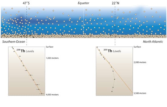
The ocean’s circulation is thought to play an important role in our climate by transporting heat from tropical regions toward Earth’s poles. Of particular interest is the circulation in the…
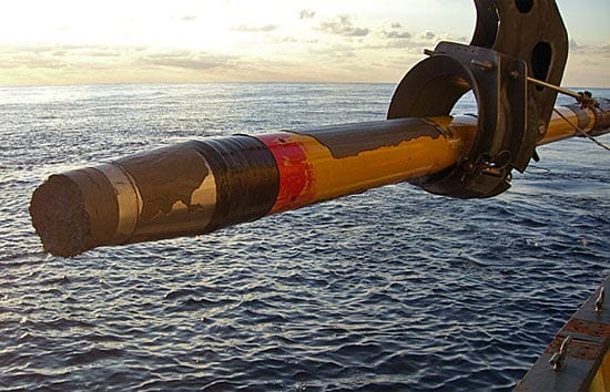
Read MoreThe Lo-o-o-ng Core
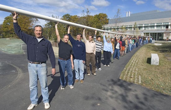
Since the early part of the 20th century, scientists have been going to sea on ships equipped with long, hollow pipes called corers. These corers are used to collect seafloor…
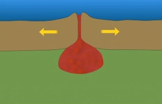
Read MoreA Ridge Too Slow?

Ever since scientists first discovered vents gushing hot, mineral-rich fluids from the seafloor in the Pacific Ocean 30 years ago, they have found them in various places along the Mid-Ocean…
Read MoreCell-sized Thermometers

Climate shifts are a repeating feature in Earth’s history, but humans have added so much greenhouse gas (especially carbon dioxide) to the atmosphere that climate is warming in our lifetimes.…
Read MoreScientists “See” New Ocean Floor Just Before and After It Is Created
A multidisciplinary research team from six institutions has for the first time successfully anticipated and then chronicled a seafloor eruption along the global mid-ocean ridge, the most active volcanic system on Earth. The event along the East Pacific Rise has provided researchers from Woods Hole Oceanographic Institution (WHOI) with a rare opportunity to observe what happens in the immediate aftermath of an eruption.
Read MoreA Rare Glimpse Into the Ocean’s Crust

About one and a half million years ago, a great hidden piece of the ocean’s crust uplifted and rotated, giving Clare Williams a window and a time machine into Earth’s…
Read MoreLessons from the 2004 Indian Ocean Tsunami
Woods Hole Oceanographic Institution will convene two special conferences this fall to learn from the devastating 2004 tsunami that left more than 220,000 people dead or missing. In July, another…
Read MoreUndersea Vehicles to Study Formation of Gold and Other Precious Metals On the Pacific Ocean Floor
An international team of scientists will explore the seafloor near Papua New Guinea in the western Pacific Ocean later this month with remotely operated and autonomous underwater vehicles, investigating active…
Read MoreNew Hybrid Deep-sea Vehicle Is Christened Nereus
Nereus—a mythical god with a fish tail and a man’s torso—was chosen Sunday (June 25) in a nationwide contest as the name of a first-of-its-kind, deep-sea vehicle under construction at…
Read MoreInto the ‘Mouth of Hell’
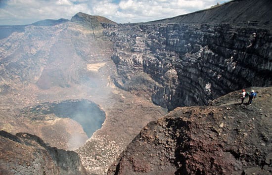
Ken Sims peers over the rim of Masaya Volcano and looks 2,000 feet (600 meters) down into the smoking crater lined with rows of jagged rocks that jut up like…
Read More