
Advisory: WHOI Works with Mass Clean Energy Center on Offshore Wind Measurements
October 6, 2016
This week, scientists from Woods Hole Oceanographic Institution, as part of a project funded by the Massachusetts Clean Energy Center (MassCEC), will install a “Wind Cube” laser-based instrument off the coast of Martha’s Vineyard to remotely sense wind speeds up to 200m (650 ft) above sea level. The instrument will be deployed in the vicinity of the Massachusetts wind energy area south of Martha’s Vineyard – the likely location for up to 1,600 megawatts of offshore wind turbines as called-for by the Energy Diversity Act recently signed by Massachusetts Governor Charlie Baker.
Deployment of the wind measurement equipment is part of MassCEC’s multi-year effort to gather baseline technical and environmental data in the wind energy areas. The data collected will inform and guide offshore wind developers, utilities and public agencies during the planning, procurement, construction and operation of offshore wind.
WHOI researchers with representatives of MassCEC will host a press availability to discuss the project and to provide an opportunity to reporters to view the “Wind Cube” laser instrument prior to its at-sea deployment, scheduled for Friday.
When/where:
Thursday, October 6, at 10 a.m.
Woods Hole Oceanographic Institution Iselin Dock
86 Water St.
Woods Hole, MA 02543
Who:
Participants include:
- Anthony Kirincich, Physical Oceanographer, Woods Hole Oceanographic Institution
- Bill White, Senior Director of Offshore Wind, MassCEC
Background:
About the Wind Cube: This laser-based (LIDAR) system sends non-visible laser beams in five different directions above the instrument. The light bounces off small particles and returns to the instrument, from which the direction and speed of the winds aloft can be estimated. This baseline data will provide wind energy developers with a validated reference point to base future offshore wind energy projects on.
About the instrument deployment location: The LIDAR instrument will be deployed at the Air-Sea Interaction Tower (ASIT) at the Martha’s Vineyard Coastal Observatory. The MVCO was built and is operated by WHOI, and has been providing data in real time to the scientific community and general public for 15 years. The ASIT is located two miles south of Edgartown Great Pond in 50 feet of water. The Tower extends roughly 76 feet above the surface of the ocean.
About WHOI: The Woods Hole Oceanographic Institution is a private, non-profit organization on Cape Cod, Mass., dedicated to marine research, engineering, and higher education. Established in 1930 on a recommendation from the National Academy of Sciences, its primary mission is to understand the ocean and its interaction with the Earth as a whole, and to communicate a basic understanding of the ocean’s role in the changing global environment. For more information, please visit www.whoi.edu.
About MassCEC: The Massachusetts Clean Energy Center (MassCEC) is dedicated to accelerating the success of clean energy technologies, companies, and projects in the Commonwealth—while creating high-quality jobs and long-term economic growth for the people of Massachusetts. Since its inception in 2009, MassCEC has helped clean energy companies grow, supported municipal clean energy projects, and invested in residential and commercial renewable energy installations creating a robust marketplace for innovative clean technology companies and service providers. MassCEC is also committed to making clean energy infrastructure investments such as the Wind Technology Testing Center in Boston and the New Bedford Marine Commerce Terminal.
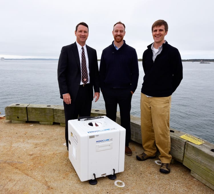
WHOI physical oceanographer Anthony Kirincich, right, Bill White, left, senior director of Offshore Wind, Massachusetts Clean Energy Center (MassCEC), and Tyler Studds, senior manager of Renewable Energy Strategy, MassCEC, center, stand with the “Wind Cube,” a laser-based instrument that remotely senses wind speeds. The instrument will be deployed off the coast of Martha’s Vineyard as part of the MassCEC multi-year effort to gather baseline data to inform and guide offshore wind developers, utilities and public agencies during the planning, procurement, construction and operation of offshore wind.
(Photo by Ken Kostel, Woods Hole Oceanographic Institution)