About Moorings & Buoys
An excerpt from “Outposts in the Ocean” by Robert Weller, Oceanus magazine, 2000
The vast interface of ocean and atmosphere constitutes one of the earth’s great interactive engines. WHOI scientists have long investigated upper-ocean and atmospheric processes and their influences on one another...
In the past, a network of ocean weather stations provided a treasure trove of data for oceanographers and played an essential role in early efforts to build initial understanding of how the ocean changed over time and how it responded to, and in turn influenced, atmospheric changes. Primarily to guide transoceanic-voyaging aircraft after World War II, the U.S. and four other countries established 13 sites in the North Atlantic and the Pacific Oceans (labeled alphabetically, starting with “A”) that were constantly occupied by ships. Planes would check in with ships to receive a position and weather data. Ship crews used weather balloons to gather air temperature, humidity, pressure, and wind direction and speed, and, while on site, they also collected a wealth of oceanographic measurements...
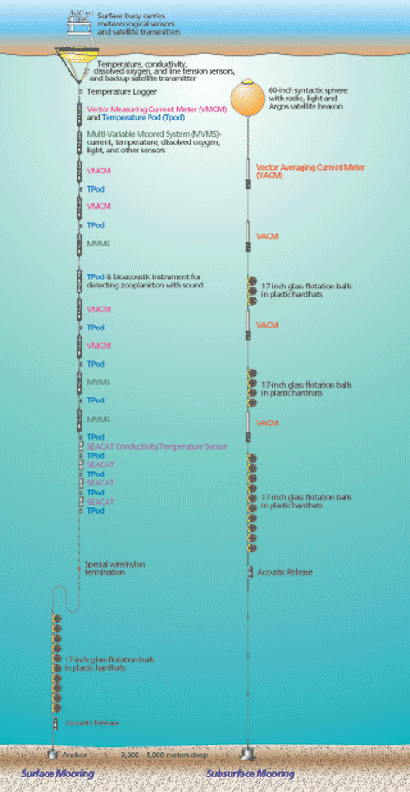
Development of moored surface buoys was an extremely difficult task because of the effect of surface motion on mooring components. Since the 1960s, scientists have used subsurface moorings to observe ocean currents and water properties. These are instrumented cables, anchored to the seafloor and attached to buoyant floats that reach upward toward, but not to, the sea surface. In contrast, surface moorings have surface floats with downward-hanging cables. Instruments along the submerged cables measure water temperature and salinity, and the speed and direction of currents. The surface floats additionally provide a platform for sensors that measure wind speed and direction, incoming shortwave radiation, incoming long-wave radiation, relative humidity, air temperature, barometric pressure, and precipitation.
Both types of mooring technologies have matured to the point where they can measure atmospheric and/or oceanic changes as frequently as once per minute and can take oceanographic measurements meter-by-meter in the water column. Both are now capable of sustained operation for long time periods. Sensors on surface buoys now perform reliably for periods of six to 12 months. Data are both transmitted via satellite and recorded on board.
Unlike surface moorings, which are exposed to winds, salt spray, surface wave motion, fouling by marine growth, and disturbances by vandals, subsurface moorings are subject to less stressful conditions and now routinely collect information for periods of up to two years without servicing. In the past 30 years, WHOI alone has deployed almost 1,000 subsurface moorings in all parts of the world’s oceans. Information gathered from them has been used to begin to understand how the oceans change over space and timewith an emphasis on time scales of less than a year or so. In some parts of the ocean, such as the northwest North Atlantic, we have made enough measurements to be able to construct a three-dimensional “picture” of the ocean’s mean circulation and to estimate the speed and volume of waters transported by important currents.
Today WHOI researchers are world leaders in air-sea observations, surface mooring technology, upper-ocean dynamics, and the ocean’s role in climate, and they look forward to continuing their pioneering work in air-sea interaction in future decades.

