
By Randy Showstack
Steve Jayne says that flying through hurricanes on a Lockheed-Martin WC-130J Weatherbird aircraft with the U.S. Air Force Reserve’s Hurricane Hunters sounds more exciting than it is. He’s never felt in any danger, though sometimes the turbulence associated with the rising air in a storm’s eyewall “can get a little spicy,” he said.
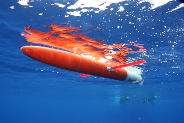
For Jayne, a senior scientist in the Physical Oceanography Department of the Woods Hole Oceanographic Institution, it’s all in a day’s work when he needs to deploy parachute-equipped Air-Launched Autonomous Micro Observer (ALAMO) floats through a chute in the back of the plane to study hurricane conditions.
Hurricanes feed off of heat in the upper ocean, which fuels their formation and intensity. With the Atlantic hurricane season underway, WHOI scientists are innovating with a variety of underwater floats and gliders—including ALAMO floats— to collect data about ocean warmth in the Gulf Stream and some other parts of the ocean to improve hurricane forecasting and preparedness.
Following the economic damage from Superstorm Sandy in 2012, Jayne helped to develop the ALAMO floats. Each year, he or a colleague seed a line of ALAMOs around a hurricane development region. As the floats move up and down the water column, they measure water temperature, salinity, pressure, and the ocean surface wave field, and help forecast modelers and others understand how the ocean and storm interact. He’s working on developing sensors to measure ocean currents and acoustics to infer wind conditions. This year, the National Oceanic and Atmospheric Administration also has deployed ALAMOs as part of its research efforts.
While ALAMOs can be dropped from a plane exactly where needed, autonomous underwater Spray gliders slowly dive and climb through the upper ocean along a defined heading in a saw-tooth pattern.
Robert Todd, an associate scientist in the Physical Oceanography Department who uses the gliders to routinely survey the Gulf Stream, said they move about a half knot horizontally. That’s not nearly fast enough to outrun the Gulf Stream or chase down a storm. However, the gliders are well-suited to gather data while repeatedly crisscrossing oceanic boundary currents, such as the Gulf Stream, that are typically associated with strong gradients of temperature and other properties.
“Some of the most powerful data we can get are measurements across strong gradients. You want to know where there is a big change in temperature, salinity, or currents over a short distance,” said Todd, who oversees deploying a glider every other month to wend its way from Florida to Massachusetts while measuring temperature, salinity, currents, and some biological data. “Those are precisely the types of measurements that the Spray gliders provide us.”
A mainstay in studying the ocean is the Argo global program of about 3,900 floating robots that measure temperature and salinity data in the ocean’s upper two kilometers. WHOI maintains a fleet of 350-400 Argo floats in the Atlantic basin at any given time.
Typically, Argo floats take an ocean profile every 10 days as the floats drift with the ocean currents and go up and down the water column. However, this year WHOI has put 38 floats that are in the Gulf of Mexico and the Tropical Atlantic Ocean onto an accelerated schedule of every 2.5 days While the accelerated schedule reduces the overall lifetime of the floats, it could also to improve hurricane forecasts.
“We are taking assets that we already had, but running them quicker during hurricane season,” said Pelle Robbins, a research specialist in WHOI’s Physical Oceanography Department. “We are trying to get some extra data and see if that helps improve the hurricane formation prediction models.”
All three platforms—ALAMO, Spray, and Argo—send back measurements in near-real time that are then distributed for use in the hurricane forecast systems. The measurements help constrain ocean models, particularly the quantity and distribution of heat to fuel storms.
A Spray underwater glider sits on the surface awaiting recovery. Similar gliders routinely provide upper ocean observations in support of hurricane forecasting. Photo by Robert E. Todd.