
Undersea Cracks along Continental Shelf Could Trigger Tsunamis along U.S. East Coast
April 28, 2000
Potential landslides on the outer continental shelf and slope along the Mid-Atlantic coast could trigger tsunamis that might have devastating effects on populated coastal areas. In a paper published in the May 2000 issue of the journal Geology,Neal Driscoll of the Woods Hole Oceanographic Institution and colleagues Jeffrey Weissel of Columbia University’s Lamont-Doherty Earth Observatory and John Goff of the University of Texas at Austin say newly discovered cracks along the edge of the continental shelf could be an early warning sign that the seafloor is unstable in these areas.
These cracks, together with evidence of past landslides in the same area, indicate the sea floor could slump, or slide downhill like an avalanche, triggering the waves. Wave heights similar to the storm surge from a category 3 or 4 hurricane, up to several meters above normal, could occur along the Virginia-North Carolina coastline and lower Chesapeake Bay, the areas of highest risk.
Driscoll, an Associate Scientist in the Woods Hole Oceanographic Institution’s Geology and Geophysics Department, and colleagues found the cracks using NOAA bathymetric data. The researchers say it is unclear whether these cracks are fossil features or are active and therefore likely to produce a potentially large submarine landslide in the near future.
“Coastal areas face increasing threats from a number of natural hazards as their population grows,” Driscoll said. “The public is aware of the damage to coastal areas caused by severe storms like hurricanes thanks to better storm tracking and media coverage of these events. Tsunamis resulting from offshore earthquakes, landslides, and volcanic activity are just as destructive but are not as common. As a result, public awareness of tsunamis is limited, as is our ability to forecast when and where they will strike. The tsunami that struck northern Papua New Guinea in July 1998 with almost no warning killed some 2,000 people.”
The researchers recently discovered a system of en echelon cracks along a 40-kilometer (25-mile) section of the outer continental shelf off southern Virginia and North Carolina, north of Cape Hatteras. The en echelon cracks, a series of cracks offset like the shingles on a roof, are located in water depths of 100 to 200 meters (about 300 to 600 feet) between the Norfolk Canyon and the Albemarle-Currituck submarine slide, which occurred approximately 16,000 to 18,000 years ago.
“Knowledge about submarine landslides will lead to a better understanding of how large-scale slope failure, canyon cutting, and sedimentation interact to create the continental margins,” Driscoll notes. “What kind of hazard if any does this pose? Any future submarine landslides starting on this crack system might trigger a tsunami that poses a danger to populations along the nearby coast, and we should know what the risks are for that happening.”
The researchers say that, although rare on human time scales, if a large submarine landslide were to occur on a continental margin near a populated coastal area, the results could be catastrophic given the development along coastal areas in recent decades. A 1929 tsunami from a landslide associated with a magnitude 7.2 earthquake on the Grand Banks left 51 dead along the south coast of Newfoundland. Tsunami wave heights recorded from that earthquake and landslide reached an estimated 40 feet in some areas along the coast.
Driscoll and colleagues say there are a number of factors that could trigger a slope failure, such as groundwater discharge and the decomposition of gas hydrates from warmer ocean temperatures during interglacial periods. They also note that the tsunami wave heights depend on many factors, among them local topography. A sudden but small volume landslide could generate a tsunami that is more dangerous than a tsunami from a larger but slower moving landslide.
The researchers say more and better bathymetric surveys are needed to find evidence for past landslides and to identify areas of sea floor susceptible to future slope failure. The Office of Naval Research funded their study, with some additional support from NASA.
“These studies have been facilitated by multidisciplinary programs initiated by Dr. Joe Kravitz at ONR” Driscoll notes. “These are complex problems, and the Navy has had the insight to support a wide range of science and engineering efforts to address them.”
The Scientists plan to survey the Mid-Atlantic site in great detail in May using an ONR-funded sonar system called SubScan developed by Edgetech, Florida Atlantic University, and Woods Hole Oceanographic Institution. The high resolution towed system surveys the surface layers as well as the layers beneath the surface, producing detailed three-dimensional images of the seafloor. Driscoll says the two-week cruise, which leaves Woods Hole May 6, will determine if the cracks are normal faults offsetting the seafloor or relic features that have a surface expression.
#
Additional information about Woods Hole Oceanographic Institution can be found on the World Wide Web at: http://www.whoi.edu (general WHOI information)
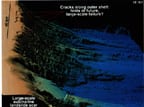
Three-dimensional perspective of continental margin off southern Virginia and North Carolina looking in direction aligned with shelf edge. Shading imitates illumination of seafloor by artificial sun in Northwest. Upper Currituck failure surface is smooth area in foreground, and en echelon crack system is seen farther north on outermost shelf. Inset shows three representative bathymetric profiles over cracks, and their locations are noted on perspective image.
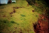
| The land impression of en echelon cracks at Mayagüez, Puerto Rico. |