Geological Tool Helps Scientists Map the Interior of the Ocean
August 7, 2003
A new application of a decades-old technique to study Earth’s interior is allowing scientists “see” the layers in the ocean, providing new insight on the structure of ocean currents, eddies and mixing processes. The findings, reported in this week’s Science by a team from the University of Wyoming and Woods Hole Oceanographic Institution (WHOI), could be a major step forward in the ability to remotely survey the interior of the ocean.
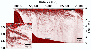
The study reports on a new adaptation of seismic reflection profiling — sending sound into the water and analyzing the return echoes — to create detailed pictures of eddies, internal waves, and other oceanic features that affect climate, fisheries and the spread of pollution.
Seismic profiling has been used for more than 50 years to map Earth’s interior and to explore for oil and gas deposits. This is the first application that may help scientists locate yet-undiscovered mixing sites that may improve understanding of how the ocean absorbs heat and moves it from the equator to the poles. Better understanding of ocean mixing will play a role in improving climate models, said coauthor Raymond Schmitt of the Woods Hole Oceanographic Institution.
Lead author Steven Holbrook of the University of Wyoming, who was a scientist at WHOI from 1988 to 1997, said this new use of an old technique could be a major step forward in studying the ocean. For the first time, scientists are able to image the shapes of water layers with contrasting temperature and salinity and see detailed structures inside the ocean. Seismic reflection profiling, Holbrook said, could prove to be “a revolutionary way of looking at the ocean” and may pave the way for remotely sensing temperature variations inside the ocean and for mapping the boundaries between deep-water and abyssal currents.
The idea for the new application of an established technique developed when Holbrook and colleagues noticed unusual echoes coming from within the ocean while studying the structure of the continent’s edge near the Grand Banks off Newfoundland. He visited WHOI and sought advice from oceanographers on how to interpret the surprisingly strong water column reflections.
Physical oceanographer Ray Schmitt noticed that the size and pattern of Holbrook’s acoustic reflections agreed well with typical characteristics of intrusions — masses of water of similar density but of contrasting temperature and salinity — noted in the same location more than twenty years ago.
However, Schmitt needed physical data on conditions at the time of the seismic surveys to verify his interpretation. Holbrook supplied a temperature profile that confirmed the presence of strong intrusions, and Schmitt was able to infer the salinity, density and sound speed structure from the temperature data. A match was found with the acoustic reflections at that site, confirming that the low-frequency sound energy was reflecting off the gradients in physical properties in the water column. The researchers then used the echoes to create images of the oceanic front between the Labrador Current and the North Atlantic Current.
Their data show structures that are suggestive of intrusions, internal waves, large scale eddies and possibly boundaries of deep water masses. However, aside from the intrusions, there is no confirming physical data to reinforce these other interpretations. Schmitt and Holbrook are now discussing how to perform a combined physical and seismic expedition, possibly with two ships, to confirm their interpretations.
Schmitt said two aspects of seismic reflection profiling make it attractive as a survey tool for oceanic water column structure: the acoustic echoes are obtained throughout the whole water column, and the lateral spacing of the returns is only about 6 meters (about 20 feet), making it easy to track the horizontal extent of reflecting features. Most traditional water column data are collected by repeated lowerings of towed instrument packages, which limits the depth range to a few hundred meters with 500-1000 meter (about 1500 to 3300 feet) spacing between profiles. The new technique allows rapid surveys of ocean structures that change more quickly than traditional methods can observe.
Scientists studying the earth’s interior have been collecting reflections coming from within the ocean for decades but have not paid attention to other uses of the data until now. Holbrook and Schmitt said the water column echoes, although weak, are probably common in seismic reflection profiling data sets that exist all over the world and could be a huge, untapped resource for exploring ocean structure and dynamics.
Until now, the water column signal has been regarded as just noise to the seismologists,” Schmitt said. “New insights into ocean mixing processes open up to us if we think about that ‘noise’ as indeed containing useful signals.”
About WHOI
WHOI is a private, independent marine research and engineering, and higher education organization located in Falmouth, MA. Its primary mission is to understand the oceans and their interaction with the Earth as a whole, and to communicate a basic understanding of the ocean’s role in the changing global environment. Established in 1930 on a recommendation from the National Academy of Sciences, the Institution is organized into five departments, interdisciplinary institutes and a marine policy center, and conducts a joint graduate education program with the Massachusetts Institute of Technology.


