
Image
A Line in the Ocean
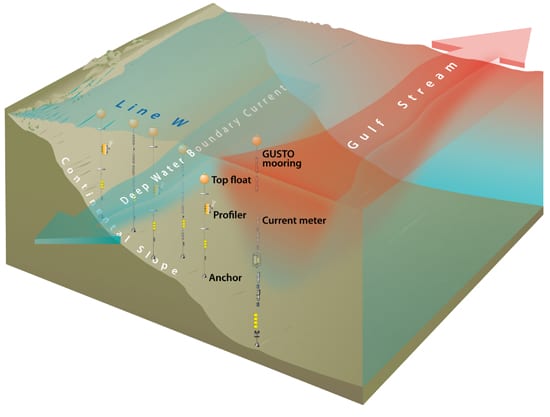
January 2, 2011Line W is an array of five moorings that has been monitoring changes in two currents that play important roles in regulating Earth’s climate: the Gulf Stream (orange area) and the Deep Western Boundary Current hugging the U.S. Eastern Seaboard. It is one component in a long-term, international effort to observe most of the critical regions of the North Atlantic circulation system. Sensors on the Line W moorings take measurements of water salinity, temperature and velocity along both currents. So far, the research team has observed changes that appear to relate to fluctuations in the amount of dense, cold waters that are sinking upstream in the Labrador Sea. The team also reports that since 2000, salinity has decreased in the densest waters of the Deep Western Boundary Current at Line W—a signal, they believe, of fresher upstream waters spilling over the Greenland-Scotland Ridge into the North Atlantic from the Greenland, Iceland and Norwegian Seas (see “Interrogating the Ocean Conveyor” and “Fresher Ocean, Cooler Climate“). Line W was named after former WHOI Physical Oceanography Chair and Scientist Emeritus Valentine Worthington.(Illustration by E. Paul Oberlander, Woods Hole Oceanographic Institution)
Image and Visual Licensing
WHOI copyright digital assets (stills and video) contained on this website can be licensed for non-commercial use upon request and approval. Please contact WHOI Digital Assets at images@whoi.edu or (508) 289-2647.