Is the regime shift in Gulf Stream warm core rings detected by satellite altimetry? An inter-comparison of eddy identification and tracking products
Perez, E., Andres, M., Gawarkiewicz, G. (2024). Is the Regime Shift in Gulf Stream Warm Core Rings Detected by Satellite Altimetry? An Inter-Comparison of Eddy Identification and Tracking Products; Journal of Geophysical Research: Oceans, 129(10), e2023JC020761. https://doi.org/10.1029/2023JC020761

Figure provided by Elena Perez.
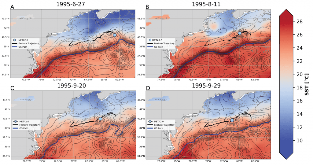
The evolution of a warm core ring (WCR)-like eddy from the META2.0 data product (matched to a July 1995 WCR from the regional Ring Census) is shown at four stages. (a) The eddy was first identified a few days before the ring in the Ring Census in June 1995 near 41°N, 64°W. (b) The eddy moves westward to about 41°N, 65°W, and a sea surface height (SSH) bridge to the Gulf Stream starts to form in August 1995. (c) The eddy is still connected to the Gulf Stream via an SSH bridge on 20 September 1995 near 40°N, 65°W. (d) The SSH bridge has disappeared, and the META2.0 WCR-like eddy continues to be tracked for 4 more months to its demise near 40°N, 70°W in December 1995. The background color shading indicates sea surface temperature, the thin black contours are the absolute dynamic topography of SSH, and the thick black line is the trajectory of the feature. The light blue circle is the center of the eddy on the given day, and the thick blue line is the Gulf Stream path, identified by the 25 cm SSH contour.
