
WHOI Team Uses Advanced Imaging Data to Bring a New View of Titanic to the World
March 29, 2012
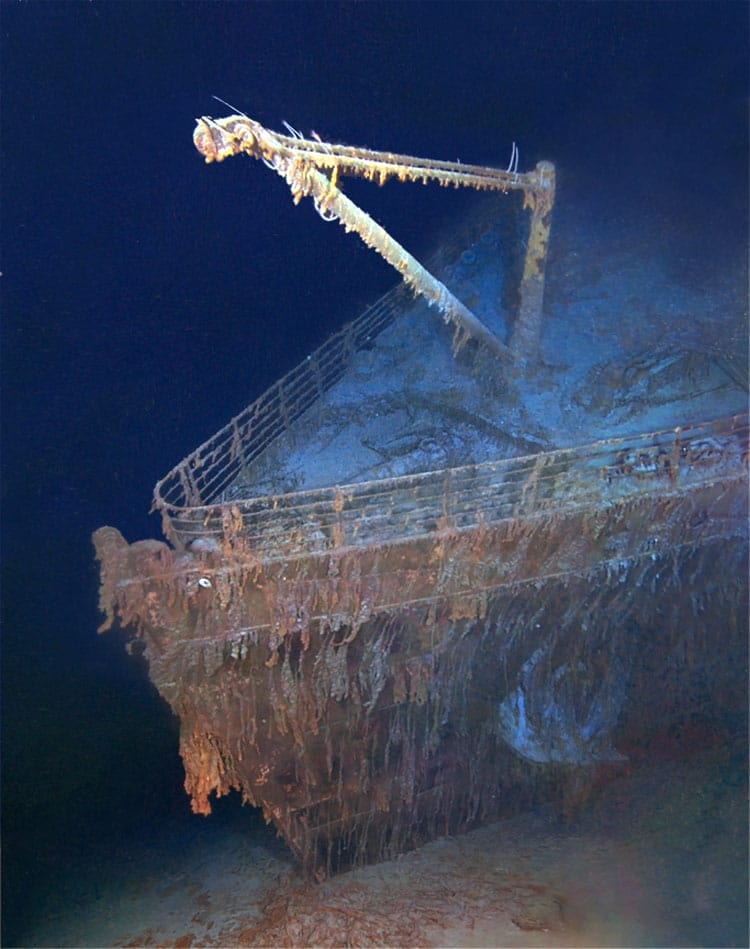
Newly released images of the Titanic wreck site provide the first unrestricted view of the world’s most notable maritime heritage site. These new images add to the already unprecedented collection of images published in the April 2012 issue of National Geographic Magazine. For the first time the public as well as marine archaeologists can view the wreck as if the ocean were removed from the site.
The image mosaics are part of a collection containing over 200 optical mosaics created by the Advanced Imaging and Visualization Laboratory (AIVL) at the Woods Hole Oceanographic Institution (WHOI). The original imagery was collected by WHOI during “Titanic Expedition 2010,” an effort funded by Premier Exhibitions, Inc., the parent company of RMS Titanic, Inc. Post-processing of the optical data was funded by Premier Exhibitions Inc. and the National Geographic Society.
The AIVL, led by Bill Lange, used optical and sonar images collected during the expedition by a specially equipped remotely operated vehicle (ROV) and two autonomous underwater vehicles (AUVs), to stitch together the richly detailed, comprehensive views of the ship and wreck site.
The vehicles carried a combination of sonars used to make wide-area maps and advanced 3-D camera systems used to conduct detailed forensic-type investigations. Although the individual robotic systems provided new information about some pieces of Titanic, the fusion of the imagery provides for the first time a comprehensive view of the wreck site.
“‘Titanic Expedition 2010’ was arguably the most technologically advanced scientific expedition to Titanic,” said expedition organizer Chris Davino, president of RMST, the salvor-in-possession of RMS Titanic and its wreck site. “For RMST, and me personally, this was an incredible opportunity to bring together the leaders in the field of underwater survey and exploration to spectacular effect.”
In addition to AIVL, participants in the expedition included WHOI’s Ocean Systems Lab, led by Gregory Packard, which operated the two REMUS 6000 AUVs; archaeologists from the National Oceanographic and Atmospheric Administration (NOAA) and the National Park Service (NPS); and representatives from the Waitt Institute, owner of the two REMUS AUVs. WHOI Director of Special Projects David Gallo was co-expedition leader along with P.H. Nargeolet of RMST.
“Until now some of the most memorable images we had of Titanic were created by acclaimed artist Ken Marschall,” said Gallo. “Ken’s paintings are fantastic, but we finally have the technologies and techniques to see the Titanic wreck site as it really is, in its entirety and in the context of the surrounding seascape. Even though our mission was scientific—to create the first archaeological map of Titanic—the results have attracted immediate public interest across the globe. It’s very rewarding.”
“Titanic has been a great driver and motivator for imaging, lighting and telemetry technologies in the deep sea,” said Lange, director of WHOI’s AIVL. Lange was a member of the 1985 and 1986 WHOI teams that first discovered and explored the wreck. “There’s no doubt in my mind that the public’s interest in Titanic helped propel the development of many of the technologies we use to explore the deep sea today.”
From the data collected at sea, the AIVL stitched together more than 250 individual mosaics to complete this comprehensive view of the ship and of the many thousands of objects in the surrounding wreck site. “Collecting the information at sea was challenging, but land-based processing of all of the data into useful information was equally challenging,” said Lange.
The work contributes to an effort by NOAA and NPS, two U.S. governmental agencies developing a “site formation plan” to tell the story of how the ship broke apart and where pieces of the ship fell to the seafloor. It is part of RMST’s overarching effort to advance ongoing efforts to preserve the wreck site as a cultural heritage site.
In their first mission, the two REMUS AUVs used side-looking sonar to define the total extent of the Titanic wreck site in the context of the surrounding seafloor terrain. This initial survey area is approximately 3 by 5 nautical miles—an area about the same size as Manhattan Island. This map was then used to define a tighter work area that focused specifically on the large pieces of Titanic (the bow and stern) and on the many thousands of artifacts that fell to the seafloor as the ship broke up and sank. The REMUS AUVs were then sent into this area—roughly equivalent in size to Midtown Manhattan—to make detailed down-looking maps that would be used to guide subsequent ROV operations.
“We modified a commercial ROV from Phoenix International by reworking the power system, telemetry, lighting, cameras, and flotation system and turned it into probably one of the world’s best underwater, close-up, optical survey vehicles,” said Lange.
The Titanic wreck site now represents perhaps the best-surveyed part of the world’s deep ocean. Using digital data, views extend from surface data collected by a satellite to the detailed underwater data that can resolve a teacup or the filaments on a crab’s leg.
Aside from the public fascination with Titanic, the mapping and science is required in order to best understand how to manage the wreck site. By comparing the data collected in 1985 and 1986, for example, the 2010 images and data will help provide a detailed picture of the condition of the wreck and its rate of deterioration over time. In addition, scientists can study the marine animals that have made the ship’s hull their home to better understand how deep-sea ecosystems develop and evolve.
“There are very few places on the bottom of the ocean that we have a 25-year history of what’s happened there, and this study will help scientists and others understand the long term fate of wrecks,” said Lange. “Having a better understanding of the conditions and long-term changes that can occur to these shipwrecks from corrosion, microbial activity, and the pressure in the deep sea will give policymakers and environmental managers the tools and data they need.”
“We are proud that our long experience in the deep ocean has been able to contribute so much to uncovering the full story of Titanic. For us, this has been an important opportunity to show how our advanced technical, imaging, and operations capabilities can combine effectively, whether for scientific, environmental, forensic, or historical purposes,” said WHOI President and Director Susan Avery.
Many of the images including the map, are a direct output of “Titanic Expedition 2010.” RMS Titanic will be adding both still images and interactive applications of the work done by WHOI to its touring exhibits, “Titanic: The Artifact Exhibition.” A full list of cities where these mosaics and more exclusive content from the most recent expedition will be on display is available online at www.rmstitanic.net.
Samuel Weiser, CEO and President of Premier Exhibitions, Inc. noted, “The contribution of Bill Lange’s and Greg Packard’s teams at WHOI have provided RMS Titanic, Inc. with provocative and engaging new content for our “Titanic: The Artifact Exhibition” exhibits and we are currently adding these features to enhance the story we tell of Titanic.”
While the April issue of National Geographic is on newsstands, a selection of the photo-mosaics are available for print and online use by contacting Carol King Woodward at National Geographic (ckingwoo@ngs.org).
About Woods Hole Oceanographic Institution
The Woods Hole Oceanographic Institution is a private, non-profit organization on Cape Cod, Mass., dedicated to marine research, engineering, and higher education. Established in 1930 on a recommendation from the National Academy of Sciences, its primary mission is to understand the oceans and their interaction with the Earth as a whole, and to communicate a basic understanding of the oceans’ role in the changing global environment. For more information, please visit www.whoi.edu.
About RMS Titanic, Inc.
RMS Titanic, Inc., a wholly owned subsidiary of Premier Exhibitions, Inc., is the only company permitted by law to recover objects from the wreck of Titanic. The company was granted salvor-in-possession rights to the wreck of Titanic by a United States federal court in 1994. Premier Exhibitions, Inc. located in Atlanta, GA is a leading provider of museum quality exhibitions throughout the world. Premier is a recognized leader in developing and displaying unique exhibitions for education and entertainment including “Titanic: The Artifact Exhibition.” More information about Premier Exhibitions, Inc. is available at the company’s website www.prxi.com and www.RMSTitanic.net.
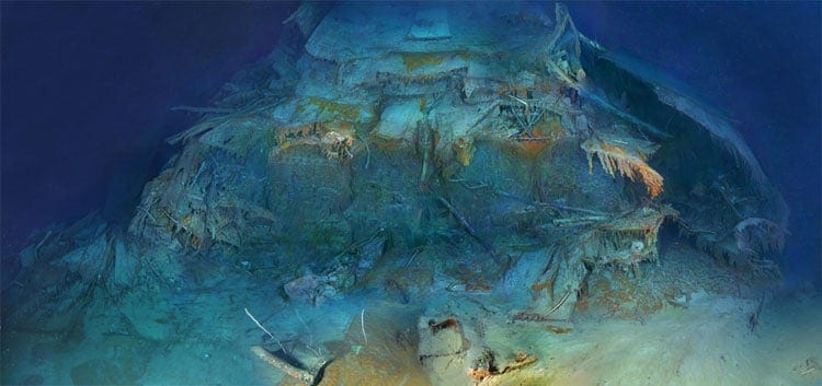
Wide-angle depictions of the Titanic have previously been limited to artists' interpretations. This oblique view is comprised of hundreds of images that were stitched together. Post processing of the optical data was funded by Premier Exhibitions Inc. and the National Geographic Society. (copyright 2012 RMS Titanic, Inc. Produced by AIVL, WHOI)
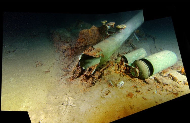
This part of the ship had not been documented prior to the RMST-organized 2010 expedition. The unprecedented view shows the five double-ended boilers that are still in place in boiler room #2. Post processing of the optical data was funded by Premier Exhibitions Inc. and the National Geographic Society. (copyright 2012 RMS Titanic, Inc. Produced by AIVL, WHOI)
These whistles are the only identifiable remains of the #2 funnel. There were four sets of whistles on the Titanic but only those on the #1 and #2 funnels were operational. The whistles on the #3 and #4 funnels were for aesthetic purposes only. Post processing of the optical data was funded by Premier Exhibitions Inc. and the National Geographic Society. (copyright 2012 RMS Titanic, Inc. Produced by AIVL, WHOI)
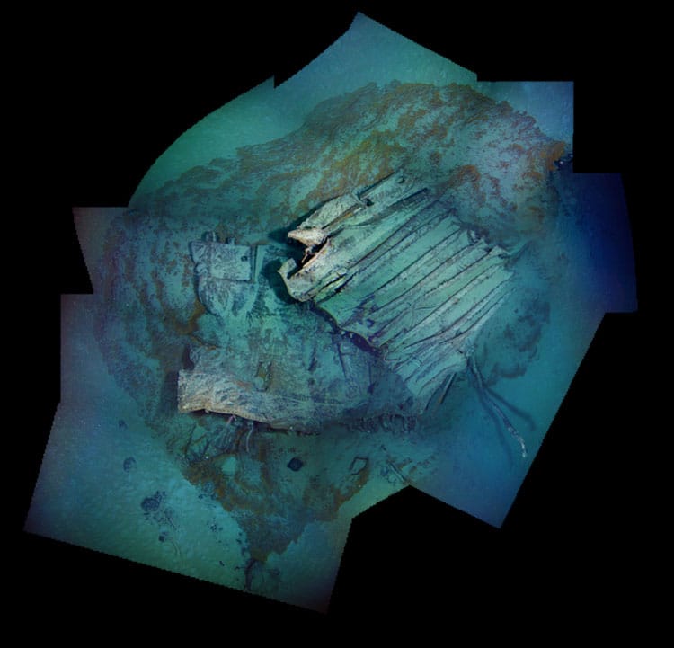
The Titanic artifact field is strewn with unidentified pieces of the ship. This mosaic represents one of the many yet-to-be-identified fragments. Post processing of the optical data was funded by Premier Exhibitions Inc. and the National Geographic Society.
(copyright 2012 RMS Titanic, Inc. Produced by AIVL, WHOI)