WHOI-Operated ROV Jason Images the Discovery of the Deepest Explosive Eruption on the Sea Floor
December 17, 2009
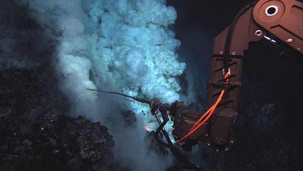
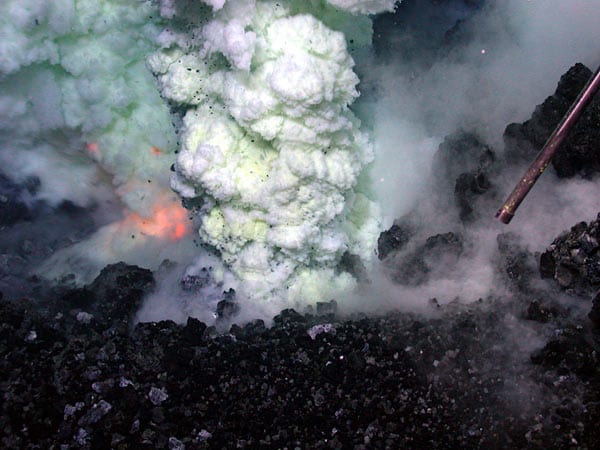
Oceanographers using the remotely operated vehicle (ROV) Jason discovered and recorded the first video and still images of a deep-sea volcano actively erupting molten lava on the seafloor.
Jason, designed and operated by the Woods Hole Oceanographic Institution for the National Deep Submergence Facility, utilized a prototype, high-definition still and video camera to capture the powerful event nearly 4,000 feet below the surface of the Pacific Ocean, in an area bounded by Fiji, Tonga and Samoa.
“I felt immense satisfaction at being able to bring [the science team] the virtual presence that Jason provides,” says Jason expedition leader Alberto (Tito) Collasius Jr., who remotely piloted the ROV over the seafloor. “There were fifteen exuberant scientists in the control van who all felt like they hit a home run. “
Collasius led a team that operated the unmanned, tethered vehicle from a control van on the research vessel and used a joystick to “fly” Jason over the seafloor to within 10 feet of the erupting volcano. Its two robotic arms collected samples of rocks, hot spring waters, microbes, and macro biological specimens.
Through its fiber optic tether, ROV Jason transmitted-high definition video of the eruption as it was occurring. The unique camera system, developed and operated by the Advanced Imaging and Visualization Lab at WHOI, was installed on Jason for the expedition to acquire high quality imagery of the seafloor. The AIVL designs, develops, and operates high resolution imaging systems for scientific monitoring, survey, and entertainment purposes. AIVL imagery has been used in several IMAX films and hundreds of television programs and documentaries.
The video from the research expedition, which departed Western Samoa aboard the RV Thomas Thompson on May 5, 2009, was shown for the first time today at the American Geophysical Union fall meeting in San Francisco.
“Less than 24 hours after leaving port, we located the ongoing eruption and observed, for the first time, molten lava flowing across the deep-ocean seafloor, glowing bubbles three feet across, and explosions of volcanic rock,” reported Joe Resing, a chemical oceanographer at the University of Washington and NOAA, and chief scientist on the NOAA- and National Science Foundation-funded expedition.
For more than a decade, monitoring systems have allowed scientists to listen for seafloor eruptions but there has always been a time lag between hearing an eruption and assembling a team and a research vessel to see it. This has meant that scientists have always observed eruptions after the fact.
“We saw a lot of interesting phenomena, but we never saw an eruption because it happens so quickly,” said Robert Embley, a NOAA PMEL marine geologist and co-chief scientist on the expedition. “As geologists, you want to see the process in action. You learn a lot more about it watching the process.”
The scientists involved in the expedition had praise for the people and the technology that helped bring that dream to fruition.
“I don’t think there are too many systems in the world that could do what Jason does,” said Embley. “It takes a good vehicle, but a great group of experienced people to get close [to an eruption], hold station, and have the wisdom to understand what they can and cannot do.”
The Jason team maneuvered the vehicle to give scientists an up-close view of the glowing red vents explosively ejecting lava into the sea – often not more than a few feet away from the exploding lava – and the ability to take samples.
Enhancing the experience was the ability to view the eruption in high-definition video. Designed to operate at depths of up to 7,000 meters, the unique still and video camera system acquired 30-60 still images per second, at the same time generating motion, high def video at 30 frames per second. The system uses a high-definition zoom lens – nearly twice the focal length of Jason’s present standard definition camera — that enables researchers to see up-close details of underwater areas of interest that they otherwise could not see.
“We were lucky to have those cameras on the vehicle. They are important to the science,” said Tim Shank, a WHOI macro-biologist on the expedition. “We use the high def cameras to try to identify species. They allow us to look at the morphology of the animals — some smaller than 3 or 4 inches long.”
“In terms of understanding how the volcano is erupting, the high frame rate lets you stop the motion and look to see what is happening,” said Resing. “You can see the processes better.”
The National Science Foundation funded the installation of the camera system for this expedition. The system is being tested in advance of a permanent upgrade in 2010 to the cameras on Jason as well as the manned submersible Alvin. Maryann Keith, of WHOI’s AIVL, Shank, and other scientists operated the camera system with the assistance of the Jason team during the expedition.
In addition to the benefits to science, the cameras will serve the added purpose of giving the public more access to seafloor discoveries.
“Seeing an eruption in high definition video for the first time really brings it home for all of us, when we can see for ourselves the very exciting things happening on our planet, that we know so little about,” Embley said.
The Woods Hole Oceanographic Institution is a private, independent organization in Falmouth, Mass., dedicated to marine research, engineering, and higher education. Established in 1930 on a recommendation from the National Academy of Sciences, its primary mission is to understand the oceans and their interaction with the Earth as a whole, and to communicate a basic understanding of the oceans’ role in the changing global environment.


