
High Resolution Imagery Advances the Ability to Monitor Decadal Changes in Emperor Penguin Populations
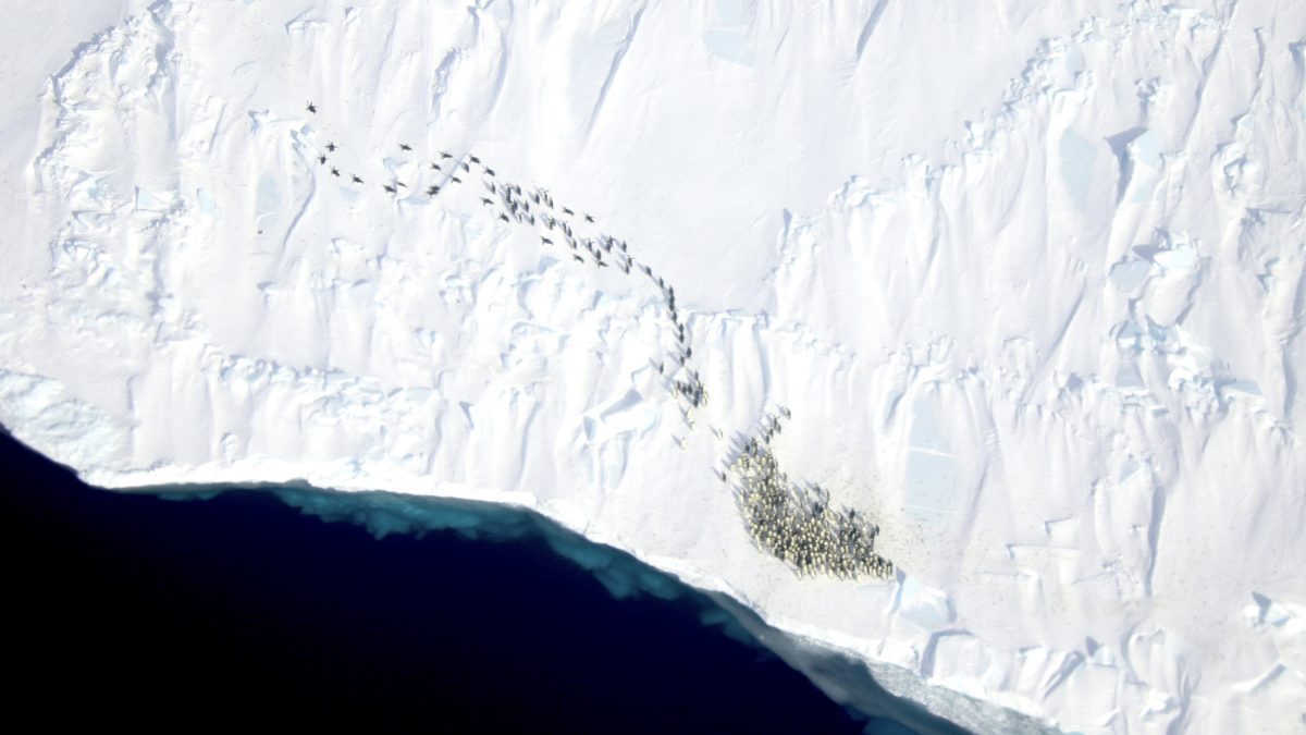 A new study by WHOI researchers and international partners incorporates very high resolution satellite imagery with field surveys and long term date to provide the first multi-year time series documenting emperor penguins global population trends. (Photo by: Sara Labrousse)
 March 13, 2024
Woods Hole, Mass. - Emperor penguin populations have been exceedingly difficult to monitor because of their remote locations, and because individuals form breeding colonies on seasonal sea ice fastened to land (known as fast ice) during the dark and cold Antarctic winter.
Now, new research that incorporates very high resolution (VHR) satellite imagery with field-based validation surveys and long-term data has provided the first multi-year time series that documents emperor penguin global population trends.
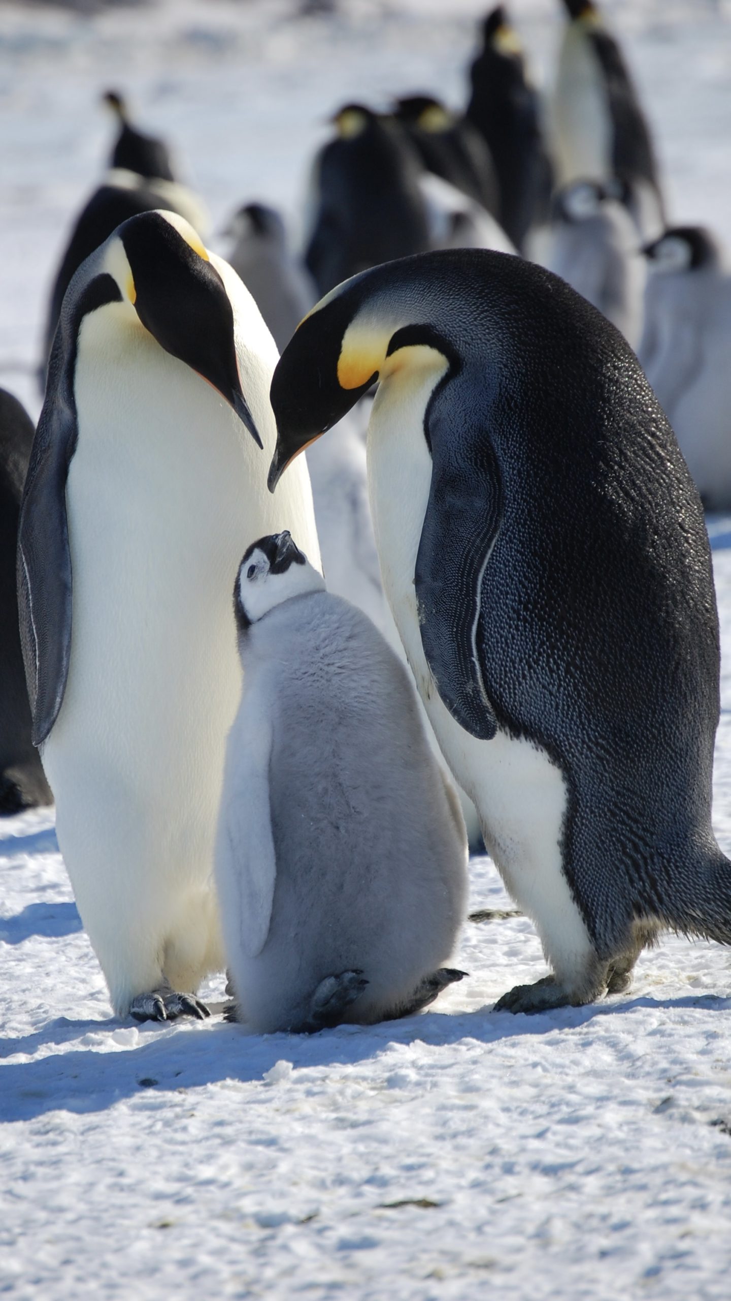
A new study by WHOI researchers and international partners report nearly 10 percent fewer emperor penguins over the nine year study. (Photo by: Jean Pennycook)
Researchers observed nearly 10% fewer birds in 2018 compared with in 2009, according to a new study that used VHR satellite imagery with 30–60-centimeter ground resolution to examine the entirety of the penguins’ range during springtime around the Antarctic coast. The research appears in the journal article, “Advances in remote sensing of emperor penguins: first multi-year time series documenting trends in the global population,” published in the journal Proceedings of the Royal Society B.
Scientists cannot yet explain the population trend. However, additional research should help with a better understanding of the causal factors – including the role of climate change. Further, this new monitoring methodology could help in the development of adaptive conservation management efforts.
“What we did in this paper, and through international collaborative research, was to develop the state-of-the-art approach to monitoring emperor penguins across all of Antarctica, including in remote places that are inhospitable to people. Having the very high resolution satellite imagery is a breakthrough in our understanding of the spatial distribution of emperor penguins, and having this global population trend is very important for conservation,” said journal article senior author Stephanie Jenouvrier, senior scientist in the Woods Hole Oceanographic Institution’s Biology Department.
Jenouvrier noted that the computer modeling takes into account many processes and uncertainties related to penguin population and life history.
“Although we cannot yet clearly attribute this penguin population trend to any particular mechanism such as climate change, there is an accumulation of evidence that the environment is changing and it does not seem to be an environment where penguins are going to endure,” Jenouvrier explained.
The researchers say that the results from the study gives them the potential to make more informed predictions combining monitoring methods and technologies (e.g., field-based, and remote sensing). They note that these will require evaluation of assumptions regarding observation and data processing errors.
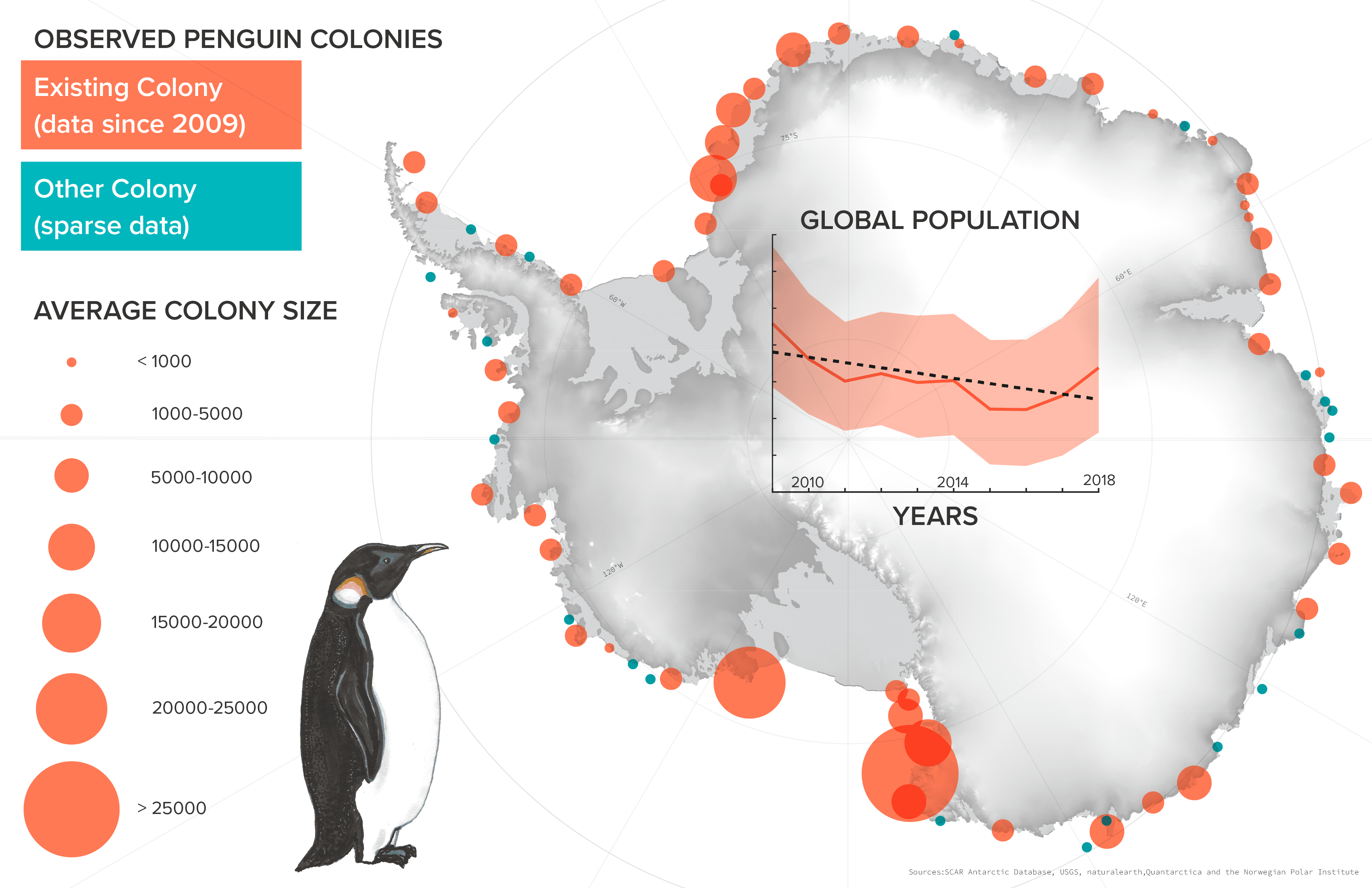
Existing emperor penguin colonies and their average population sizes from 2009 to 2018. The colonies highlighted in red represent those with available population size estimates. Colonies marked in teal are additional locations. The inset displays the index of global abundance of emperor penguins, representing the number of adult birds in attendance at colonies during the springtime, calculated annually. The number of emperor penguins changed from approximately 252,000 birds in attendance during springtime in 2009 to approximately 226,000 birds in 2018. (Graphic by: Natalie Renier, ©Woods Hole Oceanographic Institution)
“Our work documents change in an iconic polar seabird and shows how useful remote sensing can be to understand animals that live in wild places,” according to journal article co-lead author Michelle LaRue, who is an associate professor at University of Canterbury in New Zealand and research associate at the University of Minnesota Twin Cities in the United States. “In a rapidly changing world, we have to constantly push the envelope to combine new approaches with tried-and-true methods if we want to understand the consequences of that change, especially in places we cannot get to.”
LaRue said combining satellite images with animal tracking, ground observations and molecular tools (like genetic analysis) will be needed if they want to fully understand mechanisms to describe some of the changes they observe.
During the course of the study, researchers detected several new colonies, bringing the total to 66 known colony locations. It is now highly probable that most emperor penguin colony locations have been detected, with about half having been detected with satellite imagery, according to the paper.
In addition, the research identified the East Indian Ocean and Weddell Sea areas of Antarctica as being the two sectors of the continent where there is the greatest probability of declines in regional populations of emperor penguins. These are locations where the extent of fast ice generally has decreased in recent decades. Emperor penguins primarily form colonies and rear their chicks on fast ice.
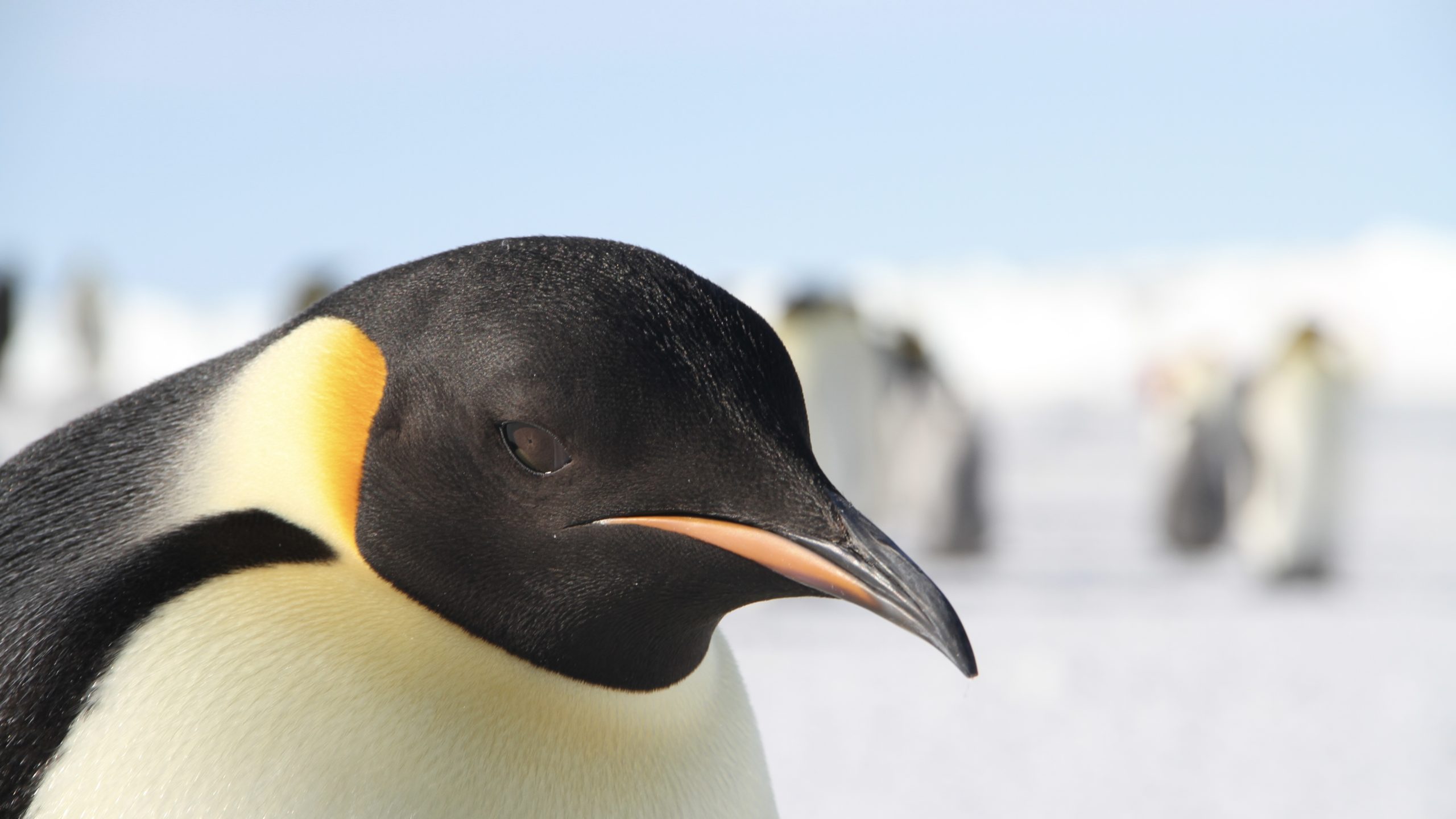
New monitoring methodology could help researchers understand the impact of climate change on the penguins and help in the development of adaptive conservation management efforts. (Photo by Michelle LaRue)
“We don’t understand the population trend in full, and we need to do more research. However, the fact that we have detected a population trend in such a short data set is really important because it potentially has major implications for the future of the species,” said journal article co-author Philip Trathan, an emeritus fellow with the British Antarctic Survey where he previously was head of conservation ecology. “Projections indicate that emperor penguins are going to be struggling to survive into the future. So, having tools that allow us to ground truth some of the population models in the future will be really important.”
The journal article authors said that with this new methodology, there is now a way forward to assess the population status and trends of emperor penguins at a global scale, which provides an invaluable tool for adaptive conservation planning in a changing Southern Ocean.
Funding for this research was provided by the National Science Foundation, NASA; the French Polar Institute Paul-Émile Victor, Alfred Wegener Institute for Polar and Marine Research in the Helmholtz Association, World Wide Fund for Nature (UK), and the German Research Foundation.
High resolution images available here
###
Authors:
Michelle LaRue1,2*†, David Iles3,4†, Sara Labrousse1,4,5, Peter Fretwell6, David Ortega1, Eileen Devane4, Isabella Horstmann4, Lise Viollat4, Rose Foster-Dyer2, Céline Le Bohec7,8 ,Daniel Zitterbart4,9, Aymeric Houstin7,8,9, Sebastian Richter9, Alexander Winterl9, Barbara Wienecke10, Leo Salas11, Monique Nixon2, Christophe Barbraud12, Gerald Kooyman13, Paul Ponganis13, David Ainley14, Philip Trathan6,15, Stephanie Jenouvrier4
Affiliations:
1Department of Earth and Environmental Science, University of Minnesota; Minneapolis, USA
2School of Earth and Environment, University of Canterbury; Christchurch, NZ
3Canadian Wildlife Service, Environment and Climate Change Canada, Ottawa, Canada
4Woods Hole Oceanographic Institution, Woods Hole, Massachusetts, USA
5Sorbonne Université, LOCEAN-IPSL, Paris, France
6British Antarctic Survey, Cambridge, UK
7Centre National de la Recherche Scientifique, Université de Strasbourg, Strasbourg, France
8Centre Scientifique de Monaco, Département de Biologie Polaire, Monaco City, Monaco
9Friedrich-Alexander University Erlangen-Nürnberg, Department of Physics, Erlangen, Germany
10Department of Climate Change, Energy, the Environment and Water, Australian Antarctic Division, Hobart, Australia
11Point Blue Conservation Science, Petaluma, USA
12Centre d’Etudes Biologiques de Chizé, Centre National de la Recherche Scientifique – La Rochelle Université, France
13Scripps Institution of Oceanography, La Jolla, USA
14 HT Harvey and Associated, Los Gatos, USA
15Ocean and Earth Science, National Oceanography Centre, University of Southampton, Southampton, UK
†Equal first authors
*Corresponding author
About Woods Hole Oceanographic Institution
The Woods Hole Oceanographic Institution (WHOI) is a private, non-profit organization on Cape Cod, Massachusetts, dedicated to marine research, engineering, and higher education. Established in 1930, its primary mission is to understand the ocean and its interaction with the Earth as a whole, and to communicate an understanding of the ocean’s role in the changing global environment. WHOI’s pioneering discoveries stem from an ideal combination of science and engineering—one that has made it one of the most trusted and technically advanced leaders in basic and applied ocean research and exploration anywhere. WHOI is known for its multidisciplinary approach, superior ship operations, and unparalleled deep-sea robotics capabilities. We play a leading role in ocean observation and operate the most extensive suite of data-gathering platforms in the world. Top scientists, engineers, and students collaborate on more than 800 concurrent projects worldwide—both above and below the waves—pushing the boundaries of knowledge and possibility. For more information, please visit www.whoi.edu
Key Takeaways
- Emperor penguin populations have been exceedingly difficult to monitor because of their remote locations, and because individuals form breeding colonies on seasonal sea ice fastened to land (known as fast ice) during the dark and cold Antarctic winter.
- New research that incorporates very high-resolution satellite imagery with field-based validation surveys and long-term data has provided the first multi-year time series that documents emperor penguin global population trends.
- Researchers observed fewer birds in 2018 compared with 2009 according to a new study that used VHR satellite imagery with 30–60-centimeter ground resolution to examine the entirety of the penguins’ range during spring times around the Antarctic coast.
- This new monitoring methodology could help researchers understand the impact of climate change on the penguins and help in the development of adaptive conservation management efforts.