
WHOI Scientists Receive $11.6 Million to Measure Changes in Ocean Circulation
October 18, 2013
Ocean currents, in concert with the atmosphere, play a critical role in regulating Earth’s climate. Yet the complexities of how water is moved around the globe and how the strength and pathways of ocean currents may change in a warming climate are little-understood.
A new five-year project funded by the National Science Foundation will, for the first time, allow scientists to continuously measure the strength and pathways of ocean currents over the entire subpolar region of the North Atlantic, where some of the most important currents come together. Oceanographers from Woods Hole Oceanographic Institution (WHOI) and their colleagues from Duke University and the University of Miami will receive funds to deploy a new observing system to simultaneously monitor the warm, more saline northward-flowing currents and the cold, fresher currents flowing southward in this region.
The initiative is part of the $32 million, U.S.-led Overturning in the Subpolar North Atlantic Program (OSNAP). International collaborators include scientists from Canada, the United Kingdom, Germany, France and the Netherlands.
Amy Bower, a WHOI physical oceanographer and co-principal investigator of the project described Earth’s “overturning circulation” as a complex web of currents traveling around the globe. “Slowly but relentlessly, it carries excess heat from the equator toward the poles, where the heat is transferred to the atmosphere,” she explains. “With contributions of fresher water from precipitation and melting ice at high latitudes, the cooled water sinks toward the ocean bottom and flows back toward the equator, rises, and is warmed again. Understanding the details of this overturning circulation and measuring changes in its strength are high priorities in the international climate and ocean science communities.”
Bower and two other principal investigators from WHOI, Robert Pickart and Fiamma Straneo, will receive $11.6 million and will work with Institution technicians, engineers and ships crew, to build and deploy moorings around Greenland and floats at several sites along the OSNAP transect.
“Greenland’s margins are a great place to take the pulse of the Atlantic overturning circulation in the high latitudes. This is where equatorward-flowing freshwater from the Arctic meets the poleward-flowing warm Atlantic water – and the two are progressively cooled and transformed into denser waters,” says Straneo, a physical oceanographer. “And beneath these waters we can simultaneously observe the equatorward flow of the even denser waters formed in the Nordic Seas.”
Recent modeling studies have shown that a change in strength in the North Atlantic circulation would have a critical impact on temperatures and precipitation in North America, Europe and Africa. In addition to measuring the variability of the ocean overturning, OSNAP is focused on understanding what factors create those changes.
“For decades, oceanographers have understood the overturning circulation to be highly susceptible to changes in the temperature and salinity of surface waters in the subpolar North Atlantic,” says Susan Lozier, the international project lead for OSNAP and a physical oceanographer at Duke’s Nicholas School of the Environment. “With increasing ocean temperatures, and increased ice melt that impacts the salinity of the surface waters, it is timely to establish just how climate changes might affect the strength of the overturning circulation.”
Likewise, the OSNAP array affords the opportunity to study how overturning changes impact the environment. OSNAP measurements will facilitate the study of how changes in the northward flow of warm water affect the reduction of Arctic sea ice and the shrinking of the Greenland Ice Sheet.
WHOI, Duke, and Miami oceanographers, along with their international partners, will deploy moored instruments and sub-surface floats across the subpolar North Atlantic during the summer of 2014 from the R/V Knorr. The initial measurement period will last until 2018. If successful, the scientists hope to extend the measurement period to one decade.
The array of instruments will stretch along two transects, from Labrador to southern Greenland and from Greenland east to Scotland. The instruments will provide the scientists with continuous measurements of surface-to-bottom water temperature, salinity, and velocities in areas of the subpolar ocean that historically have been under-sampled. Trajectories of the subsurface floats will provide the first direct observation of deep-water pathways over the entire northern region of the North Atlantic for the first time–previously these pathways have only been inferred from sparse moored observations and coarse maps of deep water properties.
“We’ll release about 120 so-called RAFOS floats along the OSNAP transect and will track them acoustically for up to three years using an array of 10 moored sound beacons,” says Bower. “The trajectories will aid in the interpretation of changes observed by the moored current meters and temperature/salinity instruments. For example, if we observe a slow-down in currents, the floats will help us figure out if it represents a real slow-down or just a change in current pathways.”
The OSNAP measurement system complements the U.K.-U.S. RAPID/MOCHA program that has been measuring the overturning circulation in the subtropical North Atlantic since 2004. Differences and similarities in the overturning circulation at these two sites will provide oceanographers insight into the workings of the ocean over a large area.
OSNAP will be one of the first projects to make use of the new, NSF-funded Ocean Observatories Initiative’s (OOI) array of moored sensors by taking advantage of data from several OOI moorings to be installed in the Irminger Sea, off the southern tip of Greenland, in 2014. The Irminger Sea is one of four planned global observing sites of the OOI program, an ambitious networked infrastructure of science-driven sensor systems to measure the physical, chemical, geological and biological variables in high-latitude and coastal ocean locations as well as at the seafloor.
In addition to the international collaborations within OSNAP, Straneo will direct an effort to bring together several large projects, scientists and students focused on the North Atlantic in a virtual space where they can interact, exchange ideas and work cooperatively across international boundaries. Called the North Atlantic Virtual InStitute (NAVIS), the effort is part of a larger NSF program called Science Across Virtual Institutes.
The Woods Hole Oceanographic Institution is a private, non-profit organization on Cape Cod, Mass., dedicated to marine research, engineering, and higher education. Established in 1930 on a recommendation from the National Academy of Sciences, its primary mission is to understand the ocean and its interaction with the Earth as a whole, and to communicate a basic understanding of the ocean’s role in the changing global environment. For more information, please visit www.whoi.edu.
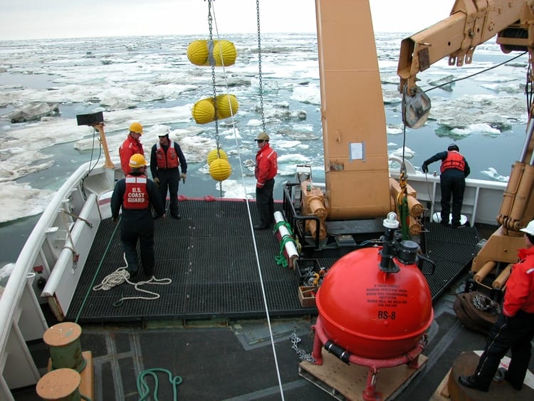
OSNAP scientists will deploy deep ocean moorings, such as shown here, across the subpolar North Atlantic during the summer of 2014, which will provide continuous measurements of surface-to-bottom water temperature, salinity, and velocities in areas of the subpolar ocean that historically have been under-sampled.
(Photo by Chris Linder, Woods Hole Oceanographic Institution)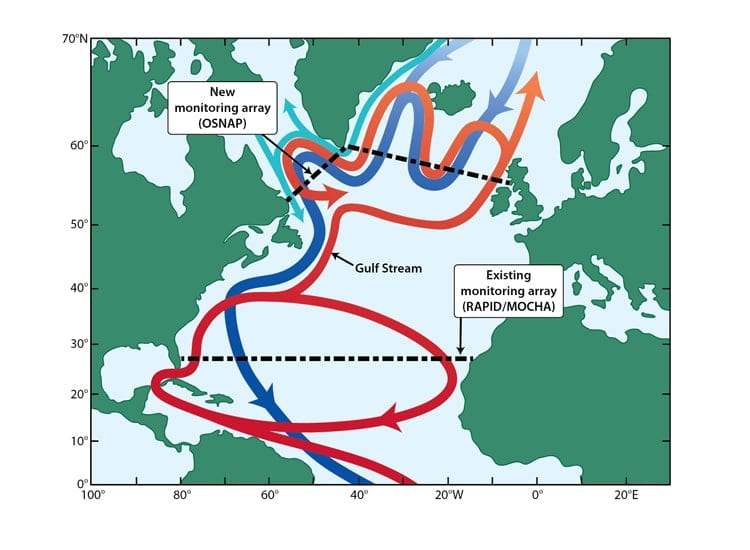
OSNAP deployment location in the North Atlantic. Red arrows show warm water pathways, dark blue indicates cold, deep water pathways and light blue indicates cold, fresh water input from the Arctic. (Illustration by Jack Cook, Woods Hole Oceanographic Institution)
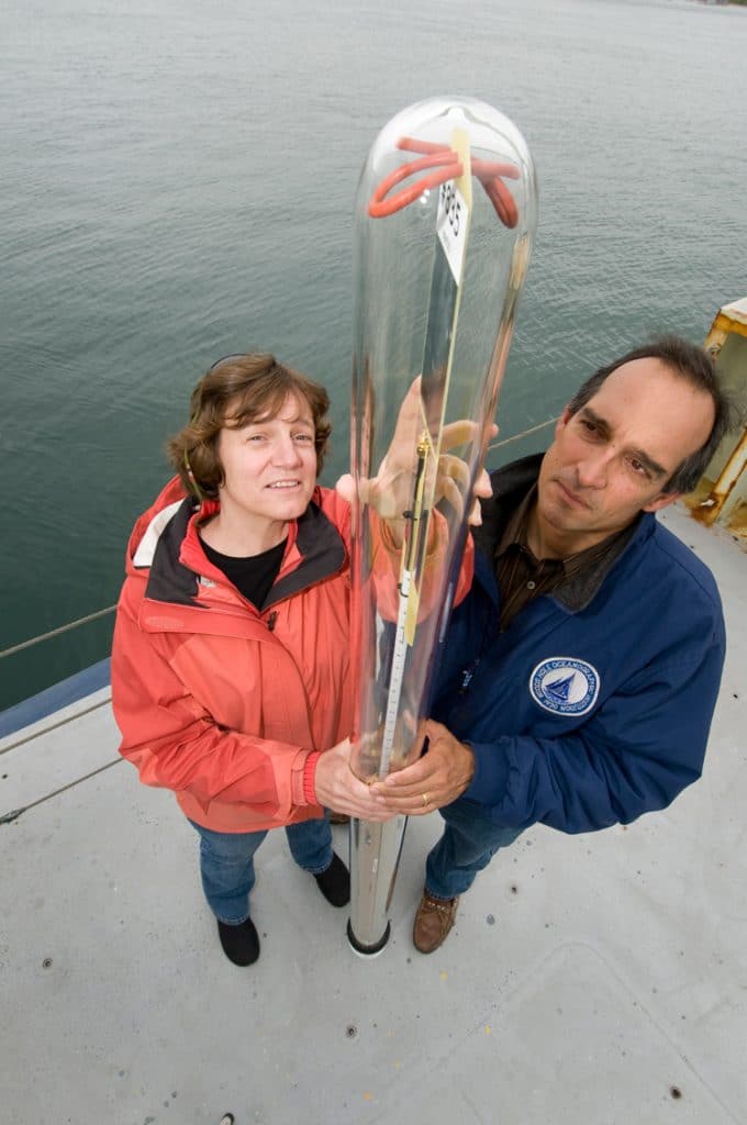
WHOI physical oceanographer Amy Bower, an OSNAP principal investigator, and research associate Dave Fisichella hold a RAFOS float. RAFOS floats are designed to take measurements of temperature, salinity, and pressure in layers of ocean water one to three thousand meters below the surface. More than 100 of these subsurface floats will be deployed as part of OSNAP, and their trajectories will provide scientists with the first look at deep-water pathways in the subpolar North Atlantic.
(Photo by Tom Kleindinst, Woods Hole Oceanographic Institution)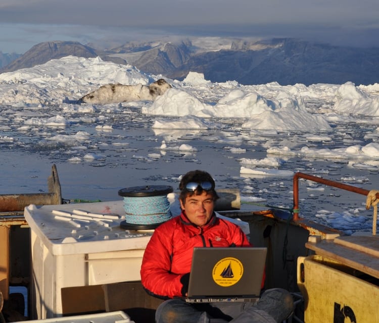
Heading into the summer sun, WHOI physical oceanographer and OSNAP principal investigator Fiamma Straneo reviews data collected in Sermilik Fjord, Greenland, in August 2010. “Greenland’s margins are a great place to take the pulse of the Atlantic overturning circulation in the high latitudes," says Straneo. (Dave Sutherland, Woods Hole Oceanographic Institution)
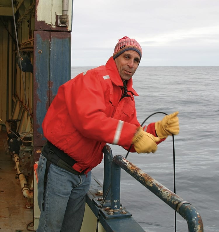
WHOI physical oceanographer Bob Pickart, a veteran of many voyages to high latitudes, is an OSNAP principal investigator. OSNAP will, for the first time, allow scientists to directly measure these ocean pathways over the entire subpolar region of the North Atlantic. (Photo by Dan Torres, Woods Hole Oceanographic Institution)