

Chilly Scenes of Winter off Cape Cod
What happens in the coastal ocean when the winds blow and the waters cool?
When winter winds began rattling the storm windows last autumn, Andrey Shcherbina and Glen Gawarkiewicz shook the mothballs out of their cold-weather exposure suits and dusted off their sea boots. For the second consecutive winter, the two physical oceanographers at Woods Hole Oceanographic Institution (WHOI) and their small team braved rowdy seas to study how winter storms affect the shallow current flowing south through our coastal back yard—parallel to Cape Cod’s extended forearm, from Provincetown to Chatham.
Andrey and Glen aren’t the only ones interested in how the coastal current changes in winter. Ted Ligenza, a Chatham hook fisherman, also wants to know. The cod he chases with his longlines have an affinity for well-mixed winter water. Ted monitored the results of our experiment last winter—in particular, how offshore water temperatures changed from surface to seafloor—by watching our project’s website. Shellfish farmers and state health officials are also keenly interested, because the coastal current controls the movement of dangerous red tide algae around the Cape.
Like the atmosphere with its ever-moving high- and low-pressure systems, the oceans have the equivalent of “undersea weather.” The oceans have masses of relatively colder or saltier water that are denser and sink, or warmer or fresher waters that are more buoyant and rise. These masses continually move and interact to produce a highly energetic environment. Many factors influence the undersea weather. Cold winter air cools the sea surface; precipitation adds fresh water; tides and winds mix things up. Winter storms may do all three, but not many scientists have measured it directly because winter oceanography can be both difficult and costly, involving large ships, long cruises, and big fuel bills.
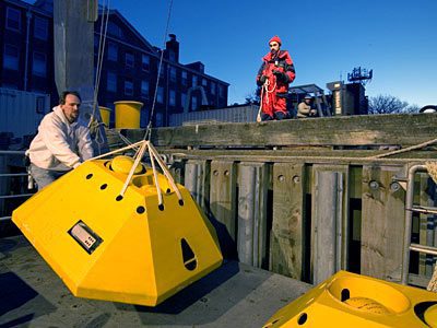
Our mission is to reveal how the Outer Cape water masses’ temperature, salinity, and currents change during the winter. Funded by the WHOI Coastal Ocean Institute and the Woods Hole Sea Grant program, we used a combination of inexpensive, lightweight moored instruments and a sophisticated autonomous swimming vehicle called the REMUS (Remote Environmental Monitoring UnitS). Both were deployed from small, fast boats—when the weather allowed.
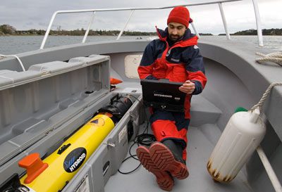 Oct. 10, 2005—A blustery late October morning finds Andrey Shcherbina, Glen Gawarkiewicz, and me at an empty boat landing in Eastham. We’re waiting for Dawson Farber, the harbormaster. He’s going to be taking us out in his boat for a REMUS mission.
Problem is, there are no boats in the water. He arrives right on time with his smaller-than-expected skiff on a trailer. He’s a tall guy, built like a Navy SEAL, wearing a big orange-and-black mustang suit. “Brought your foul-weather gear I hope!” he grins as he loads gear into the tiny open cockpit boat.
I take a look at the sky—dark clouds on the horizon are promising some fun. We suit up and launch the boat. Andrey programs the mission into the REMUS as we glide through the calm waters of Nauset Harbor.
 Oct. 10, 2005—At the shallow break separating bay from open ocean, we hit a wall of heavy swell. After a few minutes of bouncing on the waves, we arrive at the deployment site. We quickly lower the REMUS over the side and send the start signal. Off it goes on its predetermined route eastward, undulating from the surface down to 90 meters (300 feet) to capture a cross-section of temperature, salinity, and current speed and direction.
As we follow the REMUS, the clouds turn a shade more menacing. Dawson keeps checking his gas gauge and his watch, which makes me nervous. Once the clouds start spitting their first raindrops, we send the abort command. We grab the REMUS and beat back to safety with water sheeting over the rails and a storm kicking up all around us.
I’m soaked to the skin when we pull back in to Eastham, but overall, it was a great start to this winter’s work—a nice late fall data section at a fraction of the cost of a day aboard the research vessel Oceanus. And, we’re back at WHOI in time to make the afternoon seminar.
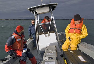
 Dec. 19. 2005—Mooring deployment day finds me shoveling down cereal in the predawn darkness at my house. I grab my thermos, pack up my bags, and drive down to the pier. Today we’re in the hands of Ken Houtler (left), captain of WHOI’s coastal research vessel Tioga, and crewman Ian Hanley. We load up the equipment by the glow of the Tioga’s floodlights. A frosty wind tears at our faces, so I put on the foul-weather “mustang” suit before we even leave the pier. We slip away into black waves before 7 a.m. It’s a three-hour transit to our working area east of Cape Cod. On the way there, I try to get some sleep in one of the bunks but am getting serious air time with every wave we hit. Not super relaxing.
 Dec. 19. 2005—WHOI Engineer Craig Marquette (hands), Andrey (left), Glen, Ian (right), and I assemble the small moorings on the heaving fantail, pay them out the back, and push them into the cold water. We tie-wrapped the tiny temperature-measuring loggers on the lines at WHOI beforehand. Craig says it best: “Now it’s all grunt work.” Attach float to mooring line. Throw float over the side. Pay out line. Pay out chain. Push over the anchor. Repeat.
I do most of the work on my knees so that I can better maintain my balance. By 3 p.m., the sun is sinking low on the horizon. All of the moorings—six lightweight temperature logger strings and two bottom-mounted instrument cages—are safely at sea with no mishaps; a very good day.
Everyone keeps asking where I got my tan. I think it’s actually windburn.
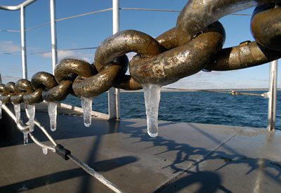 Dec. 21, 2005—Winter solstice, the shortest day of the year. It’s pitch black when we pull into the parking lot and load the coffin-sized REMUS case onto Tioga. The light from Nobska Lighthouse winks goodbye as we accelerate away from Woods Hole. When we arrive at the mission’s start point, the sun has just broken the horizon. Dripping seawater has frozen into icicles on the anchor chain.
The REMUS collects data while we hunker down out of the wind behind the pilot house. The sun is back down before we hit the pier. We’re the science vampires—leaving in the dark, returning in the dark, carrying a heavy coffin full of data sucked from the sea.
 Jan. 20, 2006—The holidays have passed and with them a few more storms. We have returned for more data to add to our picture of the evolving winter oceanography.
Finding a weather window for our work has been a challenge. We watch the forecast, trying to guess how it will change before we arrive at the pier. Waiting for acceptable conditions—winds at or below 15 knots and seas under 6 feet—has been frustrating. After a hurried meeting, Glen makes the call: “Marginal is better than nothing, let’s go for it.” On this particular January day, the light aluminum Tiogabobs corklike on the northeasterly swell.
I can see the exhaustion written on everyone’s faces. We deploy the REMUS and turn on the acoustic tracking. Our routine is now familiar: We take turns lowering the small fishlike tracking device into the water, then we wait for the vehicle to send us its status. After confirming the vehicle is on track, we pull the “fish” back onboard and head off to the next location.
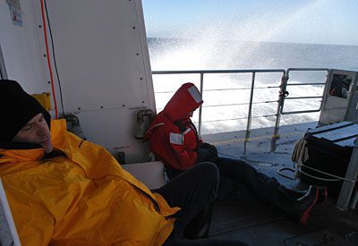
We’re battered and bruised from trying (unsuccessfully) to keep our footing on the pitching deck. The seasickness medication makes me a walking zombie. By midday, we’re all catnapping on the transits, lulled by the throbbing bass of Tioga’s engines. Rainbows—probably the last thing I’d expect to see on a day like this—form in the white water flying over the rail.
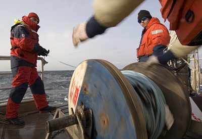
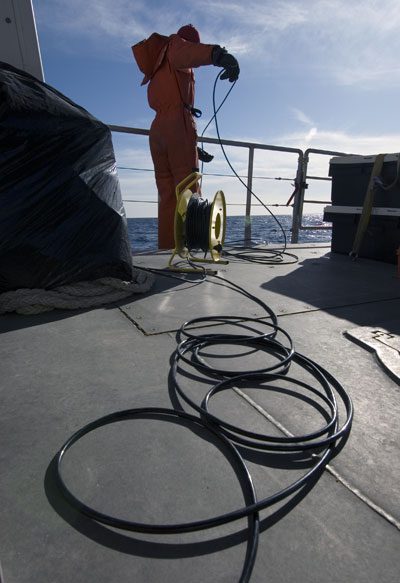
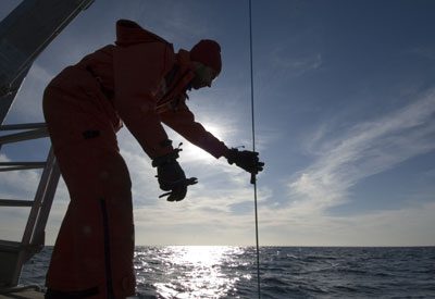
 Feb. 21, 2006—The weather looks great in this photo—clear blue skies—but the mustang suits tell the real story. The air is freezing and the cold water from the wet mooring lines has soaked through my gloves. We can see our breath when the wind isn’t ripping it out of our lungs. The physical labor keeps our minds from seasickness.
The previous winter two entire mooring chains were mysteriously lost, so it is a relief when we find that all six of the temperature moorings are right where we left them three months ago. Only two moorings, the bottom-mounted cages, remain.
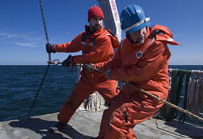
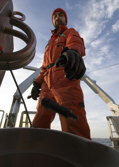
 Feb. 21, 2006—“OK, one more time,” Craig signals to Andrey to lower the acoustic transponder over the side. It sends a coded acoustic signal to the bottom-mounted moorings with an Acoustical Doppler Current Profiler (ADCP). The moorings are programmed to release a float attached to a line. Then we haul the line and instruments aboard. The problem is, one of the moorings isn’t answering. After circling the spot for an hour with no communication from the mooring, we give up for the day.
 Feb. 21, 2006—Andrey unclips the temperature loggers from the mooring lines while Ian pulls them up with the winch. Only the uppermost loggers have been lost. “Must have been some abrasion with the surface float,” Andrey speculates as he unclips another logger.
 Feb. 21, 2006—Andrey drops loggers full of data into a bucket. Each one of the precious loggers holds a winter’s worth of data on water temperatures. We thought we were suffering, but the moorings weathered some real storms while we were back in the office.
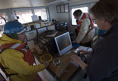
March 24, 2006—Andrey is on the phone with Greg Packard, REMUS expert from the WHOI Applied Ocean Physics and Engineering Department, getting some technical advice at sea. Glen (center) and Jen Hua Tai, a visiting student from Taiwan (blue jacket) watch expectantly to see if data from a sidescan sonar will reveal the location of the missing ADCP mooring. “Wave ripples, sandy bottom,” Andrey declares as he scans the images. Of the lost mooring, there isn’t a trace.
 March 24, 2006—WHOI Engineer Tito Collasius drives the controls on a remotely operated vehicle, panning around with the vehicle’s camera to look for the missing mooring. Craig (left) watches the monitor. Jonathan Borden of the U.S. Geological Survey is in the background.
“This current is too strong to anchor. I’ll have to keep her in position using the engines,” Captain Ken Houtler explains. After a full day of searching, we give up on the missing mooring. It’s possible that a scallop trawler snagged it and dragged it far out to sea.
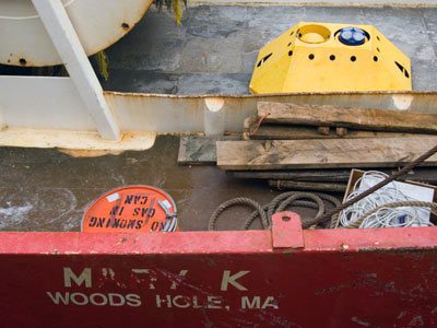 Postscript: As I was typing the last caption for this article, Craig Marquette received an unexpected phone call. It was Henrique Franco, the skipper of the fishing vessel Mary K, calling to say that he had caught a large yellow object in his nets while fishing off Chatham on July 8. Once the Mary K pulled into port, Andrey and I drove over to New Bedford to retrieve our missing mooring. While only a portion of the data could be recovered from the cod-scented instruments, it was still a relief to get them back. This summer we will be piecing together the story of winter beneath the waves and drying out the survival suits for next winter’s adventures.