Where the Surf Meets the Turf
Scientists explore coastal processes that affect beaches
January 2000 — The gentle lapping of waves on the beach is a metaphor for enduring tranquility. However, the thin zone where the surf meets the turf is one of the most turbulent, complex, fast-moving, constantly changing places on Earth. The nearshore region (between the dry land above the beach and the relatively deep water in the coastal ocean) is continually subjected to large waves, strong winds, and vigorous currents that stir up and transport massive amounts of sand—creating and destroying dunes on the beach and sandbars in the surf, or changing their shapes and positions. Shifting sandbars, in turn, change the topography of the seafloor, altering the direction of currents and causing waves to break in different locations with varying intensities. Thus, changes in one variable affect many others in nearshore systems. In the process, sand is taken from some beaches and given to others, or the same beach is alternately eroded or built up at different times.
Unraveling the physics of these nearshore processes offers valuable societal benefits. More than half the world’s population lives within 100 miles of the coast. More than $2 billion is spent annually to restore eroded beaches and to build jetties, breakwaters, and other structures that may prevent erosion and protect property. Beaches also have military importance, serving as strategic landing zones. With dual goals of safeguarding civilian property and supporting military operations, the Army Corps of Engineers has established facilities to conduct research and testing. Among these is the Field Research Facility (FRF), a former Navy bombing range on a 176-acre beach site in Duck, North Carolina, which the Army Corps converted into a unique natural laboratory to study nearshore processes. Its primary mission is to collect measurements of waves, currents, winds, tides, sand levels, and other phenomena in an effort to improve understanding of the processes that affect beaches. Although scientists can learn a great deal from laboratory experiments, theoretical studies, and computer simulations, they need field measurements to test the results of these studies and to determine the relative importance of various processes on natural beaches. However, large waves and evolving conditions make it difficult to install and maintain instruments, particularly during Nor’easter storms and hurricanes when the most dramatic beach changes occur.
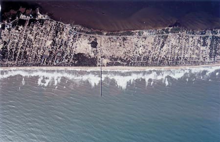
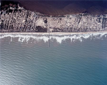
For the past 20 years most of the large US nearshore field experiments have been conducted at the FRF. Scientists from around the world, including several from WHOI, have come to Duck to do research, attracted by the FRF’s specialized equipment, experienced staff, and unique capabilities. The 3,000 feet of waterfront is bisected by a 1,840-foot pier extending from the dunes on the beach to water depths of about 23 feet. A cranelike device mounted on railroad tracks along the pier, called a Sensor Insertion System (SIS), can deploy instruments in precise locations in the ocean up to 75 feet on either side of the pier.
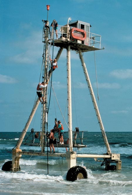
The FRF also offers specialized vehicles, including the Lighter Amphibious Resupply Cargo (LARC) ship, which can be loaded on shore and driven through the surf into deeper water, and the Coastal Research Amphibious Buggy (CRAB), a motorized, three-wheeled vehicle with a stable platform atop a 35-foot tripod frame (photo at left). The CRAB can be driven from the beach into the ocean, in wave heights up to six feet, to install and service instruments, to collect sediment samples, and to map the ocean bottom.
Observations are collected continuously with permanent instruments, providing a long-term, ever-growing data set of coastal changes. A waverider buoy located approximately a mile offshore of the FRF and pressure sensors in shallow waters are used to study the evolution of waves traveling from the deep coastal waters across the surf zone to the shoreline where they run up the beach. A tide gauge at the pier end measures fluctuating tidal elevations that are important to nearshore processes. Multiple video cameras mounted on a 140-foot-tall tower on shore record breaking waves and shifting sandbar locations. Changing sand levels from the beach out to 26-foot water depths are surveyed with the CRAB. Air temperature, atmospheric pressure, rainfall, winds, and other meteorological data are measured routinely. These data have been used, for example, by WHOI Associate Scientist Jim Edson and FRF Research Oceanographer Chuck Long to study interactions and exchanges between the air and ocean.
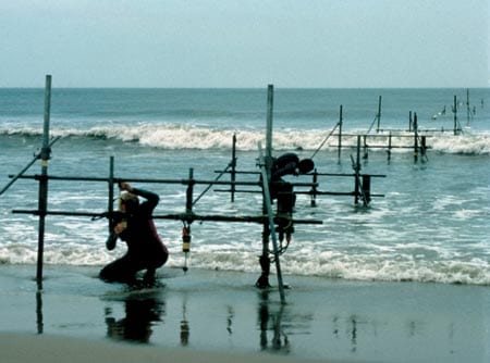
The FRF’s continuous, long-term observations have been complemented by short, intense experiments. In 1994, scientists from many institutions convened at Duck to conduct an ambitious experiment to study the surf zone. Author Steve Elgar, now a Senior Scientist at WHOI, and Bob Guza of the Scripps Institution of Oceanography (SIO) used the CRAB and the LARC to deploy several metalpipe scaffolds, each supported on six 20-foot-long, metal-posts inserted into the seafloor. Mounted on the scaffolds, which were located at intervals between the beach and 25-foot water depths, were current meters to measure the speed and direction of currents, sonar devices that use sound to record the changing seafloor topography, and pressure sensors that measure waves and water levels by measuring the weight of water above them.
With this instrument array, Elgar, Guza, and Edith Gallagher of the Naval Postgraduate School documented how offshore-directed currents (undertow) moved sandbars out to sea during storms. In one case, storm-related undertows moved a six-foot high sandbar about 100 yards seaward.
Combining observations from the surf zone array with measurements from the FRF’s permanent sensors, WHOI Associate Scientist Steve Lentz and author Britt Raubenheimer, now an Assistant Scientist at WHOI, showed that breaking waves cause mean water levels to increase by more than a foot in the surf zone. Using instruments deployed farther offshore, Lentz determined the relative effects of breaking waves, winds, and the earth’s rotation on ocean circulation on the inner continental shelf. WHOI Senior Scientist and biological oceanographer Cheryl Ann Butman showed that wind-driven currents controlled the onshore and offshore transport of clam, snail, and worm larvae.
Building on what was learned during Duck94, FRF conducted an even larger experiment during fall 1997. More than 250 scientists, technicians, students, divers, and others deployed over 400 sensors. Using the CRAB, the authors and Guza installed more than 200 sensors to measure waves, circulation, water table fluctuations, and changing sand levels. WHOI Associate Scientist John Trowbridge investigated bottom stress associated with breaking waves and wind-driven currents using instruments mounted on a 1,000-pound frame deployed with the CRAB. Additional sensors deployed by other investigators included scanning acoustic altimeters to map the movement of ripples on the seafloor, and fiber-optic backscatter sensors to measure the amount of sand suspended and transported in the water above the seafloor. Frequent sand samples were collected from the CRAB and by divers to determine sediment grain sizes, which affect the amount of sand that can be lifted off the bottom and moved by waves and currents. The more details we learn about nearshore physics, the more we will be able to elucidate the mechanisms that cause erosion or coastal damage, and begin to predict and prevent them. The fundamental physics learned at Duck is applicable to many beaches around the world that have similar characteristics and wave conditions. The FRF has established a beachhead of knowledge to solve problems that once seemed too complex to grasp.
Information on the FRF is available at: www.frf.usace.army.mil. The authors thank William Birkemeier, director of the Field Research Facility, and WHOI Senior Scientist Cheryl Ann Butman, who provided helpful comments. The Office of Naval Research, the National Science Foundation, and the Army Research Office have supported our research.
Slideshow
Slideshow
 An 1,840- foot pier bisects 3,000 feet of beachfront at the Army Corps of Engineers' Field Research Facility in Duck, N.C., where scientists explore coastal processes that affect beaches.
- Scientists and divers set up a series of metal-pipe scaffolds at intervals from the beach out into the ocean. Instruments mounted on the scaffolds collect data on currents, waves, seafloor topography, and other phenomena to unravel the complex forces that shape coastal areas. (William Birkemeier. )
- Among the specialized equipment at the Army Corps of Engineers' Field Research Facility is a motorized, threewheeled vehicle with a stable platform atop a 35-foot tripod frame. The Coastal Research Amphibious Buggy, or CRAB, can be driven from the beach into the ocean, in wave heights up to six feet, to install and service instruments, to collect sediment samples, or to map the ocean bottom. (William Birkemeier.)
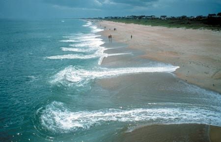
- Waves, currents, sand grain sizes, sandbar configurations, water table levels beneath the beach, and other phenomena combine in complex ways, causing very different patterns along the same beach. (Photo by Steve Elgar, Woods Hole Oceanographiuc Institution)
Related Articles
- An introduction to marsh bothering
- Wilmington’s shark tooth divers can thank the last ice age for their treasure trove
- Novel tool sheds light on coral reef erosion
- With worsening storms, can the Outer Banks protect its shoreline?
- Dune buggies and diving:
- Adapt or retreat:
- The ocean science-art connection
- Marshes, Mosquitoes, and Sea Level Rise
- More Floods & Higher Sea Levels

