“What a Year!”
WHOI's Deep Submergence Lab Brings Together Four Technologies to Serve Three Diverse Expeditions
Four technologies that have been developing separately for some time were brought together this year by WHOI’s Deep Submergence Laboratory (DSL) to serve three very different user communities. With images from the towed vehicle Argo II and the remotely operated vehicle Jason, DSL scientists and engineers created mosaic images of a sunken British cargo ship and 20-meter-tall hydrothermal vent chimneys, both in the Pacific Ocean, and ancient shipwreck sites in the Mediterranean. The three expeditions thus served the marine safety, scientific, and archaeological communities.
The four technologies are precision navigation, automatic control or dynamic positioning of the vehicle, photo mosaicking techniques, and sonar imaging. DSL Scientist Dana Yoerger explains that the “geometrically accurate,” but lower resolution sonar images combined with high resolution but less precise (because of camera physics) electronic photographs offer analytical accuracy that was never before possible.
Working aboard Thomas G. Thompson, an Atlantis sister ship operated by the University of Washington, a 13-member DSL team led by Research Engineer Andy Bowen left Guam March 9 for the wreck site of the 964-foot British bulk carrier M/V Derbyshire. The ship sank in 1980 with all 42 hands lost 400 miles off Okinawa. The DSL team was contracted through the National Science Foundation by the British Department of Transport to conduct a thorough survey of the ship, which rests at 4,300 meters, with the objective of determining the cause of the ship’s loss and thus improving the future safety of bulk carriers.
The DSL team spent 57 days at sea first surveying the area with the towed vehicles Argo II, a high altitude imaging system, and DSL-120, a high resolution sidescan sonar system. Detailed photographic imaging of the site and examination of individual pieces of wreckage with Jason followed.
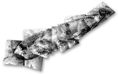
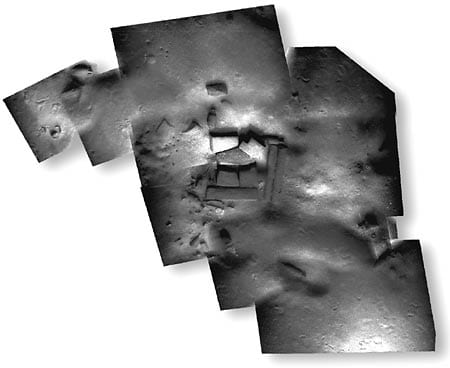
In June, the DSL team traveled to the Mediterranean on an expedition led by Bob Ballard, WHOI Scientist Emeritus and currently President of the Institute for Exploration in Mystic, Connecticut. They surveyed and photographed a cluster of eight ships lying 2,500 feet beneath an ancient trade route and ranging in age from about 100 B.C. to the 19th century. The image at right was created from data taken on this expedition, which will be featured on National Geographic Television’s Explorer series in early 1998 and in a spring 1998 National Geographic magazine article.
In September, the DSL team loaded their equipment on Atlantis, joining a project led by John Delaney of the University of Washington and Edward Mathez of the American Museum of Natural History. This marked the beginning of fieldwork for a collaboration between the two institutions whose goal is to recover a suite of large black smokers from the hydrothermal vent area on the Juan de Fuca Ridge off the Oregon coast for both scientific analysis and museum display. It also marked the first voyage that combined both occupied (Alvin) and remote vehicle operations from Atlantis. Multi-scale mapping with the towed DSL-120 Sonar vehicle preceded Jason photography with the objective of precise imaging of a suite of smokers for recovery in 1998.
“What a year!” Yoerger comments. “We worked sites from a kilometer square at Derbyshire to centimeters at the Med sites and from flat, muddy seafloor to a real 3-D environment with overhangs and generally rough topography at Juan de Fuca. We’ve served widely varied user communities and have new data and engineering problems to tackle as a result of these expeditions.”
Slideshow
Slideshow
- This photomosaic was created from sonar and photo data taken during Bob Ballard?s Mediterranean expedition in summer 1997. It shows the cargo of a 1st century A.D. vessel that carried heavy building stones packed in at least two layers in a roughly square central section of the hold
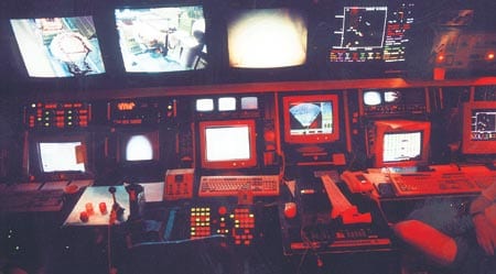
- This photo was taken in the Jason control van during the Mediterranean expedition.
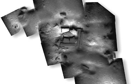
- This image was constructed by Deep Submergence Laboratory Research Engineer Jonathan Howland during development of the photo mosaicking technology. It shows a 19th century Mediterranean wreck site surveyed and imaged in 1995 by the Navy?s NR-1 submarine during reconnaissance for the 1997 expedition
Related Articles
- Five marine animals that call shipwrecks home
- Can environmental DNA help us find lost US service members?
- Re-envisioning Underwater Imaging
- Ancient Skeleton Discovered
- Inside the Sunken USS Arizona
- Why Did the El Faro Sink?
- A Luxury-Laden Shipwreck from 65 B.C.
- Farewell to the Knorr
- The Exosuit Comes Aboard
