The New Wave of Coastal Ocean Observing
Shore stations and seafloor nodes provide connections for long-term studies of coastal processes
Most traditional means of observing the ocean have their limits. Research ships and submarines must return to port. Robots and moored instruments run out of battery power. Satellites have stamina but their view does not penetrate into the depths. Ships and subs can carry only a few scientists at a time, and never into dangerous but scientifically interesting conditions such as hurricanes. Consequently, scientists have had to be satisfied with intermittent glimpses of the environment.
The next wave of ocean science will be done full time, and in real time. In recent years, ocean scientists and engineers have been developing new ways to go to sea—and stay out there—without getting seasick. They have been plugging instruments into seafloor nodes connected directly to shore-based labs, and using electro-optic-power cables to transmit steady streams of power and data.
At locations such as the Martha’s Vineyard Coastal Observatory (MVCO) operated by Woods Hole Oceanographic Institution, researchers have staked out a parcel of ocean and are observing it with 24/7 vigilance, with the potential to do so for years. They can continuously measure what is happening on the sandy ocean bottom, in the water column from the seafloor to the surface, and in the air above it. And they can do it while sitting at their desks. Thanks to the cables, data from the sea are freely available on the Internet in real time to an unlimited number of scientists.
Unconstrained by time, space, and foul weather, scientists are starting to use coastal observatories to move past the snapshots of ocean processes, the restricting “befores” and “afters” that do not allow them to learn what happened in between. Now they can illuminate processes. How do storms rearrange shorelines and seafloor sediments? What is exchanged at the interface between air and water, and how does it affect coastal weather? Why do currents change seasonally? How do environmental changes affect plankton at the base of the marine food chain?
New window on the Atlantic
Built in stages since 2000 on the south shore of Martha’s Vineyard, MVCO provides a natural laboratory to study key coastal processes in the North Atlantic. Permanent and project-specific instruments have measured the motion and strength of currents, the movement of sediments, the cycles of microscopic plants and animals and the bottom-dwelling creatures that eat them, the exchange of gases and aerosols between the ocean and atmosphere, and coastal meteorology.
Just 90 minutes from Woods Hole on WHOI’s coastal research vessel Tioga, MVCO is exposed to the open ocean and a wide range of conditions, including energetic tides and surface waves, and winds ranging from dead calm in summer to intense storms in fall and winter. In a seasonal rhythm, offshore waters become stratified in summer, with warmer surface waters atop denser, colder waters; in winter, the water column becomes homogeneous again.
The National Science Foundation (NSF) and Woods Hole Oceanographic Institution shared the costs to build a small, inland shore lab, a 10-meter mast with meteorological instruments at the ocean’s edge, and a seafloor node 12 meters below the sea surface and 1.5 kilometers from the shore. Cables connect the sensors at the mast and sea node to computers and communications devices in the shore lab.
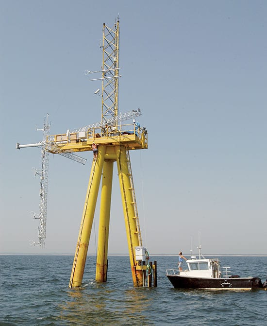
In 2002, the Office of Naval Research (ONR) provided support for the design, construction, and deployment of an Air-Sea Interaction Tower (ASIT) about 3 kilometers from Martha’s Vineyard. The tower stands in 15 meters of water and extends 22 meters above the water line into the atmosphere. It is connected through its own fiber-optic cable to the shore lab.
The node and tower act as scaffolding and “extension cords,” allowing scientists to install instruments in the coastal environment, then return home to collect data over the Internet. If equipment fails, they can quickly detect the problem and go fix it.
Wind, rain, or dark of night
In addition to long-term, continuous, and easily accessible streams of data, coastal observatories provide other advantages. Structures such as MVCO can allow scientists to chronicle the processes at work during extreme events that were previously difficult to study.
For instance, scientists have spent decades making shipboard expeditions to measure how the air and sea exchange heat, water, gases, and momentum. But they have learned little about what happens when wind speeds exceed 40 to 50 knots because no ship captain will intentionally cruise into a hurricane and risk lives to make such measurements. Even in less extreme circumstances, the natural movement of a research vessel leaves scientists wondering how much of what they measure is real and how much of it is “ship noise.”
Coastal observatories also can help engineers who are developing and testing new instruments. For instance, researchers working on power-hungry, advanced sensors have plugged into MVCO to test the effectiveness of their instruments without the power limits of batteries or the time limits of ship-based expeditions.
Getting down to business
Today, WHOI scientists and engineers are working with colleagues from around the country, using MVCO for a variety of interdisciplinary and multi-institutional research projects. These have included:
- The Coupled Boundary Layers and Air-Sea Transfer (CBLAST) program, supported by ONR. This experiment, conducted in the summer of 2003, focused on the dynamic interaction between winds, waves, and ocean-mixing processes as they exchange heat, water, energy, and gases (such as carbon dioxide) between the ocean and atmosphere. These exchanges are fundamental processes that determine coastal weather and play a critical but oft-unappreciated role in global climate.
- Surface Processes and Acoustic Communications (SPACE), and Optics, Acoustics, and Stress In Situ (OASIS), supported by ONR. Investigators are evaluating how bubbles near the sea surface and suspended sediments in the water column affect the propagation of sound and light underwater. Bubbles, turbulence, and sediments accumulate and behave differently in shallow water—where the Navy is primarily working today—than in deep water—the region of most naval interest during the Cold War. The Navy relies on the accurate transmission and reception of sound and light signals for underwater communication and remote sensing.
- Plankton dynamics experiments, supported by NSF and the National Aeronautics and Space Administration. Long-term studies of plankton dynamics—to learn how, when, where, and why microscopic marine plants and animals flourish—take advantage of two newly developed instruments: the FlowCytobot and the Autonomous Vertically Profiling Plankton Observatory (AVPPO). FlowCytobot is a laser-based system to monitor and identify microscopic plankton down to individual cells. The AVPPO repeatedly records images of plankton scattered throughout the water column. Long-term deployment of such power-hungry instruments is only possible with the type of infrastructure at MVCO.
- Sediment transport experiments, supported by ONR. Researchers have been investigating the processes and factors—including winds, waves, currents, tides, and seafloor topography—that move sand and shape the seafloor around MVCO. In a related project, researchers have investigated the processes that bury objects such as military mines in seafloor sediments.
undefined - Ozone chemistry experiments, supported by NSF. Researchers have deployed instruments on the ASIT to quantify how much ozone pollution is being removed from the atmosphere and deposited into the ocean.
- Ocean Horizontal Array Turbulence Study (OHATS), supported by NSF. An air-sea interaction experiment is using 18 closely spaced sonic anemometers, or wind gauges, to examine the effect of ocean waves on air turbulence and eddies. The observations, begun in August 2004, should allow researchers to improve weather prediction models.
Building for today and tomorrow
With initial experiments underway and some lessons already learned at MVCO, WHOI scientists and engineers are making plans to improve and expand the facility.
Autonomous underwater vehicles (AUVs) and other robotic vehicles will likely play an important role in future studies at MVCO and other ocean observatories. Researchers can use observatories as remote ports from which they can launch these vehicles into inaccessible regions and extreme conditions. Equipment is already being tested to allow AUVs to download data and recharge their batteries at underwater nodes.
WHOI researchers are also working with colleagues at other institutions to create a network of coastal observing systems extending from the Gulf of Maine to Florida. By linking observations of several observatories along the East Coast, researchers will be able to develop a clearer picture of the long-term cycles and processes at work in the northwestern Atlantic. From hurricanes to migrating marine life to eddies spinning off from the Gulf Stream, coastal observers will be able to track developments in the ocean from start to finish and season to season. The result will be a more precise view of everyday life in one of the world’s oceans.
Slideshow
Slideshow
 STANDING TALL—The Air-Sea Interaction Tower, built as part of an experiment sponsored by the Office of Naval Research, allows scientists to deploy instruments that monitor the relationship between winds and waves in all weather conditions. (Photo by Jayne Doucette, Woods Hole Oceanographic Institution)
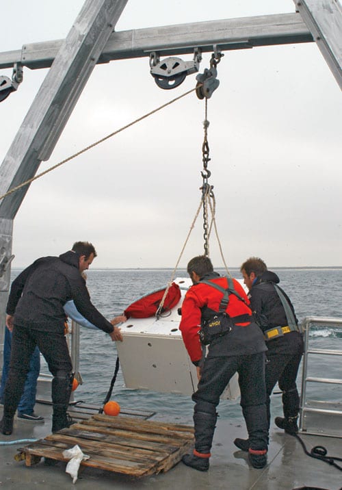 UNDERWATER POWER STRIP—The seafloor node of the Martha’s Vineyard Coastal Observatory, shown here being lowered into the water, supports experiments but it is also an experimental technology itself. Scientists plug into the node’s power supply and data cables to study everything from shifting sands to blooming plankton. (Jayne Doucette, WHOI Graphic Services. )
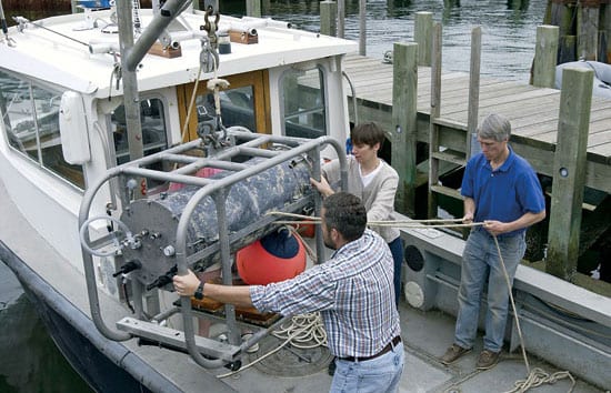
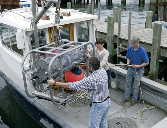 New robotic technologies and cutting-edge instruments—such as the plankton-observing FlowCytobot—are tested at MVCO before heading off to projects in other regions. (Tom Kleindinst, WHOI Graphic Services.)
Related Articles
- The little big picture
- Navigating new waters
- On the Move
- From Northern California to Ocean Engineer
- In the Ocean Twilight Zone, Life Remains a Mystery
- New glider design aims to expand access to ocean science
- Gift enables new investments in ocean technologies
- Can seismic data mules protect us from the next big one?
- Life at the Edge
See Also
- Martha's Vineyard Coastal Observatory
- A Geospatial Framework for the Coastal Zone: National Needs for Coastal Mapping and Charting
- Enabling Ocean Research in the 21st Century: Implementation of a Network of Ocean Observatories
- Oceanus: A New Coastal Observatory is Born Published Jan. 2000
- Oceanus: A Well Sample Ocean
- Oceanus: Seeding the Seafloor with Observatories
- Coastal Ocean Observatory Lab (COOL) Classroom
