A Pioneering Vision
In 2005, scientists at Woods Hole Oceanographic Institution devised a revolutionary plan: They would deploy about 150 scientific instruments in coastal waters south of Martha’s Vineyard to try to understand what makes that region of the ocean teem with life—from tiny marine plants to fish, seabirds, and whales.
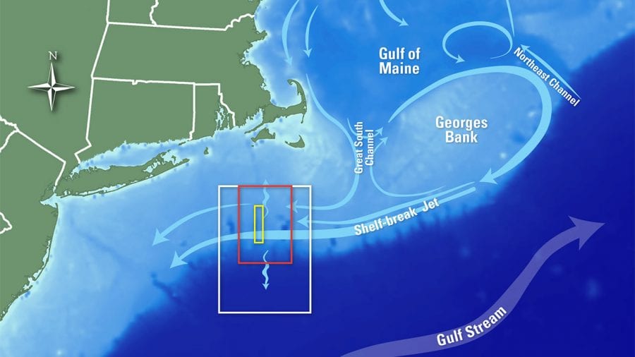
 A team of WHOI scientists and engineers developed a multidisciplinary ocean observing system that now spans about 160 square miles centered on the undersea edge of New England’s continental shelf, where it “breaks” and begins to slope downward toward the deep ocean. At the shelf break, ever-shifting currents create an underwater frontal system—the watery equivalent of the meteorological fronts that weather forecasters talk about—and a zone of continually changing seawater temperature, salinity, nutrients, and other factors that influence marine life.
The Pioneer Array, as WHOI’s coastal observatory is named, was conceived in response to a 2005 call for research proposals from the National Science Foundation (NSF). The array includes a network of ten moorings anchored to the seafloor, along with a fleet of underwater vehicles weaving between and beyond them. Sensors on the moorings and vehicles measure meteorology, water density, chemistry, light, nutrients, and currents, from above the water’s surface down to the ocean floor. And they operate around the clock, every day, all year long.
Pioneer is one part of an even more ambitious, multi-institutional Ocean Observatories Initiative (OOI). Funded by the NSF with an initial investment of $386 million, the OOI aspires to transform ocean research. In a radical departure from oceanography-as-usual, the initiative established an enduring scientific presence in the ocean, envisioned to last a quarter-century.
Like other OOI infrastructure, the Pioneer Array provides a continuous, ever-growing trove of diverse ocean measurements that are transmitted via satellite in near-real time and made freely available—not just to the small group of American scientists and engineers directly involved with the project, but to anyone with an internet connection, anywhere.
In contrast with the other OOI arrays, which are intended to remain in their original locations for 25 years, Pioneer—as its name suggests—is designed to be relocated to explore different ocean environments. The Pioneer Array envisioned by the 2005 WHOI team—physical oceanographers Glen Gawarkiewicz, Breck Owens, and Al Plueddemann, along with biologist Heidi Sosik—can shine a scientific spotlight on any complex coastal region and reveal the hidden phenomena within its waters. It was designed to be moved every five years or so to a new coastal frontier, blazing a new trail to scientific discovery.
But its first mission is on the New England shelf break, about 90 miles offshore.
Science on the edge
So how do you study a complicated, ever-changing ocean environment? In a situation like that, said Paul Matthias, the traditional approach to oceanography may not be enough.
“The majority of past observations have been ship-based expeditions of limited duration,” said Matthias, a WHOI senior project engineer who manages the OOI components deployed and maintained by WHOI, including the Pioneer Array. A typical research cruise lasts only two or three weeks, limiting the amount of data that can be collected. The observations are “not continuous, they’re not year-round, they’re not under extreme weather conditions,” Matthias said. “Inevitably, scientists miss important oceanic processes that happen when they’re back on shore.”
Another option would be to rely on data from Earth-orbiting satellites, which are on all the time, making close-to-continuous observations of the ocean. But while satellite-based sensors provide useful information about the sea surface and, to some extent, the seafloor, “they can’t tell you anything about what’s happening at depths in between,” Matthias said, “and they can’t provide the resolution afforded by the array.”
“If you really want to know what’s going on, you have to have some way to get down there and make measurements under water,” said John Trowbridge, who is a co-chief scientist for the OOI’s Pioneer and Global Arrays. “You can do that with either moorings or vehicles.”
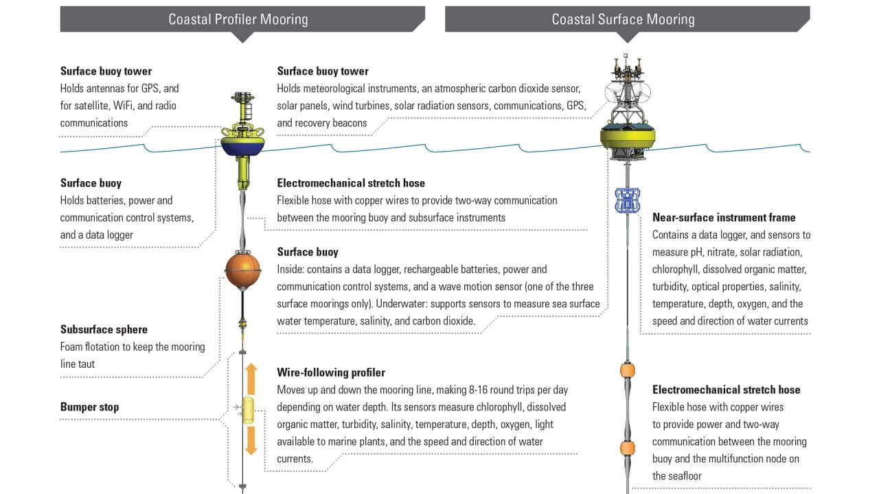
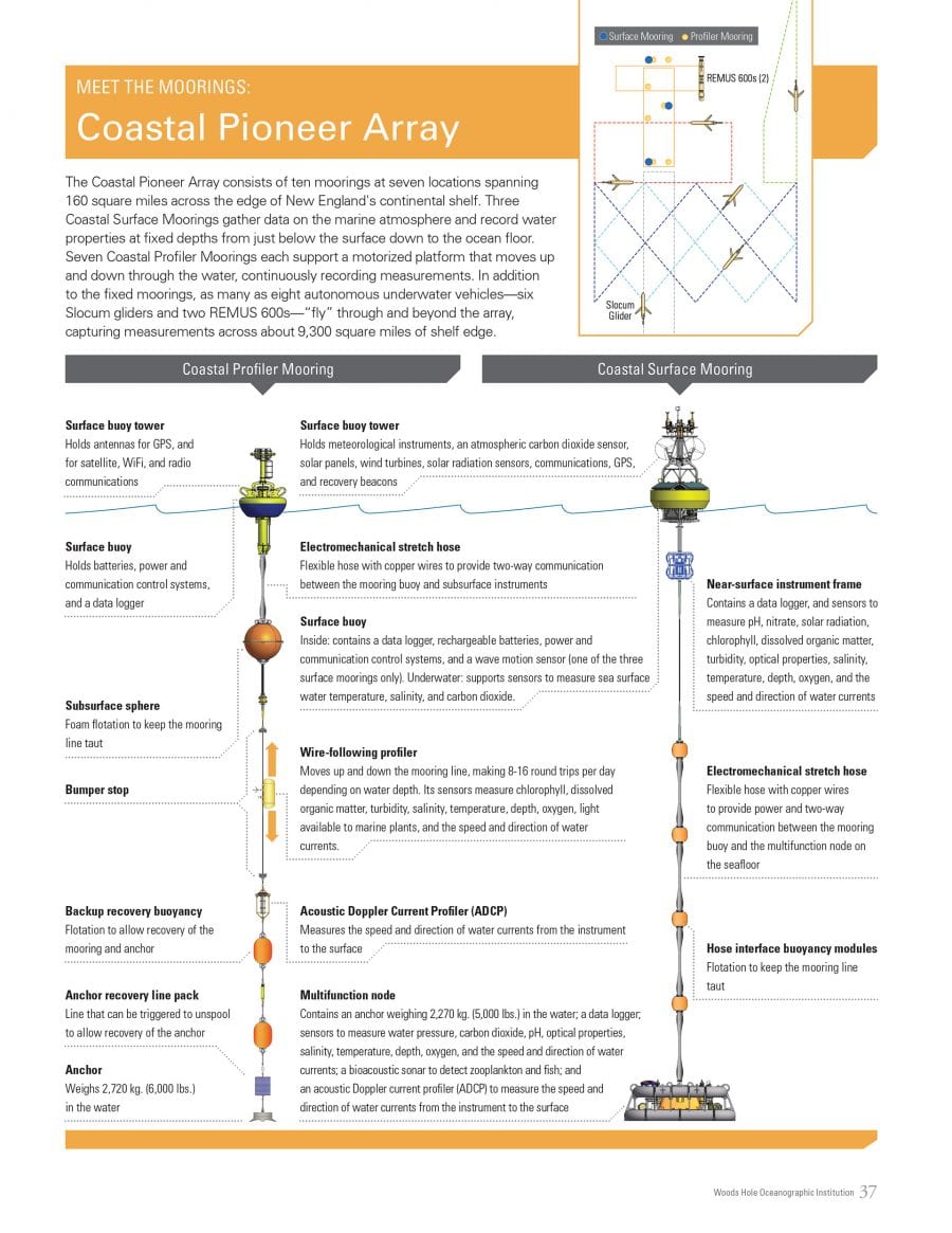
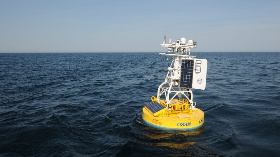
At its most basic level, a mooring is an anchor on the seafloor, attached to a line, chain, cable, or some combination that is held taut by a flotation buoy on or near the surface. Scientific instruments attached to a mooring line and buoy can do what expeditionary research and satellites can’t: take measurements from above the ocean surface down to the bottom, 24 hours a day, 365 days a year. But to study rapidly changing conditions over a large area such as the continental shelf break, a single mooring is not enough.
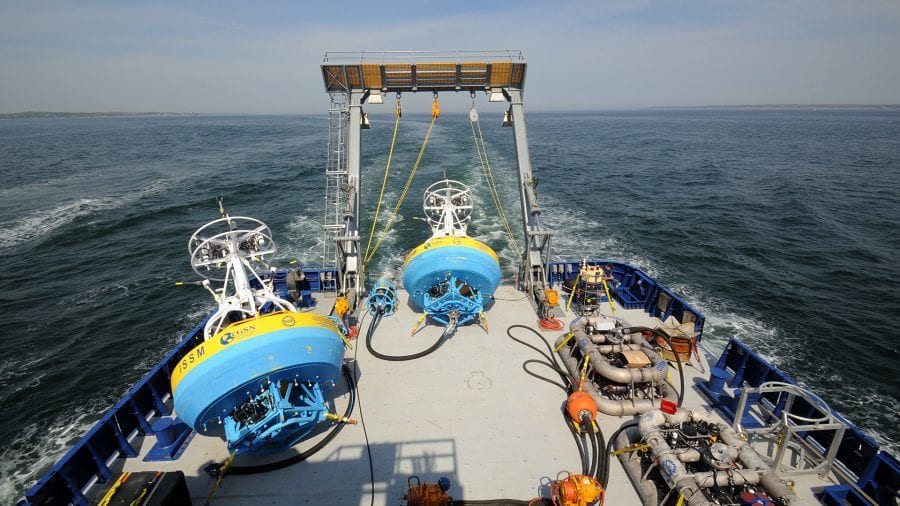
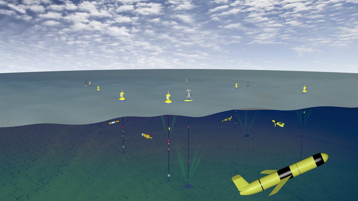
The Pioneer Array has ten anchored moorings at seven locations spanning the edge of the continental shelf, where water depths range from about 300 to 1,500 feet. Sensors on buoys floating on the sea surface gather meteorological information about the atmosphere above the ocean. Under water, instruments attached to mooring lines and anchor frames measure current speed and direction, temperature, salinity, oxygen, organic matter, and other seawater properties that scientists can use to piece together a dynamic, multifaceted profile of what’s happening in the ocean.
Many of the instruments on Pioneer Array moorings are powered in a conventional manner, with single-use batteries like those found in a flashlight. For moorings with surface buoys, however, WHOI engineers developed an innovative power scheme that uses wind turbines and solar panels to provide power to rechargeable batteries inside the buoy. A distribution system made up of custom mooring line components sends power and communications from the buoy at the surface all the way down to the anchor frame on the seafloor.
Pioneer’s moorings stay at sea for six months at a time. But scientists on shore don’t have to wait half a year to see Pioneer’s data: Many of the measurements are transferred back to shore via satellite almost as soon as they’re collected.
“We’re trying to provide more power than is typically available on moorings. We’re also trying to provide higher-bandwidth communications,” said Sheri White, the lead systems engineer for WHOI’s OOI arrays. “We’re trying to push the envelope and do more than what people typically do.”
Moving beyond the moorings
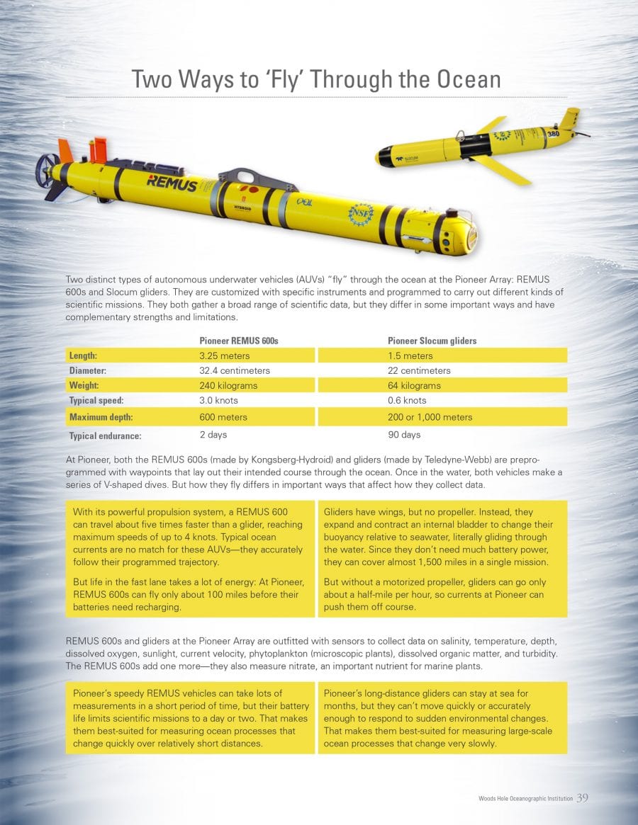
The moorings make frequent measurements and collect a lot of data, but only in seven places spread over 160 square miles. To cover more territory, as many as six remotely controlled ocean gliders and two REMUS 600 autonomous underwater vehicles, or AUVs, “fly” between—and well beyond—the moorings, capturing measurements across about 9,300 square miles of shelf edge in all.
The bright yellow, torpedo-shaped ocean gliders move slowly through the water, traveling just over half a mile per hour. “Glider speeds in the water are about the same as a fast tortoise on land,” WHOI physical oceanographer Al Plueddemann said. “Observing the full Pioneer region with six gliders is like using six tortoises to patrol an area the size of New Hampshire.”
The gliders are slow because they have no propeller; they glide through the water by changing their buoyancy. Strong currents can push them off course—but being slow also has its benefits. Gliders require little energy and can stay at sea for months at a time, efficiently measuring temperature, salinity, and other ocean properties across vast areas, collecting data from near the surface down to nearly 3,300 feet. The vehicles surface periodically and “phone home” via the Iridium satellite network, allowing WHOI pilots back on shore to monitor them remotely and reprogram them to keep them on course or to investigate oceanographic features of interest.
The larger REMUS 600 AUVs are equipped with a propeller-driven propulsion system, so they can zip through the water at least five times as quickly as the gliders, capturing high-resolution measurements of current velocity, dissolved oxygen, nitrate concentration, and other water characteristics. These more powerful vehicles can be programmed to closely follow a specific course through the array, but their need for battery power limits their time in the water to about two days. During a mission, scientists onboard a ship can communicate with a REMUS AUV—via acoustic modem when it is submerged, or via satellite when it comes to the surface at preprogrammed locations—to monitor a vehicle’s status and make any needed adjustments.
“Together, the moorings, gliders, and AUVs form an unparalleled array of complementary platforms that make continuous ocean observations across a broad swath of coastal ocean,” Plueddemann said. “There is no single alternative method I can think of that would create the complete picture.” The dynamics of the shelf break are just too complicated. “To get at the combined physical, biological, and chemical properties, as well as the spatial and temporal variability, you need a lot of tools in the water at the same time.”
Non-routine maintenance at sea
Keeping so many scientific moorings, vehicles, and instruments functioning in the ocean for months at a time isn’t easy.
“The ocean is an unfriendly place,” Matthias said. “And one of the last things one would choose to put in the ocean is something electrical.” In salty, constantly moving seawater, it’s easy for equipment to corrode, wear out, or break. Anything electrical or fragile has to be wrapped in protective materials, covered in a resistant coating, or carefully sealed in watertight enclosures. To help the moorings endure the extreme tension created by powerful winds, waves, and currents, Pioneer’s designers took advantage of an earlier technological innovation developed at WHOI: strong but highly stretchable hoses that contain electrical wires that are engineered to withstand the punishing push and pull of turbulent coastal waters.
John Kemp has experienced the ocean’s unfriendliest forces firsthand. Kemp has been deploying scientific moorings for four decades, and he is one of the few people at WHOI to have worked on the OOI since its inception, designing moorings and leading operations at sea. He says the Pioneer Array was built to last.
“We do a lot of dynamic modeling with all the components,” Kemp said—simulating harsh environmental conditions to see whether the array components will survive. “The system is designed to withstand what we call a hundred-year storm, where you typically have winds about sixty-five miles an hour and wave heights of fourteen to eighteen meters.”
Even so, strong currents can set a mooring cable strumming like a giant, out-of-control guitar string. “It can vibrate components off the board,” Kemp said.
And then there’s marine life to contend with, he said. “Sharks and other fish will be excited by the strum of the cable and bite it.”
There are also more mundane kinds of biofouling—a term used to describe what happens to scientific equipment when algae, barnacles, and other marine life decide to call it home. “All kinds of different creatures colonize the platforms we put out in the water,” Plueddemann said. Too much biofouling can make sensors malfunction, so instruments need to be removed and cleaned on a regular basis.
Recreational and commercial activities at the crowded edge of the continental shelf present their own share of challenges. Despite notices to mariners and coordination with the U.S. Coast Guard, there is the possibility that boats will run into the Pioneer’s moorings—or choose to tie up to them. Commercial shipping-lane traffic can pose a hazard to surfacing gliders. And fishing gear can inadvertently become entangled in mooring lines, damaging sensors and other equipment.
“To be able to deploy a mooring out there for a defined interval is one thing,” Matthias said. “To be able to deploy ten moorings out there, again and again, year after year, so that there’s a continuous stream of data, is a significant leap forward in robustness and resilience and engineering design.”
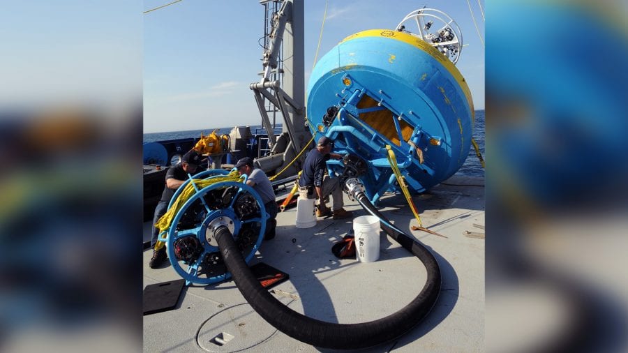
To keep the Pioneer Array going, WHOI maintains two complete sets of each mooring, vehicle, and sensor. The array has to be “turned” every six months: WHOI engineers, scientists, and crews travel by ship, pull all the array’s components out of the water, and deploy clean, repaired, and fully charged replacements.
The human element
Turning an array is tricky work.
Safely wrangling tons of equipment in and out of the ocean from the deck of a ship takes skill, experience, and seamless coordination between scientists and crew. “Things have to happen really quickly,” Matthias said. “You’re talking about a very high level of safety awareness and capability of both groups.”
There’s a lot at stake. The equipment is expensive, loaded with delicate sensors, and heavy: A single, fully equipped surface mooring costs about $1.5 million; its surface buoy alone weighs about 10,000 pounds; its loaded anchor frame, another 10,000.
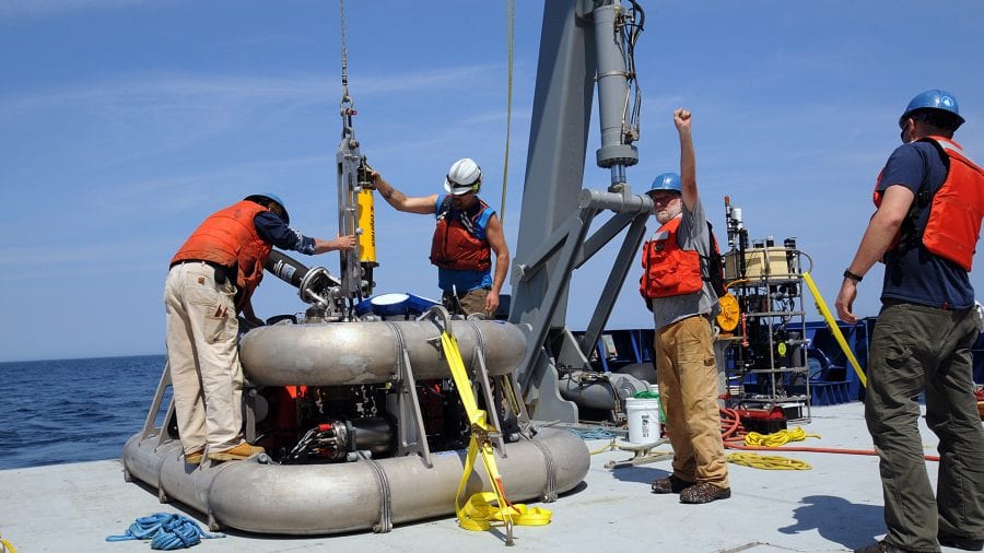
Deploying and recovering moorings is by necessity a team effort. Plueddemann, who has been chief scientist on eight cruises to the Pioneer Array, said it can take more than half a dozen people to maneuver a surface buoy into the water, each person controlling a different line or rope.
“You’ve got seven people running seven different lines—four tag lines, a pickup line, a quick-release line, a stopper line—and that all has to be coordinated. Everybody has to know what to do, and do it at the same time,” Plueddemann said. “When it works well, it looks really easy.”
But it doesn’t take much for things to go wrong.
“If somebody’s line is too tight, or somebody’s line is too loose, or they don’t get it cleared away from the buoy after it’s in the water, all of a sudden you’re in some sort of trouble,” Plueddemann said.
As the leader of deck operations, Kemp has the job of making sure trouble doesn’t happen. “I’m ultimately responsible for everybody out there. I don’t want to see anybody get hurt,” he said. “Most of it is experience, from doing it so many times, thousands of times, that it kind of becomes second nature to you.” And with 40 years of mooring experience under his belt, he pretty much has it down.
Just to make sure, though, he still plans out every move he and his team will need to make.
“In the morning, or the night before, I go through it in my mind,” Kemp said. “I step it out, how things should be done, make sure I know what I’m going to do next.”
At work on deck, Kemp seems to be everywhere at once, switching from choreographer to quarterback to coach. “It’s no secret: Kemp doesn’t sit still for more than a minute,” he joked about himself on a recent cruise. Under his watchful eye, crew members, engineers, and scientists quickly transition from station to station, cranking winches, adjusting lines, and maneuvering the ship’s towering A-frame, which hoists and lowers the mammoth buoys.
During a fast-moving deployment, communication can seem nearly telepathic.
“People are in the right place before you realized you needed them to be there,” Matthias said of Kemp and his colleagues. “They’re working on a tag line, or are up in the crane cockpit. Or the ship is coming around and pointing itself upwind. All of these things happen almost without words being spoken, exactly when they need to.”
To an inexperienced observer, the process looks a little magical—and more than a little dangerous.
“There are risks to everything,” Kemp admits. “But if you are well-planned, follow established procedures, and have good equipment, the risk is low.”
Sharing the data trove
The first test deployment of the Pioneer Array took place in 2011. That was followed by mooring redesigns and more deployments until, in 2016, the NSF declared the array fully operational.
Trowbridge said the word he heard most often in the early days of the project was “transformative.” Pioneer—and the rest of OOI—represented a radical shift in how ocean science operates.
“Usually in oceanography, individual principal investigators write proposals,” Trowbridge said. If things go well, a proposal gets funded. “The PI goes out, does the measurements, does whatever analysis, keeps the data sitting around on a hard drive somewhere, and you have to ask permission to see it.” The lead scientist might publish a paper, but not the raw measurements.
The OOI turns that paradigm on its head, putting all its data online, free for anyone to use.
“I think it’s good for the community,” Trowbridge said, calling the old model “limiting.” In other fields with more access to data, he said, scientists can do their own analyses and come up with their own results. “I think oceanography’s going to advance when we’re able to do that too.”
Data from the Pioneer Array is already yielding new discoveries. Current plans are for it to stay on the shelf break until 2021, then move on—maybe to the Gulf of Mexico, or off the southeastern coast of the United States—to explore another oceanographic frontier.
Slideshow