Knorr Shoots the Moon (Pool) to Drill for Coral
Coral cores offer an unprecedented record of the rise and fall of Earth's sea level
There is a hole in the hull of the research vessel Knorr, and Capt. Kent Sheasley couldn’t be happier about it.
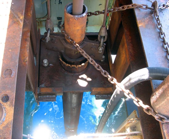
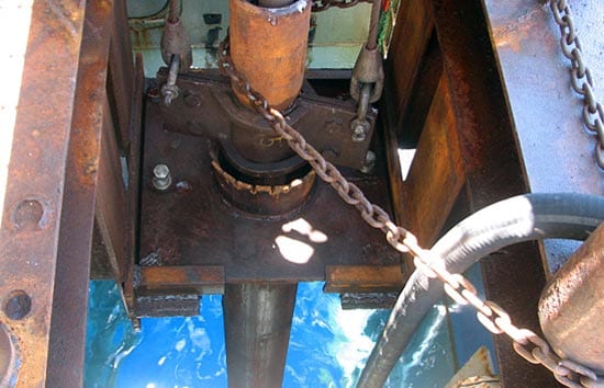
The Knorr’s so-called “moon pool” is a section of the hull that can be removed to give scientists direct access from the deck to the sea. In research ships, it is like a recessive gene: Few ships have moon pools, and those that do, rarely use them, so people forget they are even there.
“We’ve used it mostly to store sodas,” Sheasley said.
But in May 2007, Knorr’s crew opened its long-dormant moon pool and took out the Cokes and Sprites to enable a small team of scientists and commercial drillers to temporarily transform Knorr into a drilling vessel. During a five-week expedition off the coast of Barbados, the team drilled and recovered a treasure trove of slender cores from ancient, fossilized coral reefs. The coral cores will provide an unprecedented, detailed record of the rise and fall of Earth’s sea level over the past 40,000 years—deep into Earth’s last ice age, which ended roughly 10,000 years ago.
The team also discovered a coral reef that was alive during the last ice age, which encircles Barbados like a coral necklace. Using Knorr’s multibeam sonar, they created detailed, three-dimensional maps of the reef, which lies 410 feet (125 meters) under water, said Richard Fairbanks of the Lamont-Doherty Earth Observatory, who was the expedition’s chief scientist.
Drilling in shallow water
Much like tree rings, coral skeletons grow outward in bands that can be precisely dated. Drilling through the bands (and back in time), the researchers recovered 60 meters of cores from massive stony “Elk Horn” coral (Acropora palmata). Because they live only in waters no deeper than 16 feet (5 meters), they are a reliable “dipstick” to measure where sea level was, and when.
But that same characteristic also makes corals hard to sample. They lie a little too deep to be cored efficiently by divers or anchored platforms, and a little too shallow to bring in the 470-foot-long (143-meter) JOIDES Resolution, the international research community’s large riserless drill ship, which is more suited for deeper, much more complicated operations.
The JOIDES Resolution comes replete with a 202-foot-high (62-meter) derrick and “expert drillers and science techs who are all extraordinarily professional and know what they’re doing all the time,” said Kathy Ellins, program manager of the University of Texas Institute for Geophysics, who used to work with the international drilling program that operates the JOIDES Resolution and who also participated in the Barbados expedition. “In this sort of shallow-water operation, you’re basically doing it yourself. You bring your own drill crew, your own drilling equipment, and you have to be much more involved in overseeing the operation itself.”
The team included a five-man drill crew from the Warren George Drilling Company in New Jersey, which was more accustomed to drilling on land, Sheasley said. “This project was pretty new to them,” he said, but he described their work as exceptional.
Recording sea level’s ups and downs
For Sheasley, “this [expedition] stands out as one of the highlights of my last 12 years with the Knorr.” It was his first experience as captain during a drilling operation.
“Any time you have something on the bottom of the ocean that is rigidly connected to the ship [like a drill rig] and is moving, you are concerned,” he said. “It’s not like this was a little sensor package.” The so-called “mini drill rig”—a two-ton tilly owned by Fairbanks—took just one day for the team to set up. “The moon pool is a much better place to deploy a drill system,” much safer than having to go over the side, Sheasley explained.
While various drill bits were lost to Davy Jones’ locker through the moon pool throughout the expedition, the operations went just as smoothly as possible—thanks to the chemistry and diligence of the small team, a healthy dose of good weather, and the Knorr’s capabilities, Sheasley said.
In addition to the moon pool, Knorr’s dynamic positioning system (“DP” in ship-speak) earned a standing ovation for its ability to keep the ship “steady as she goes” during drilling operations. The DP powers the ship’s propellers and thrusters to maintain its geographic position on an ever-moving ocean. Heave—the up and down, pogo-stick motion of the ship—was the biggest challenge on this particular cruise.
“The ship was as stationary as you can ask for a ship floating on the ocean,” Sheasley said. “It moved less than a meter for 95 percent of the cruise.”
“I was actually kind of excited to get a chance to spread our wings with this new DP system,” which was installed in 2003, said Sheasley. “We’ve used it a lot, but it takes something like this to highlight its precision.”
The price is right
Another bonus was the cost of the mission. Whereas Knorr costs roughly $20,000 per day, the JOIDES Resolution costs more than three times as much. “Reading the record of our planet’s deep time, like the costs associated with looking into deep space with the Hubble telescope, comes at a price,” said Jeff Fox, director of the Integrated Ocean Drilling Program (IODP), which manages the JOIDES Resolution. Larger dynamically positioned ships like the JOIDES Resolution cannot drill in water depths shallower than 164 feet (50 meters), Fox said. Knorr drilled in depths ranging from 105 to 295 feet (32 to 90 meters).
“The Knorr provides an important new capability in allowing scientists to harvest our planet’s record in shallower-water environments and at relatively shallow depths below the seafloor,” Fox said.
Ellins agreed, saying the recent Knorr expedition could serve as a model for drilling operations in shallow water—a long-acknowledged technological challenge. She projected that perhaps Knorr could be used as a complementary operation to a larger-scale operation on the JOIDES Resolution.
Snapshots of climate history
The team recovered a total of 60 meters of ancient coral cores (placed together end to end, they’d look like a tube that is nearly the height of a 20-story building). Barbados is the only location where scientists have recovered “ice age” corals, said Richard Mortlock, a researcher at Lamont-Doherty, where the samples will be dated and analyzed.
“Each piece provides a snapshot of climate history,” said Mortlock, who participated in the expedition. “That’s why it is important to drill multiple holes at one site in order to piece together hundreds of snapshots into a more complete story.”
The cores were also just about as good as you could ask for, Ellins said. “It was spectacular because we pulled up the coral all nicely intact. Usually you get all these gaps,” which leave chronological holes in the sea-level record.
The cores also contained layers of beach rock, which can only form at sea level, Ellins said. The beach rock was further confirmation that the ancient corals were once in very shallow water near the coastline. Ellins and researchers in the Jackson School of Geosciences at The University of Texas will analyze these samples back in the lab.
“Beach rock is particularly fragile when coring, but the mini-drill successfully cut through and preserved the delicate fabric of this rock type,” said drill crew foreman Gustavo Suri.
Back to the future
In addition to revealing sea level, the corals will tell scientists something about the ocean water conditions during the time they grew—such as temperature and salinity—and even something about the radiocarbon content of the atmosphere, Mortlock said.
The cores will also help scientists infer how many ice sheets and glaciers were around at particular times in Earth’s past: When sea level was low, scientists assume that more of Earth’s water was frozen in ice sheets, and the climate was colder. By providing clues to how ice sheets collapsed in the past, the cores will help scientists predict the causes and effects of future ice sheets collapses in a warming world, Fairbanks said.
The cruise’s other major success was the discovery of an ice-age reef encircling Barbados. But don’t go looking for it the next time you take a Barbados getaway; this reef lies in 410 feet (125 meters) of water, so you can’t see it. The science team found it thanks to Knorr’s multibeam system, which uses sound waves to take images of the seafloor.
The multibeam system defied expectations because it is known to work best in much deeper water, Ellins said. “The techs didn’t think we’d be able to see anything but in fact, we did. The reef is beautifully defined, going all around the island so you can see exactly where the reef was in the last glacial maximum.”
The finding gives scientists another target in the future to drill for ancient coral samples, she said.
Ellins said the expedition “was such a great example of so many things coming together really well: the ship, the equipment, bringing the drill crew out from land, getting this record. …”
“People mingled, got along, and the whole atmosphere was just a lot more productive, friendly and relaxed,” Sheasley said.
The National Science Foundation funded the research.
Slideshow
Slideshow
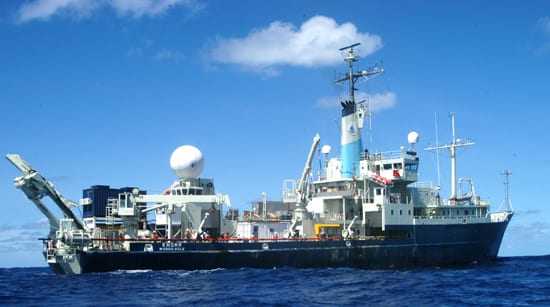
 To obtain cores of coral, crew members on the WHOI-operated research vessel Knorr opened its long-dormant moon pool?a removeable section of the hull?to enable a team of scientists and commercial drillers to temporarily transform the ship into a drilling vessel. (Photo by Alexander Dorsk, Woods Hole Oceanographic Institution)
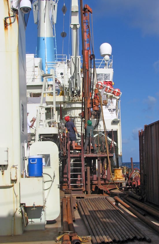
- Researchers obtained their cores by running the drill through the ship's moon pool. During a five-week expedition off the coast of Barbados, the team drilled and recovered cores from ancient, fossilized coral reefs. The coral cores will provide a record of the rise and fall of Earth?s sea level over the past 40,000 years?deep into Earth?s last ice age, which ended roughly 10,000 years ago. (Photo by Kathy Ellins, Institute for Geophysics, Jackson School of Geosciences, University of Texas at Austin)
- A team from the Warren Davis Drilling Company in New Jersey brought along and assembled their own drill rig to obtain needed coral cores. Kathy Ellins from he University of Texas called Knorr "an extraordinary platform for shallow-water drilling work," adding that the ship's stability was essential to do the work. (Photo by Kathy Ellins, Institute for Geophysics, Jackson School of Geosciences, University of Texas at Austin)
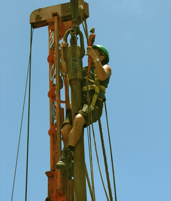
- A member of the drilling team ascends the drill rig to connect a hose used to flush the drill pipe. By the end of the cruise, the team recovered a total of 60 meters of ancient coral cores (placed together end to end, they?d look like a tube that is nearly the height of a 20-story building). (Photo by Kathy Ellins, Institute for Geophysics, Jackson School of Geosciences, University of Texas at Austin)
Related Articles
Featured Researchers
See Also
- R/V Knorr
- New Coral Dating Technique Helps Resolve Changes in Sea Level Rise in the Past WHOI News Release
- Institute for Geophysics, The University of Texas at Austin
- Coral and Sea Level Research from Lamont-Doherty Earth Observatory
- Integrated Ocean Drilling Program

