Coral Sanctuaries in a Warming World?
Change in equatorial current may slow warming near small islands
Climate scientists have predicted that ocean temperatures in the equatorial Pacific will rise significantly by the end of the century, wreaking havoc on coral reef ecosystems. But a new study shows that climate change could cause ocean currents to operate in a surprising way that mitigates the warming near some islands right on the equator. As a result these Pacific islands may become isolated refuges for corals and fish, according to the study by Woods Hole Oceanographic Institution scientists Kristopher Karnauskas and Anne Cohen, published April 29 in the journal Nature Climate Change.
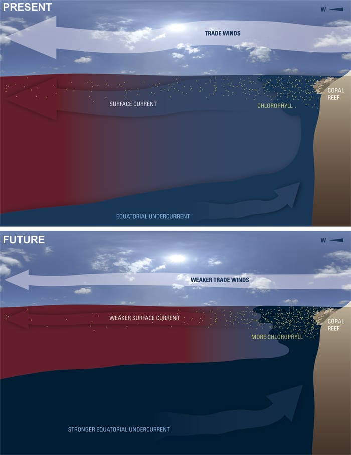
Here’s how it would happen: At the equator, trade winds push a surface current from east to west. About 100 to 200 meters below, a swift countercurrent flows in the opposite direction. This Equatorial Undercurrent (EUC) is cooler and rich in nutrients. When it hits an island, like current hitting a rock in a river, water is deflected upward on the island’s western flank and around the islands. This well-known upwelling process brings cooler water and nutrients to the sunlit surface, creating localized areas where tiny marine plants and corals flourish. (See diagram below.)
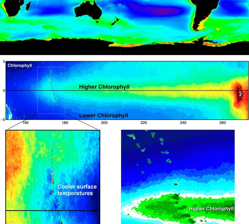
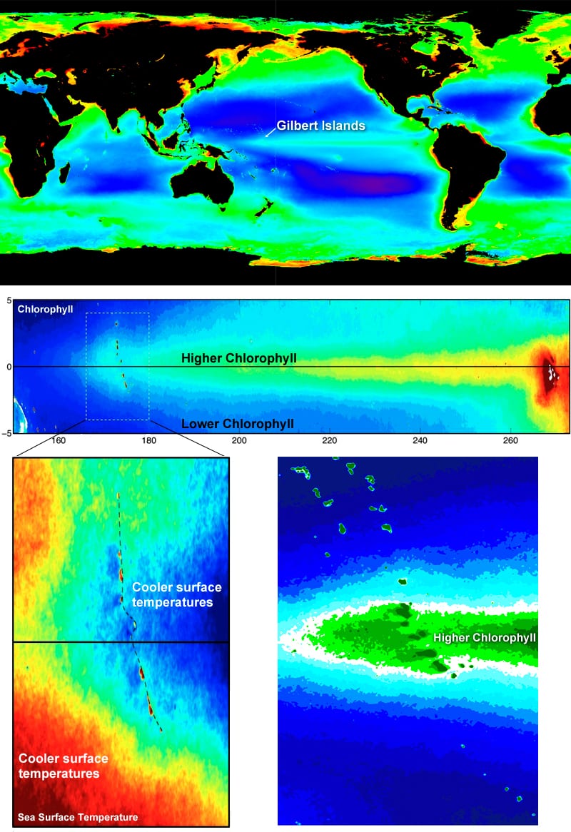
On color-enhanced satellite maps showing measurements of global ocean chlorophyll levels, these productive patches of ocean stand out as bright green or red spots. One of the most prominent occurs around the Galapagos Islands in the eastern Pacific.
But heading westward from the Galapagos, chlorophyll levels fade like a comet tail, giving scientists little reason to look closely at scattered low-lying coral atolls farther west. The islands are easy to overlook because they are tiny, remote, and lie at the far left edge of standard global satellite maps that place continents in the center.
Karnauskas, a climate scientist, was working with WHOI coral scientist Anne Cohen to explore how climate change would affect reefs in the central equatorial Pacific. To familiarize himself with conditions in the area, he examined chlorophyll maps.
When he changed the view of chlorophyll maps on his computer screen to see the entire tropical Pacific at once, he saw that chlorophyll concentrations jumped up again exactly at the Gilbert Islands on the equator. Satellite maps also showed cooler sea surface temperatures on the west sides of these islands, part of the nation of Kiribati.
“I’ve been studying the tropical Pacific Ocean for most of my career, and I had never noticed that,” he said. “It jumped out at me immediately, and I thought, ‘there’s probably a story there.’ ”
Focusing on the fine-scale
So Karnauskas and Cohen began to investigate how the EUC, which runs between 2 degrees (138 miles) north and 2 degrees south of the equator, would affect the equatorial islands’ reef ecosystems, starting with global climate models that simulate impacts in a warming world.
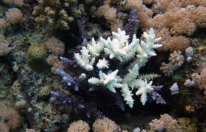
Global-scale climate models predict that ocean temperatures will rise nearly 3°C (5.4°F) in the central tropical Pacific in this century. Warmer waters often cause corals to bleach, a process in which they lose the tiny symbiotic algae that live in them and provide them with vital nutrition.
“Bleaching has been a major cause of coral mortality and loss of coral reef area during the last 30 years,” Cohen said.
But even the best global models, with their planet-scale views and lower resolution, cannot predict conditions in areas the size of these small islands. “The models don’t even ‘see’ them,” Karnauskas said.
So he and Cohen combined global models with a fine-scale regional model to focus on much smaller areas around minuscule islands scattered along the equator. To accommodate the trillions of calculations needed for such small-area resolution, they used the new high-performance computer cluster at WHOI called “Scylla.”
“Global models predict significant temperature increase in the central tropical Pacific over the next few decades, but in truth conditions can be highly variable across and around a coral reef island,” Cohen said. “To predict what the coral reef will experience under global climate change, we have to use high-resolution models, not global models.”
Their model predicts that as air temperatures rise and equatorial trade winds weaken, the Pacific surface current will also weaken by 15 percent by the end of the century. The then-weaker surface current will impose less friction and drag on the EUC, so this deeper current will strengthen by 14 percent.
“Our model suggests that the amount of upwelling will actually increase by about 50 percent around these islands and reduce the rate of warming waters around them by about 0.7oC (1.25oF) per century,” Karnauskas said.
The scientists hope to measure current temperature variations and sample corals around the perimeters of the Gilbert Islands.
“When you look on both sides of the reef, you see huge cross-island variability,” Cohen said. “Corals on the west sides of the islands have different conditions than the east sides, and the west sides ‘see’ the EUC.”
They also plan to study the degrees of connection between the islands, to learn if larvae of corals or fish could disperse across the distances from island to island.
Little islands with big impacts
A handful of coral atolls on the equator, some as small as 4 square kilometers (1.54 square miles) in area, may not seem like much. But Karnauskas’s and Cohen’s results indicate that waters on the western sides of the islands will warm more slowly than at islands that are not in the way of the EUC. That gives the Gilbert Islands a significant advantage over neighboring reef systems, they said.
“While the mitigating effect of a strengthened Equatorial Undercurrent will not spare the corals the perhaps-inevitable warming expected for this region, the warming rate will be slower around these equatorial islands, which may allow corals and their symbiotic algae a better chance to adapt and survive,” Karnauskas said. If the model holds true, then even if neighboring reefs are hard hit, equatorial island coral reefs may well survive to produce larvae of corals and other reef species. Like a seed bank for the future, they might be a source of new corals and other species that could re-colonize damaged reefs.
“The globe is warming, but there are things going on underfoot that will slow that warming for certain parts of certain coral reef islands,” said Cohen.
“These little islands in the middle of the ocean can counteract global trends and have a big impact on their own future, which I think is a beautiful concept,” Karnauskas said.
Slideshow