Where Currents Collide
Nineteen days at sea in the 'graveyard of the Atlantic'
I leaned on my shovel last February, taking a break from clearing our mailbox from a fresh mound of snow. My neighbor sauntered over with a wry grin on his face.
“So, you just got back from a cruise, huh? Some life you have—we’re here digging out from the blizzard of the century, and you’re off on a cruise!”
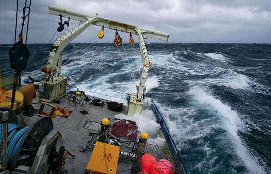
I just smiled. I didn’t want to shatter my neighbor’s image of me as a globe-trotting dilettante. The real story included relentless North Atlantic storms battering our ship, instrument retrievals in the dead of night with blue water washing over the rail, science gear shattered by 20-foot waves. I would rather have been shoveling.
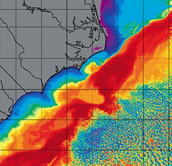
On Jan. 15, 2005, our small science party set out on R/V Oceanus for the tumultuous waters off the coast of North Carolina—aptly nicknamed “the graveyard of the Atlantic.” Led by Woods Hole Oceanographic Institution physical oceanographer Glen Gawarkiewicz, our objective was to study the confluence of southward- and northward-flowing currents that meet at Cape Hatteras. Here the mighty Gulf Stream—warm and salty—breaks away from the coast and heads to Europe—but not before it converges with the “shelfbreak jet,” a strong current at the edge of the continental shelf that carries cold, relatively fresh water from the Arctic and North Atlantic Oceans.
The two water masses have different densities, so they don’t blend seamlessly into each other, but rather collide. Like low- and high-pressure air masses in the atmosphere, these water masses form “fronts,” or boundaries, which continually interact and move in response to passing weather systems.
The shifting of these oceanic fronts creates the equivalent of “weather” within the ocean. They stir up nutrients from the deep to fuel phytoplankton blooms that feed fish and marine mammals. They steer pollutants coming on and off shore. They set up air-ocean temperature gradients that create fog.
To begin to map the dynamics of the oceanic weather in this region, Gawarkiewicz co-led a cruise in August 2004 to take measurements of current speed and direction off Cape Hatteras, as well as water temperatures and salinities, which can distinguish various water masses.
But just as the atmosphere’s dynamics change with the seasons, so do the ocean’s. Now it was time to learn how the water masses mix and create new water masses under the influence of winter cooling and stormier seas.
During our three weeks riding the waves, I kept a journal with pen and camera. These entries will give you an idea of what it’s really like on the high seas off Cape Hatteras in winter.
Jan. 15, 2005: Weather was clear and cold as we steamed south through the Elizabeth Islands. When I told people at WHOI where this cruise was headed, most responded, “Cape Hatteras, in winter?”—followed by a look of acute disbelief and sometimes a sad shake of the head. I know it’s going to be rough, but how bad can it be?
Jan. 17: Just east of North Carolina, the seas could best be described as lumpy. Massive blobs of seawater lurch into the ship, causing it to heave and buck unpredictably. Will Ostrom, a veteran WHOI mooring technician, sways in time to the rolls as I careen into the bulkheads. Will is happily typing away on his computer in the main lab while I stare at the wall fighting nausea. When exactly do I get those “sea legs?” Time to pop the Dramamine.
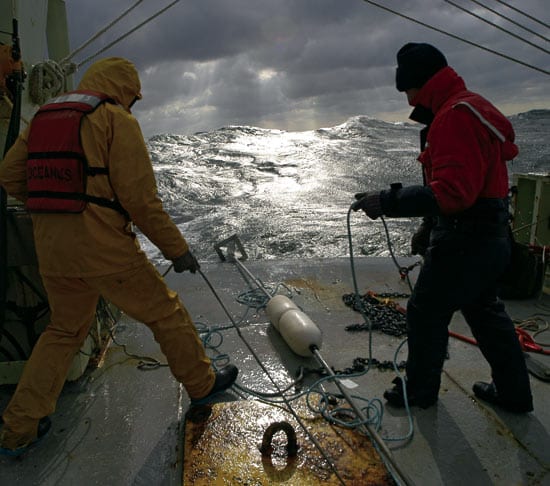
Jan. 18: Tired and wet from putting moorings in the water. Since there are only six scientists and technicians aboard, it was an all-hands operation to get the instruments overboard safely. We deployed a variety of moored instruments: 30-meter (98-foot) lines of tiny temperature probes; a heavy chain mooring, 80 meters (262 feet) long, with temperature probes; several instruments called CTDs to measure conductivity, temperature, and depth; and a large meteorological buoy. The moorings were placed at strategic locations and will be picked up at the end of the two-week cruise.
Each deployment requires a slightly different procedure. Some take 15 minutes, others several hours. Water sloshed across the deck continually as we worked—attaching instruments to the mooring lines, moving heavy anchors, testing acoustic release equipment. My duty involved standing at the starboard rail holding the acoustic release transducer cable over the side while Craig Marquette, an engineer from the WHOI Physical Oceanography Department, tested the releases. For whatever reason, the waves seemed to be drawn to that location. My survival suit was soaked with salt water by the end of the day. Cold salt water.
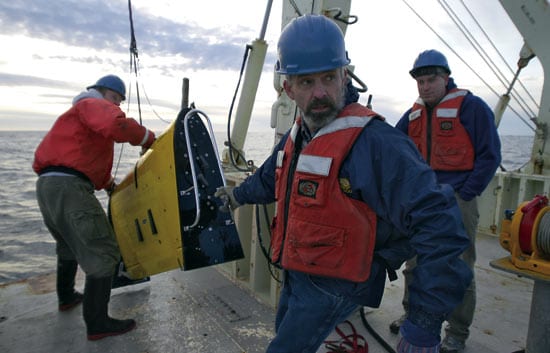
Jan. 19: We have commenced towed vehicle operations, the heart of the project. A wing-shaped vehicle, 2 meters (6 feet) long, called the Scanfish will collect temperature and salinity data as we tow it behind us.
The Scanfish “flies” or undulates behind the ship, giving us a two-dimensional picture of water properties from the surface down to 100 meters (330 feet). Since we don’t have to stop the ship to sample, we are able to measure a large parcel of ocean in a short time.
Brian Kidd from the University of Delaware is our Scanfish expert. In the shallow, placid waters of Delaware Bay, the “fish” flies beautifully. Out here in the towering waves and fast currents of the Gulf Stream, it’s not doing so well. Brian has bags under his eyes. He’s been standing an evening watch and working all day to fix the equipment problems that cropped up overnight.
“We’re running out of parts,” he confides between yawns. “We have never gone through this many spares.” Looks like we might have to make a port call.
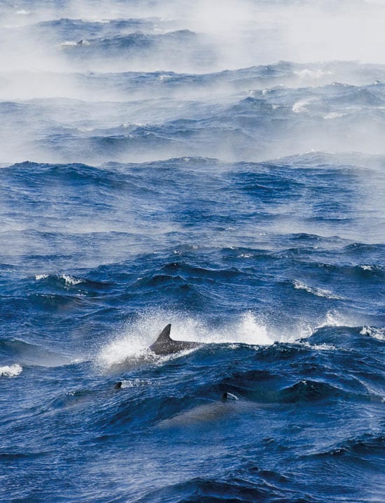
Jan. 21: I go outside to feel a cold wind in my face. A thick fog billows over the waves, caused by the cold northerly air passing over the balmy waters of the Gulf Stream. This “sea smoke” is one of the most beautiful things I have ever seen. The wind whips the fog over the wave crests as dolphins surf the 20-foot rollers. I fight my way up to the bridge for a better look.
As the sun sets, the waves and mist turn gold. The wave crests look like distant mountain ridges. Chief Mate Diego Mello, a Coast Guard veteran, joins me on the flying bridge. “In all my years at sea I’ve never seen anything like this,” he tells me. I feel like the sea has given us a little reward for our determination.
Jan. 22: We pulled into Morehead City, N.C., to pick up some parts for our battered Scanfish and to escape the storm that has just started burying New England with a record-setting snowfall. Thirty-five foot waves are forecast for the Gulf Stream.
Is it only a coincidence that the New England Patriots are playing in the AFC championships this weekend—something we couldn’t watch at sea? Or perhaps it is a morale-boosting decision by the captain and chief scientist?
I’m glad we are not riding this storm at sea, and—back home—my wife is glad, too.
Jan. 26: The familiar hum of the engines was absent when I woke up. After two weeks on the ship, you become attuned to every sound and motion. A quiet ship meant that we weren’t Scanfishing anymore.
The hum and whir of the propellers started up again. The sound of waves slamming into the side of the ship resumed, as did our wild rolls from side to side. Hmm, we must have just finished a CTD cast and are moving on to another station.
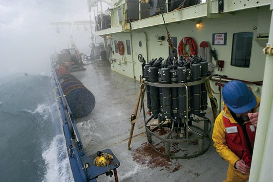
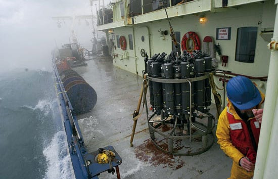
One of the most traditional ocean instruments, the CTD is encased in a metal frame called the rosette, which is lowered over the side using the ship’s winch. In rough seas, two people use slip-lines to keep the 408-kilogram (900-pound) instrument package steady when it’s off the deck. The last thing you want in rough weather is for the CTD to become a wrecking ball. It made for a long night, but the constant activity made time go faster.
Jan. 28: I asked Chris, our steward, why we haven’t had pizza on the cruise. He replied that the ingredients would slide off in the oven.
Our definition of bad weather has changed. Now, 8- to 12-foot seas are considered “calm conditions,” and anything higher is simply “messy.” Work continues night and day. When it’s too rough for the Scanfish, we resort to CTDs. No pizza for us tonight.
Jan. 29: I was heading up to the main lab today when I heard a series of faint whistles and clicks. Initially I thought I must be suffering from one of those “adverse reactions” from exceeding the daily limit of seasickness medication. But when I saw Brian Kidd’s expression, I knew I wasn’t the only one. “Are those dolphins?”
We stepped out on deck and saw several dozen dolphins swimming and leaping out of the water next to the ship. I watched them until sunset. They seemed delighted to find something to play with out in the cold dark ocean.
Jan. 30: Winds have increased to storm force—again. Too rough for Scanfish, too rough for CTDs, too rough for pizza, and too rough for reading in my bunk.
As the ship rolled heavily in the swell, portholes in the main lab alternated between views of the sky and views beneath the waves. As the water swirled around the round porthole, I had an uncanny feeling like I was in a giant steel washing machine.
Sleeping is difficult. With just the right pillow placement, I have managed to wedge myself into my bunk. The sounds of waves crashing into the hull are far from soothing.
This evening we steamed past the moorings to check that they were still there. The anemometer on the guard buoy is dangling from a single mounting bracket—the other one must have broken off. We are hoping it lasts the night.
The forecast for tomorrow looks a little better: only gale-force winds. We can’t wait any longer to get the moorings. If we don’t start pulling them up soon, we might have to head home without them. And then who knows when we would be able to get our precious data?
Jan. 31: Not a good day. In the darkness of early evening, one of the mooring lines got sucked into the propeller as we were retrieving it. It tore the line in half and sent the bitter end zinging back on deck. We are thankful no one was hurt.
The remainder of the mooring line appears to be wrapped around the propeller. I can hear the swish-swish of the line hitting the hull from my stateroom. We have been waiting for a break in the weather to retrieve our largest mooring. Maybe tomorrow.
Feb. 1: Successfully retrieved the large guard buoy mooring. Unfortunately, the anemometer didn’t make it. King Neptune claimed it in the last storm, and with it, all of our wind data.
All the other instruments were retrieved safely, and Craig and I immediately set to downloading the data. After all this hard work, it sure is nice to see those data plots come up on my screen—phew! Almost a 100 percent return from the instruments that made it back. Chief Scientist Glen is ecstatic. We feel like we have won a battle.
Feb. 3: Finally, heading for home (just as I was getting my sea legs, too!). Despite the rough conditions, we managed to make some unique high-resolution measurements of this energetic current system—five Scanfish grids, 71 CTDs, and 11 days of moored instrument data. That data will tell an interesting tale of what goes on beneath the waves as winter storms rage overhead.
Postscript: After arriving in Woods Hole, divers cleared the sundered mooring line from Oceanus’s propeller. Attached to the line was a single temperature probe, which valiantly collected data all the way back to port.
Slideshow
Slideshow
- Veteran seagoing WHOI researchers Craig Marquette (left) and Will Ostrom deploy a mooring with tiny temperature probes from R/V Oceanus during a gale off Cape Hatteras. (Photo by Chris Linder, Woods Hole Oceanographic Institution)
- Off Cape Hatteras, the warm, salty Gulf Stream (red, orange, and yellow) collides with a cold, fresh, southerly coastal current (dark blue), creating ocean "fronts."
- A research expedition aboard R/V Oceanus battled high seas and rough weather off Cape Hatteras in January 2005.
- WHOI engineer Craig Marquette secures the door to the wet lab after recovery of a CTD (on deck).
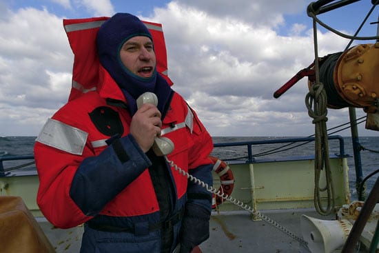
- WHOI physical oceanographer Glen Gawarkiewicz relays information from the bridge to the fantail.
- (Left to right) Brian Kidd of the University of Delaware, and Will Ostrom and Glen Gawarkiewicz of WHOI recover the Scanfish, a towed vehicle that measures temperature and salinity.
- Dolphins cavort amid steep waves and ?sea smoke? off Cape Hatteras. The ?smoke? is created when cold winter air meets the relatively warm waters of the Gulf Stream. (Photo © Chris Linder)

