What Could a Tsunami Network Look Like in the Future?
WHOI engineers develop the next generation of ocean monitoring technologies
The Deep-ocean Assessment and Reporting (DART) system is battle-tested and operational, so it makes sense to use such buoys to address the immediate need for a tsunami network. Researchers at WHOI are concentrating on the next generation of multidisciplinary ocean observing platforms.
“WHOI’s role is to build the new sensors and develop the new technology,” said Bob Detrick, WHOI senior scientist and vice president for marine operations. “Our strength is to build new technology and the new scientific knowledge that agencies like NOAA and broader society can profit from. That’s what we do—we build the new and better mousetrap, the cheaper, more sustainable way of making these observations.”
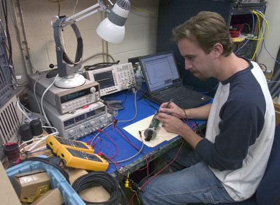
• Researchers from WHOI—including Detrick, Dan Frye, Lee Freitag, and John Collins—the Scripps Institution of Oceanography, and the University of Washington have been working to see if they can use advances in buoy, satellite, and acoustic technology to develop mini-observatories for multiple ocean studies on one mooring string.
A suite of meteorological sensors adorns their surface buoy; a current meter hangs in mid-water on the mooring string; and an ocean-bottom seismometer and two seafloor nodes (for plugging in other instrument packages) rest at the base. Next-generation, high-speed acoustic modems send signals from the ocean bottom to the buoy and, more importantly, from the surface back to the bottom instruments. Transmitters on the surface buoy relay data and commands between shore-based labs and the observatory via the Iridium satellite network.
In May 2004, the team deployed their buoy in Nootka Bay, off Vancouver, British Columbia, for at least one year of data gathering. They have transferred up to 1 megabyte of data per day from the observatory, “pinging” the system four to six times a day for low-resolution data—for the broad overview of activity—and asking for more detailed data sets when an event occurs.
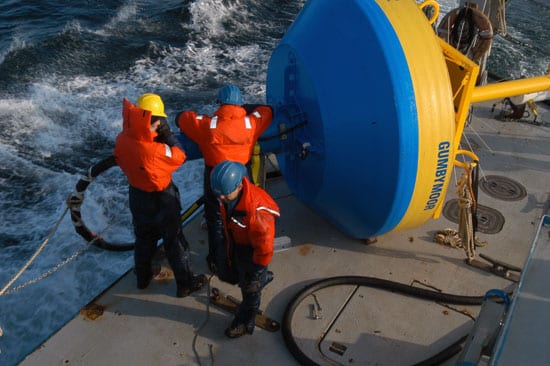
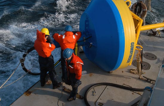
• “Survivability is a big problem with buoys, particularly in coastal waters,” said Frye. “Winds, waves, and currents abuse moorings, so you need a lot of compliance in the lines. But slack mooring lines cause their own problems.”
The solution? Frye and his WHOI colleagues affectionately call it the “Gumby” mooring.
In February 2005, Frye and colleagues began sea trials of a new mooring system to allow scientists to collect real-time seismic data in nearshore waters. The mooring uses ultra-stretchy rubber hoses, reinforced with nylon, that can stretch to twice their unstretched length. These flexible mooring hoses have electrical conducting wires embedded in the walls, making it possible to transmit continuous, high-rate, real-time data from the ocean floor to shore. The system also allows power generated by solar panels on the surface mooring to flow to the bottom instruments.
Instead of a satellite link, the buoy communicates with shore stations via short-range radio signals. And a Global Positioning System receiver on the surface buoy allows the instruments to keep accurate, synchronized time, removing a data processing step and speeding the process of moving crucial information into the global seismic network.
If tests go well, Frye and colleagues plan to deploy the first Gumby mooring off the Caribbean island of Grenada in 2006. That mooring would include an ocean-bottom seismometer and other instruments to detect the flow of magma and other activity in an underwater volcano near the island. Just as scientists monitor activity of Mount St. Helens to predict the next eruption, researchers hope to sense activity in the undersea volcano before it erupts and sends a tsunami toward the island.
• Senior Scientist Alan Chave is working with colleagues from the University of Washington and Scripps Institution of Oceanography to create the “cyber infrastructure” for future cabled seafloor observatories. In a $3.9 million pilot project called Laboratory for the Ocean Observatory Knowledge Integration Grid (LOOKING), the team will develop fiber-optic and wireless networks, web-like services, information protocols, and hardware that will be the backbone for the seafloor ocean observatory movement in ocean science.
“The ability to have instruments on the seafloor communicate with users on shore automatically and seamlessly is critical to the success of ocean observatories,” said Chave. “LOOKING will help us develop and implement those observatory networks.”
Some tsunami facts
The last major tsunami to hit the US mainland occurred in 1964 following an earthquake off Alaska.
The International Tsunami Information Center was established by UNESCO in 1965, following the 1960 Chile tsunami and the 1964 Alaska event.
85 percent of tsunamis occur in the Pacific.
Slideshow