The Riddle of Rip Currents
Scientists investigate how and where these dire beach hazards occur
Stumbling shoulder-deep through crashing waves off a beach in Duck, North Carolina, Melissa Moulton felt like she was in a washing machine.
Breaking swells pounded around her as she mounted scientific instruments to steel pipes embedded in the seafloor, while a powerful rip current jerked her away from the shore.
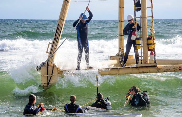
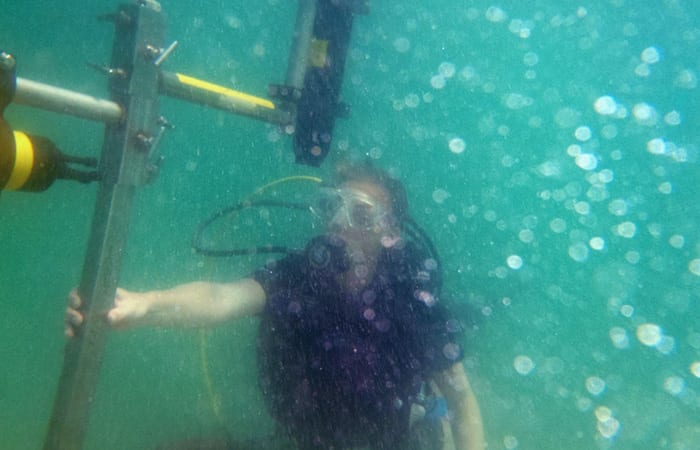
“The surf zone can be a hard place to make measurements,” Moulton said. “The water is shallow, but we use SCUBA gear because it’s hard to hold your breath long enough to deploy or check on instruments, especially when you’re getting knocked back and forth by waves and sometimes pulled in one direction by strong currents. We do our best to stay in place by holding onto our instrument pipes, but it’s common to get carried away from a sensor you’re working on.”
She’d hold on, like a flag flying on a windy day, until a strong rip current won the tug of war and carried her offshore, forcing her to kick and crawl her way back.
It was July 2012, and Moulton was spending the day setting up instruments in the surf zone, the area just offshore where waves break. Moulton, a graduate student in the Massachusetts Institute of Technology/Woods Hole Oceanographic Institution Joint Program in Oceanography, was part of an unprecedented field experiment looking at why, where, and how rip currents form.
While shark attacks and tsunamis do well at the box office, they don’t hold a candle to rip currents when it comes to beach hazards. These narrow, fast-moving jets can sweep offshore faster than Michael Phelps on a Monster beverage binge—up to five miles per hour. They claim more than 100 lives in the United States on average each year, and are the leading cause of lifeguard rescues.
“A lot of times you don’t realize you’re in a rip current,” Moulton said. “You’re getting pushed around by the waves, and you’re just trying to keep your head up and swim back toward shore. You eventually get really tired, realize you’re not making any progress, and start to panic.”
“If you’re caught in a rip, the most important thing to do is to stay calm,” she said. “The rip won’t carry you way out to sea, just outside of the breaking waves. To escape the rip, swim along the beach, out of the current, then back to shore. Or tread water while you wave and shout to get the attention of a lifeguard.”
Carried away
Swimmers aren’t the only things carried offshore by these powerful jets. Rip currents also move mountains of sand and sculpt shorelines. They transport and recirculate pollutants to and from the beach. Rips also play a key role in coastal ecology, serving as critical highways transferring larvae of plankton, invertebrates, and other animals offshore, where they can embark on the next stages of their lifecycles.
As important and ubiquitous as rip currents are, the thrashing surf zone has traditionally been unwelcome territory for studying the underlying physics that create rips. Yet, according to Greg Dusek, an oceanographer with the National Oceanic and Atmospheric Administration (NOAA) and a rip current forecasting expert, direct field observation is key to improving computerized model simulations.
“We are working to operationalize a statistical rip current forecast model here at NOAA,” Dusek said. “Some aspects of rip currents are not well understood, and we need to better understand in a broader sense what conditions lead to rip currents behaving in a certain way. So we look to academia and scientists like Moulton to help validate and strengthen our models, which in turn can help enhance public safety and coastal management.”
That was Moulton’s goal. And as difficult as it was to deploy sensors in the surf, it was nothing compared to the experiment’s main event: producing “man-made” rip currents by dredging a channel as big as an Olympic-sized swimming pool into the seafloor.
Anatomy of a rip current
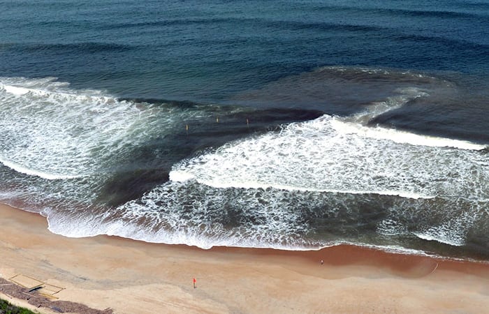
Rip currents occur in sections of the beach where fewer waves break than in neighboring sections. Surfers, who typically enjoy a free ride out to their next set, can usually spot outward-flowing rips by looking for darker patches nestled in between white-foamy breaking waves.
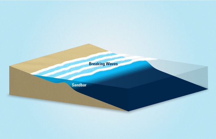
One major cause for differences in where waves do or don’t break is the non-uniformity of seafloor near shore. If you go wading through the surf zone, you’ll often notice both hills and valleys in its underwater topography. Waves tend to break where the water is shallow, but not where there are depressions in the seafloor, like deep channels or gaps in a sandbar.
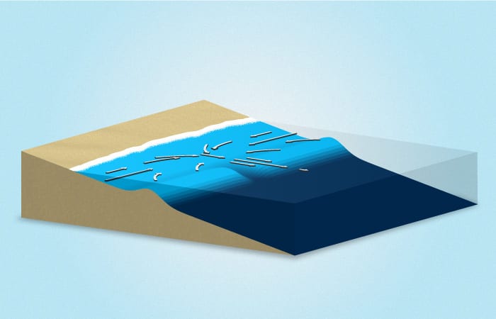
When waves break, they push water into the surf zone and pile it up at the shoreline. If there’s a deep channel, waves break on the shallow sides of the channel—not in it—causing water to pile up unevenly along the beach. Following the path of least resistance, water on the sides of the channel flows toward the low-lying water in the channel. Then it rushes in a torrent through the narrow escape conduit back out to sea. That’s a rip current.
“Breaking waves fill up the surf zone like a bathtub, and the channel acts like a low-pressure drain that water wants to flow out of,” Moulton said.
A generation of change
Moulton’s interest in rip current science traces back to her childhood summers running around the barrier beaches of Chatham, Mass., with her sister and cousins.
“My grandfather collects historical nautical charts and aerial photos of the evolving beaches around Chatham,” she said. “He would talk us through the pictures showing inlets opening and closing, homes getting washed away, and islands forming and disappearing. As I got older, I found myself asking questions like, ‘Why does the beach look so different from year to year, and why do waves break in some spots and crash on the beach in others?’ It wasn’t until college that I realized these were scientific questions.”
As a physics major at Amherst College, Moulton spent time in Vieques, Puerto Rico, studying bioluminescent bays where she began using instruments to measure tidal elevation. The following year, she was accepted into WHOI’s Summer Student Fellowship program and began working with scientists Britt Raubenheimer and Steve Elgar—“people who got to study waves and sand as a job!” she said.
“Melissa had an excellent undergraduate background in a difficult physics curriculum, programming experience, and good skills in the water in terms of swimming, scuba diving, and boat driving,” said Elgar, her Ph.D. advisor. “She was excellent, so I pursued her to come to WHOI for grad school.”
“Coming into the graduate program, I was hooked on the idea that I could use physics, math, and instrumentation to answer environmental questions that are so important to residents, beachgoers, businesses, and the military,” Moulton said.
The big dig
Rip currents only occur when the conditions are right, and they can appear briefly and then disappear for days. Given these difficulties, few studies on rip current dynamics based on field observations have been conducted—or even attempted.
But what if rip currents could be produced on demand?
“To get a dense set of observations, we had to know exactly where rips would form and when,” Moulton said. “So we came up with the novel idea of dredging a big channel right in the surf zone. Once the channel was made, we’d be ready to get right in there and deploy sensors and start gathering data.”
“The idea was that if we took a big dent out of the seafloor by dredging across the surf zone, we’d be able to observe the response of the waves and flows and get a sense for the physics,” she said. “If you can only passively observe what’s going on at the beach, you won’t get as big of a signal to analyze.”
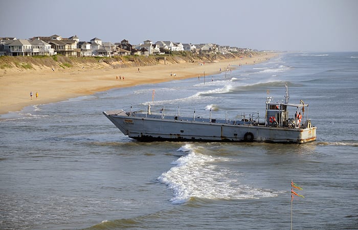
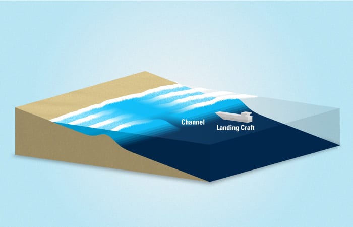
To dig a ditch big enough to induce rips, Moulton and her colleagues at WHOI went to the Field Research Facility (FRF), a former Navy bombing range on a 176-acre beach site in Duck, N.C. The U.S. Army Corps of Engineers converted the beach into a unique natural laboratory to study shoreline phenomena. The team worked with FRF staff to rebuild a 73-foot long landing craft, and enlisted a few brave Army Corps engineers to drive it. Once a window of calm days arrived, they cruised over to a relatively uniform section of the beach, cranked up the twin propellers as they positioned the boat in the surf zone, and began churning up sand with the enthusiasm of teenagers doing donuts in a parking lot.
“I stood there with a GPS unit marking out locations to dredge and telling the pilot where to steer the boat,” Moulton said. “As much as we were trying to carefully sculpt the seafloor, it initially seemed like we were just circling around and stirring stuff up.”
But over time, they got the hang of it, and within four hours the team had dredged a mammoth channel—150 feet long, 90 feet wide, and 6 feet deep—smack dab in the middle of the surf zone.
Hurry up and wait
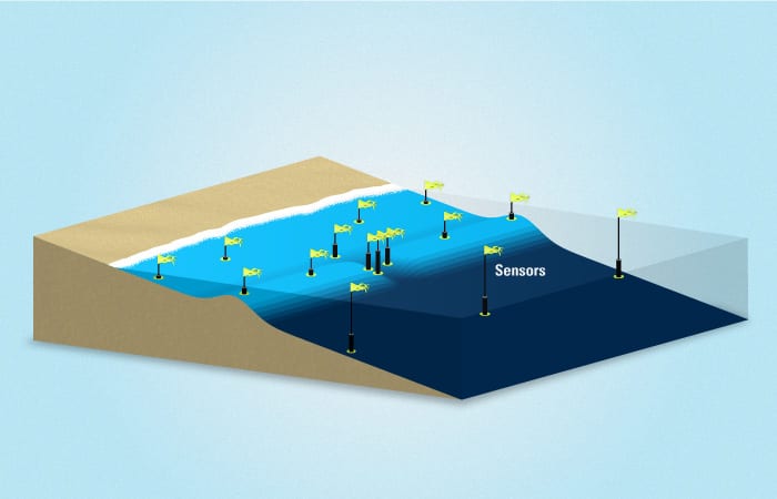
Once the dredging was done, the vessel pulled out and the researchers dove in to install instrument pipes. They did this by fluidizing the sand with a high-pressure hose and pushing the pipes up to eight feet into the seafloor. After securing the pipes, the team began the two-day process of deploying altimeters to record the changing depths and shapes of the seafloor; current meters to measure the speeds and directions of current; and other sensors to measure wave heights and directions and tidal flows.
Everything was finally in place to record all the ins and outs of rip currents. But there was one problem. The ocean was still as calm as a lake. The team waited on the beach for hours, hoping for waves to start breaking and rips to form, before their hard-won, freshly dug channel filled in.
“We saw nothing that entire week, so we had to pull out all the instruments and start the whole process over again a couple of weeks later,” Moulton said.
On their second attempt, they got the channel dug and sensors deployed and started to see some action. But it was in the form of alongshore currents—river-like currents that flow parallel, not perpendicular, to the beach. Still no rips.
It took a few more weeks to get the experiment set up for yet another try. This time, the surf conditions turned from calm to moderate, and it all came together. A huge rip current started flowing through their artificial channel and persisted for 36 hours straight. For Moulton and colleagues, this third time was definitely a charm.
Empirical evidence
The rip current continued flowing seaward through the dredged channel, and the sensors were busy collecting data on wave heights, flows, water pressure, seafloor topography, and tidal elevation. Data were collected for a week before the sensor batteries went dead. At that point, Moulton wrapped up the experiment, downloaded the data, and began to analyze it.
A few observations stuck out. They learned that dredging a channel can generate a huge rip current, even with small-to-medium-sized waves. And, by installing dozens of sensors in the surf zone, they learned that the rip jet was narrower than the channel and wobbled from side to side under certain conditions. They also found that rip currents were strongest at low tide and when waves were coming straight into shore, and that small changes in wave direction cause rips to turn on or off.
“Melissa’s observational work is helping us make our hydrodynamic models better,” Dusek said. “What’s really neat is that she was also able to validate some of what we’ve seen through lifeguard observations. For example, lifeguards have reported surprisingly fast rips at moderate wave heights, and have suggested that waves only three feet high can be pretty hazardous. We are seeing the same thing in Melissa’s data. This helps us know what to tell the public when it comes to beach safety.”
The information will also be used to inform coastal management.
“Rip currents often occur under piers and alongside groins and other shore protection structures,” Moulton said. “And because they carry so much sand offshore, rips change the shape of the beach over time. The more we can learn about the physics of the surf, the better we’ll able to predict which sections of the beach are going to erode so that municipalities, harbor masters, and others can make better management decisions as the coastline changes.”
On the beach
By obtaining this unique set of observations, Moulton and her colleagues have arrived at a better sense for how key factors such as seafloor topography, wave height and angle, and tidal elevation balance to form rip currents. And the study confirmed, once and for all, that when there are waves breaking along the beach and you dig a big enough channel, it drives rips.
Channels drive rips, but do rips make channels?
“It’s an age-old chicken-and-egg question that we plan to focus on as a future part of our study,” Moulton said. “In particular, we’d like to look at what causes channels to form, grow, and disappear, and how those changes relate to the presence of rip currents.”
“It’s a coupled and complicated system, but understanding these dynamics will get us one step closer to more accurate predictions of beach conditions.”
This research was funded by the Assistant Secretary of Defense for Research and Engineering, The National Science Foundation, a National Defense Science and Engineering Graduate Fellowship supported by the Office of Naval Research, and a National Science Foundation Graduate Research Fellowship.
From the Series
Slideshow

Slideshow
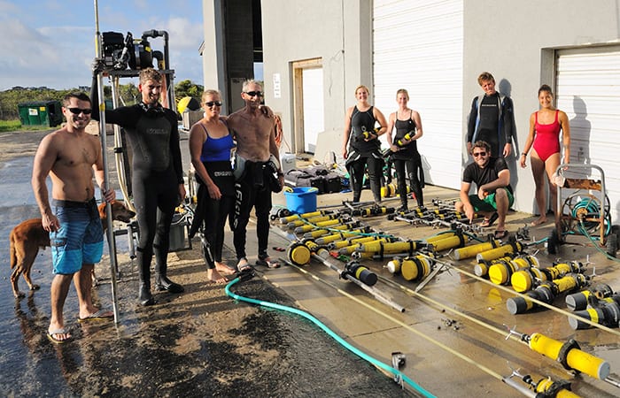
 A day on the beach usually means a hard day's work for members of the PV Lab at Woods Hole Oceanongraphic Institution. Researchers in the lab study the complex dynamics that move water and sand around near the shoreline. From left are Kohl Brinkman, Steve Elgar, Britt Raubenheimer, Liliana Velasquez Montoya, and Melissa Moulton. In this case, they dredged a manmade channel at the beach to create and study rip currents, which can imperil bathers and cause beach erosion. (Jennifer Cole)
- The researchers used a 73-foot-long landing craft to create a mammoth channel—150 feet long, 90 feet wide, and 6 feet deep—in shallow water at a research beach in Duck, N.C. The channel induced the formation of rip currents that the team could study. (Bill Birkemeier, U.S. Army Corps of Engineers Field Research Facility)
- The researchers assemble an array of sensors to install in and around the channel they dug to study rip currents. The sensors collect data on wave heights, flows, water pressure, seafloor topography, and tidal elevation. From left, Jeff Hansen, Seth Zippel, Britt Raubenheimer, Steve Elgar, Jenna Walker, Melissa Moulton, Levi Gorrell, Danik Forsman, and Christen Rivera-Erick. (Bill Birkemeier, U.S. Army Corps of Engineers Field Research Facility)
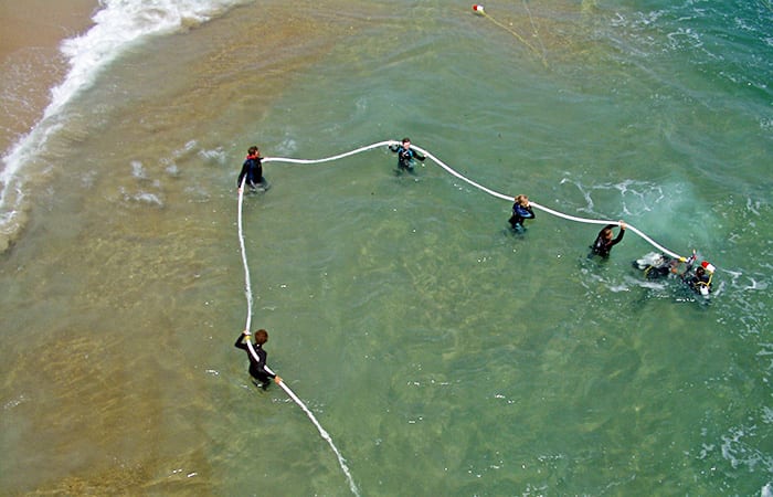
- The research team uses a high-pressure hose to fluidize sand on the seafloor so that they could push pipes up to 8 feet into the seafloor. Once the sand solidifies, they attach their sensors to tops of the pipes. From left are Seth Zippel, Levi Gorrell, Regina Yopak, Britt Raubenheimer, Steve Elgar, and Dana Kurtz. (Evan Williams, Woods Hole Oceanographic Institution)
- Working amid constantly breaking waves, the researchers use SCUBA gear and a staging platform to install sensors that collect data on rip currents. In the surf, from left, are Brandon Grant, Britt Raubenheimer, Kohl Brinkman, and Regina Yopak. On the platform, from left, are Levi Gorrell and Melissa Moulton. (Dave Clark, Woods Hole Oceanographic Institution)
- “The surf zone can be a hard place to make measurements,” said MIT-WHOI graduate student Melissa Moulton. “We use SCUBA gear because it's hard to hold your breath long enough to deploy or check on instruments, especially when you're getting knocked back and forth by waves and sometimes pulled in one direction by strong currents.” (Steve Elgar, Woods Hole Oceanographic Institution)
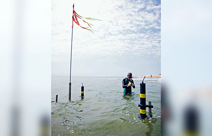
- As tides rise and ebb, flags mark the locations of sensors deployed along the shoreline to collect data on wave heights, water speed and directions, water pressure, seafloor topography, and tidal elevation. (Jennifer Cole)
- Waves tend to break where the water is shallow, atop sandbars for example, but not where the water is deep. (Illustration by Eric S. Taylor/Woods Hole Oceanographic Institution Graphics Services)
- WHOI researchers used a 73-foot-long landing craft to create a 150-foot-long, 90-foot-wide, and 6-foot-deep channel interrupting a sandar at a research beach in Duck, N.C. The channel induced the formation of rip currents that the team could study. (Illustration by Eric S. Taylor/Woods Hole Oceanographic Institution Graphics Services)
- To study the dynamics of rip currents, the WHOI researchers installed arrays of sensors near the channel to collect data on wave heights, flows, water pressure, seafloor topography, and tidal elevation. (Illustration by Eric S. Taylor/Woods Hole Oceanographic Institution Graphics Services)
- Waves break on the shallow sides of the channel—not in it—causing water to pile up unevenly along the beach. Following the path of least resistance, water on both sides of the channel flows swiftly toward the low-lying channel. Then it rushes in a torrent through the narrow escape conduit back out to sea. That’s a rip current. (Illustration by Eric S. Taylor/Woods Hole Oceanographic Institution Graphics Services)
Video
Related Articles
- The ocean currents behind Brazil’s pollution problem
- How is human health impacted by marine plastics?
- Sunlight and the fate of oil at sea
- A toxic double whammy for sea anemones
- WHOI scientists discuss the chemistry behind Sri Lanka’s flaming plastic spill
- Oil spill response beneath the ice
- Fukushima and the Ocean: A decade of disaster response
- WHOI scientist shares her perspective on ‘imminent’ oil spill in the Red Sea
- WHOI establishes new fund to accelerate microplastics innovation
