Ocean Observatories Initiative Poised to Launch
WHOI wins grant to lead national effort
Woods Hole Oceanographic Institution (WHOI) was awarded a $97.7 million grant to help build a decades-long dream of ocean scientists: networks of ocean observatories that can monitor conditions in critical coastal and remote open-ocean locations and provide a continuous flow of data in near-real time to scientists and marine resource managers onshore.
The grant helps launch the Ocean Observatories Initiative (OOI), a $300 million project funded by the National Science Foundation (NSF) to build, implement, and operate coordinated systems of moored buoys, undersea cabled networks, and autonomous underwater vehicles—all instrumented to collect data on the inner workings of ocean currents, ocean ecosystems, seafloor processes, and air-sea interactions that influence weather and climate.
The OOI includes observatory systems to study coastal ocean regions; a global ocean network; a cabled regional observatory extending off the Pacific Northwest coast; and a cyber-infrastructure component to collect and disseminate data.
“When these systems are operational, we’ll be able to build a picture of ocean interactions that we’ve never had before,” said Bob Weller, principal investigator of the coastal and global components of the OOI, which WHOI will lead.
“Scientists will have the flexibility to remotely control their instruments in response to events in the ocean and instantly receive the data,” he said. “This view of the ocean will be accessible not only to scientists, but to policymakers, educators, students, or anyone curious about the ocean.”
Harnessing new technology
Funds for the project will be dispersed through WHOI to collaborators: Scripps Institution of Oceanography at the University of California, San Diego, and Oregon State University’s College of Oceanic and Atmospheric Sciences. NSF is now supporting design and preparations in advance of construction, now planned for mid-2010, pending reviews and the availability of federal funds in the 2010 budget.
The award was announced Aug. 23, 2007, by the Joint Oceanographic Institutions division of the Consortium for Ocean Leadership, the or-ganization managing the observatory initiative for NSF. Construction for the OOI will be matched by an additional $10 million from the Commonwealth of Massachusetts’ John Adams Innovation Institute, a program of the Massachusetts Technology Collaborative.
“It’s impossible to overestimate the value of this project to the future of oceanography,” said then WHOI President and Director Jim Luyten. “By capitalizing on and pushing advances in technology, the OOI will revolutionize the way we observe and understand the ocean.”
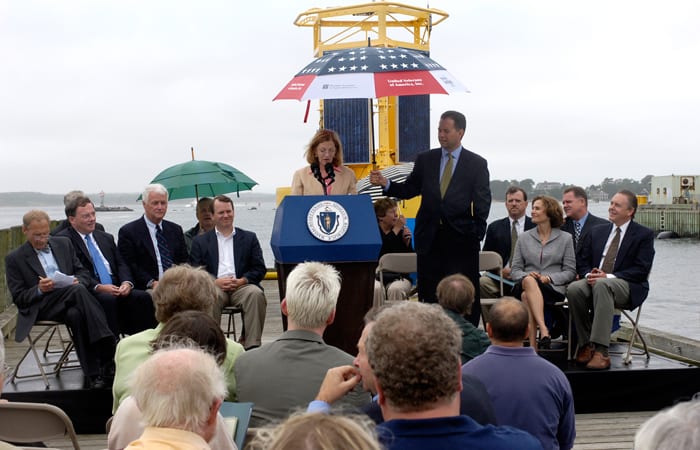
“Technology and access have always been the limitation to fully observing and understanding the oceans and the life they support,” Luyten told an audience at a press conference on WHOI’s Dyers Dock, which featured Massachusetts Lt. Gov. Tim Murray and U.S. Rep. William Delahunt. “But this initiative puts researchers on the threshold of changing that, overcoming the limitations of ship-based work and the chal-lenge of sampling in both space and time.”
Global, coastal, and regional observatories
The global component includes the design and installation of several buoys, distributed in remote high-latitude locations in both the Northern and Southern Hemispheres where critical ocean- and climate-related phenomena take place. The moorings will be outfitted with instru-ments to take measurements from the sea surface and through the ocean depths. The buoys will transmit data via satellite and power themselves using solar and wind generators.
“A major goal of this effort is to better understand and predict the impact of climate change on the interlinked ocean-atmosphere system, and on marine ecosystems, and biodiversity especially in remote, poorly sampled parts of the world’s ocean,” Weller said.
The OOI coastal component includes development of observatories in coastal waters off New England and the Pacific Northwest. These coastal arrays aim to help scientists understand complex coastal ecosystems; the critical role the coastal ocean plays in the ecology and biogeo-chemistry of the world’s oceans; coastal hazards; and the impact of climate change on the coastal ocean.
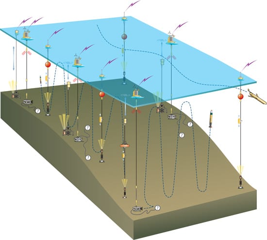
At the heart of the New England coastal observatory is the “Pioneer Array,” a system of surface moorings with instrument packages called profilers that move up and down mooring lines, taking measurements through the ocean depths. Data from these cutting-edge, self-powered moored systems will be integrated with survey information collected by gliders and rechargeable underwater vehicles, giving scientists the ability to study the ocean in three dimensions over long time periods. At the base of the moorings, the vehicles will be able to plug into docking stations to download data and recharge their batteries.
The array will be sited 90 nautical miles south of Cape Cod near the edge of the continental shelf, where shallow continental shelf waters mix with the deep ocean. The observatory will help scientists better understand the complicated biological, chemical, and physical interactions that occur at what is known as the shelf-break front.
“This observing system will allow us to visualize and analyze the evolution of a complex frontal zone in a completely new way,” said Al Plueddemann, a WHOI physical oceanographer who will serve as project scientist for the Pioneer Array. “We will be working with a continu-ous, three-dimensional movie of ocean processes rather than the two-dimensional snapshots available with conventional approaches.”
The initiative’s Pacific Northwest coastal observatory, led by partners at Oregon State University, will deploy a series of permanent moorings called the “Endurance Array.” At two of three sites, moorings will be attached by cable to the cabled observatory of the Pacific Northwest. The moorings will be complemented by undersea gliders programmed to patrol near-shore waters, collect a variety of data, and transmit them to onshore laboratories. The Endurance Array will be located in an area, between the open Pacific Ocean and the coastline, that includes rich habitats for marine life, methane fields, storm-induced waves that have caused erosion, and a subduction zone capable of producing large earthquakes and tsunamis.
Data collected from the coastal observatories will enable more accurate weather forecasts, storm prediction, and improved assessments of the impacts of longer-term climate change on the region. It will also provide information for better management of commercial fisheries, prediction of harmful algal blooms, and mitigation of hazards from oil spills or coastal storm inundation.
Libby Signell, who was hired by WHOI as the observatories project manager, estimates the project will employ 30 people at WHOI—a mix of new and existing employees—over the five-year construction period. The contract also includes options for the first five years of op-erations and maintenance of the installations.
From the Series
Slideshow

Slideshow
- A proposed coastal observatory would include arrays of moorings, working in concert with underwater vehicles and docking stations, to monitor ocean conditions continuously and relay information to shore. (Illustration by Jack Cook, Woods Hole Oceanographic Institution)
- Federal, state, and academic dignitaries (including Mass. Senate President Therese Murray, at the podium) gathered on WHOI's Dyers Dock in August at a news conference announcing a $97.7 million grant to WHOI to spearhead a major U.S. initiative to build ocean observatory networks. (Photo by Dave Gray, Woods Hole Oceanographic Institution)
Related Articles
- Navigating new waters
- On the Move
- From Northern California to Ocean Engineer
- In the Ocean Twilight Zone, Life Remains a Mystery
- New glider design aims to expand access to ocean science
- Gift enables new investments in ocean technologies
- Can seismic data mules protect us from the next big one?
- Life at the Edge
- Ocean Observatories Initiative

