Detours on the Oceanic Highway
Student examines leaks from a great deep-sea current
Within the ocean, there’s a global highway system of currents. It transports heat across the planet, from the equator to the poles. If not for these currents, the equatorial ocean would be a scalding hot tub and the polar regions would freeze solid.
Imagine the Earth as a poorly insulated apartment—a railroad flat with three rooms. The kitchen in the middle is heated by a woodstove, but the two unheated outlying bedrooms can get cold. Earth’s kitchen is the equatorial region, heated by sun; the far-flung poles are its chilly bedrooms.
But open the doors between rooms in the apartment, and warm air moves out from the middle room and heats up the bedrooms a little, while colder air circulates in and cools the kitchen. Our ocean works essentially the same way, but rather than air, great ocean currents circulate excess equatorial heat to the poles.
In the North Atlantic, for example, the Gulf Stream carries water warmed at the equator toward the North Pole. When the warm water meets frigid winter air in northern latitudes, it cools vigorously. Water becomes denser as it cools, and consequently sinks thousands of meters below the sea surface. This deep mass of cold water drifts southward in a current that hugs North America’s continental slope on the western side of the Atlantic Ocean basin: the Deep Western Boundary Current.
These currents are major cogs in our planet’s heating and ventilation system that regulate Earth’s climate. To understand how our climate works and unravel how it will change, we need to reveal the inner workings of these currents.
A mathematical ocean
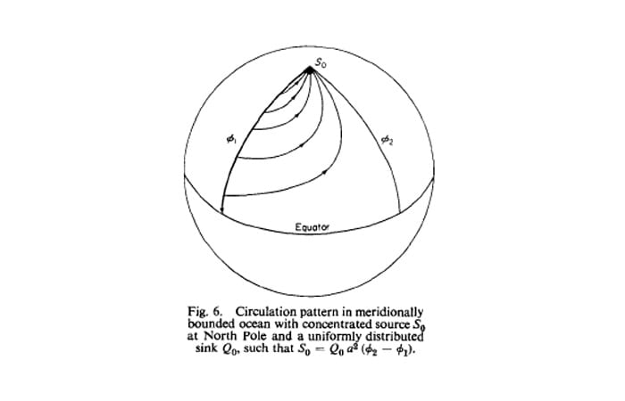
As recently as 50 years ago, the Deep Western Boundary Current remained undiscovered. Oceanographers knew that water must be sinking at high latitudes, but they did not have the means to observe where it went. In the early 1960s, two scientists at Woods Hole Oceanographic Institution (WHOI), Henry Stommel and Arnold Arons, used mathematics to explore deep-sea circulation. Reducing the problem to its bare essentials, they conceived of an idealized ocean that looked more like a bathtub. It had straight walls, a flat bottom, and water sinking at the ends of the tub, which represented the real-world polar oceans.
In this theoretical model, they calculated the essential physical forces acting on the flow of water in bounded basins on a rotating sphere. Their calculations pointed to the existence of the Deep Western Boundary Current. A few years later, English oceanographer John Swallow and Val Worthington at WHOI placed floats in the ocean. The floats were swept equatorward by the Deep Western Boundary Current, confirming what Stommel and Arons had predicted by mathematical equations alone.
Physical oceanographers have continually used this combination of observations and models to push forward our understanding of ocean dynamics. Models are mathematical approximations of reality that can distill the essence of the physics at work and help us explore how the world operates. Observations confirm the reality and unveil new complexities that require further explanation.
Tollbooths on the ocean highway
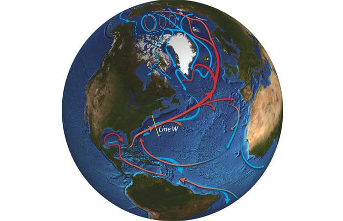
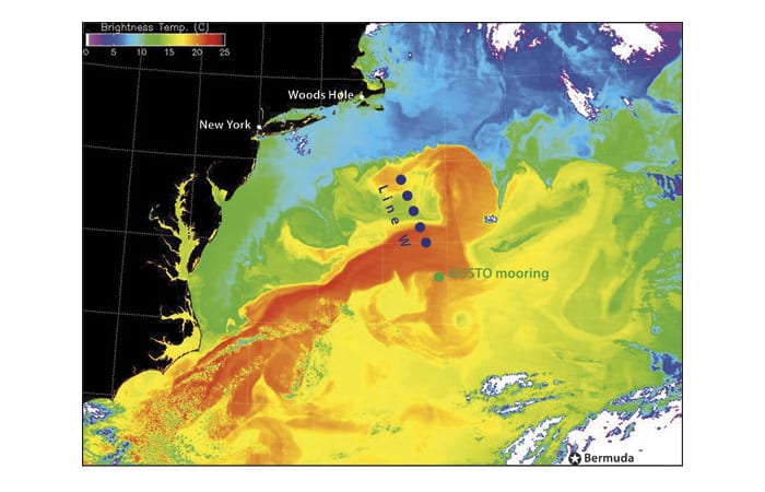
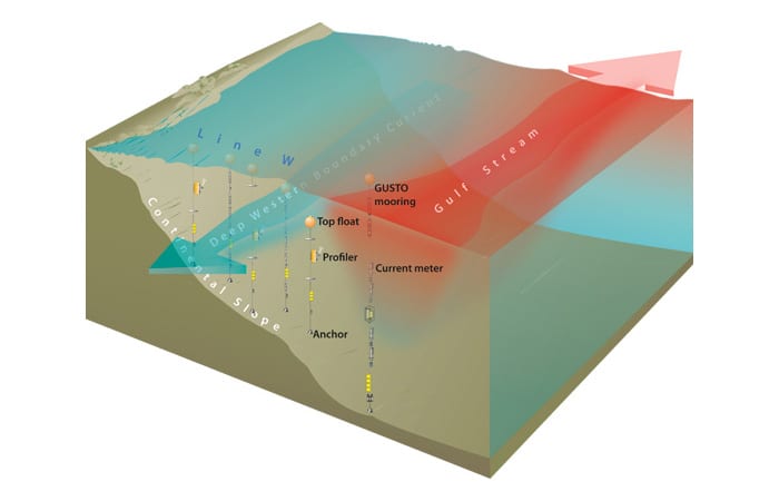
One important set of observations has come from Line W, where scientists at WHOI have been measuring the strength of the Deep Western Boundary Current in the North Atlantic since 2004. Line W consists of a series of six moorings that starts at the continental slope off Cape Cod, Mass., and heads southeast. Moorings consist of cables as tall as ten Empire State Buildings. The cables are anchored to the ocean floor and held upright by buoyant glass spheres. Instruments called moored profilers ride up and down along the cables, measuring the temperature, salinity, depth, and velocity of the water as it flows by.
The Line W moorings are like oceanic tollbooths. But instead of collecting a fee, they are measuring the strength and properties of the Deep Western Boundary Current as it flows past.
Line W is a way to observe and document changes in the current, which may be linked to changes in global heat transport. Such observations may give us insights into how Earth’s changing climate is affecting the ocean, and vice versa.
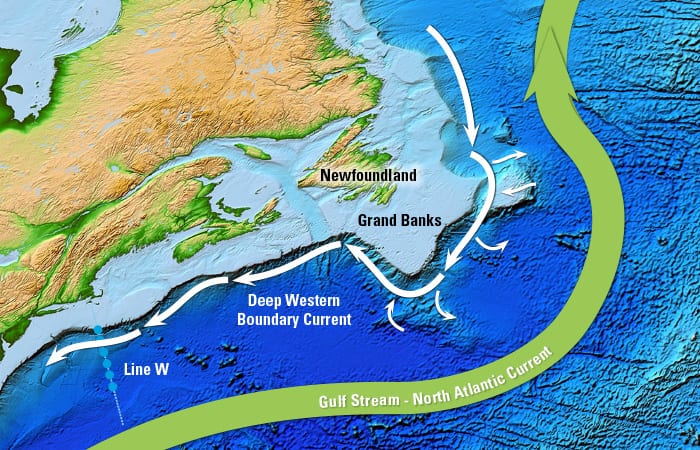
Detour at the Grand Banks
On the theoretical large-scale model conceived by Stommel and Arons, the Deep Western Boundary Current is the main oceanic highway directing cold, dense water southward in the North Atlantic—much the way Interstate 95 steers traffic on the U.S. Eastern Seaboard.
But the real ocean is far more complex. It is full of sharp curves and detours—underwater mountains, continents that jut out, and swirling eddies, all of which can divert water out of the Deep Western Boundary Current. If that water were cars, we might not be counting all the cars heading south at the Line W tollbooths; the measurements at Line W may not be telling us the full story.
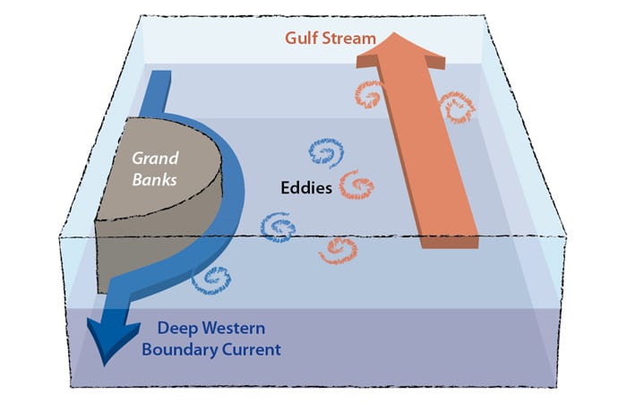
In the last decade, scientists Amy Bower of WHOI and Susan Lozier of Duke University have been using floats to track the southward flow of deep water from the North Atlantic. They have observed that many floats seem to get off the Deep Western Boundary Current highway.
One potential detour spot may be at the Grand Banks of Newfoundland, where the coastline takes a series of sharp turns. Something may be happening at this juncture that affects the watery traffic downstream, and that’s what I am trying to figure out.
Back to fundamentals
So I am taking a page from Stommel and Arons’ book. I am proposing to strip the problem down to its essential elements. I hypothesize that water leaves the Deep Western Boundary Current at the Grand Banks because of two primary features.
The first feature is the bend in the coastline. The current could have trouble rounding the curve and in response, create eddies that spin out and carry water away from the current.
The bend also directs the Deep Western Boundary Current close to the other key feature: the Gulf Stream-North Atlantic Current system, which flows near the surface above the Deep Western Boundary Current at ten times the speed.
The energetic Gulf Stream spins up many eddies that can peel off northward into the Grand Banks region. These eddies of Gulf Stream water may collide and mix with waters in the Deep Western Boundary Current, changing their salinity, temperature, and density, and causing some water to leak out of the boundary current.
Manipulating my model ocean
I am creating a mathematical model that focuses on just the three components that I think matter most: the Deep Western Boundary Current, the bump in the coastline that affects it, and the Gulf Stream. The model is made up of two layers, with the Deep Western Boundary Current in the lower layer and the Gulf Stream in the upper layer.
The equations in the model simulate the dynamics of the ocean and generate eddies in my idealized ocean off Newfoundland where the currents are influenced by the topography. I conduct numerical experiments by manipulating the strengths and configurations of the three key components and seeing what effects these manipulations produce. Over time, I should be able to tease apart why water is diverted from the Deep Western Boundary Current.
Once we have a better understanding of these places where water leaves the current, we can apply that knowledge to refine our measurements of oceanic heat transport. And then we can turn to the bigger questions: How do these diversions from the Deep Western Boundary Current affect the global transport of heat? What impacts could Earth’s changing climate have on the ocean’s interglobal current system? And how could that, in turn, cause further changes in our planet’s climate?
This research was funded by the National Science Foundation.
Slideshow