Cruise
Log: Monday, March 22, 2004
|
March
|
|
Sun
|
Mon
|
Tue
|
Wed
|
Thu
|
Fri
|
Sat
|
|
|
1
|
2
|
3
|
4
|
5
|
6
|
|
7
|
8
|
9
|
10
|
11
|
12
|
13
|
|
14
|
15
|
16
|
17
|
18
|
19
|
|
|
|
22
|
|
|
|
|
|
|
|
|
|
|
|
|
|
|
April
|
|
|
|
|
|
|
|
|
|
|
|
|
|
|
|
|
|
|
|
|
|
|
16
|
17
|
|
18
|
19
|
20
|
21
|
22
|
23
|
24
|
|
25
|
26
|
27
|
28
|
29
|
30
|
|
|
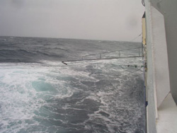 |
| View
from the starboard side showing the rough conditions encountered.
The line dragging behind is to provide underway water samples
for analysis. (Photo by Murray Smith) |
|
| |
Finding
the spot
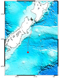 |
The
location of the R/V Tangaroa on March 22, 2004 at 02:00:01.
Position: 47 28. 48S 173 00. 00E.
|
Contributor: Ed Abraham, NIWA
We spent the last
day and night running a transect south through the site where we hope
to make the release. This survey will last for a few days, as we determine
what is going on in the surface ocean. Initial results confirm that the
iron in the seawater is low, and that there are enough of the other nutrients
needed for a bloom to form. It is also important for us to find a place
where the currents are relatively weak, so that the fertilised patch doesn't
get swept away. There is a sharp front to the south, that we will avoid.
Somewhere near 47°S, 173 °E is looking like a good candidate for
the iron release site.
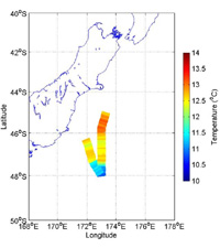 |
| The
track of the ship over the last 36 hours. The colour indicates the
temperature of the sea surface water. The water at the mid temperatures,
between 12 and 13 °C, is low in iron, but with enough of the other
nutrients needed to sustain a bloom. (Credit: Ed Abraham) |
Meanwhile, the weather
has given up on being nice to us, the wind is up and we are all having
to get used to the rolling and pitching of life at sea. There are problems
with some of the equipment needed for the release, so we will shelter
in Dunedin tomorrow, and use the time to sort out the faulty gear. Next
Day >>
 |
| Contributor
Ed Abraham |
|
