Cruise
Log: Tuesday, April 13, 2004
|
March
|
|
Sun
|
Mon
|
Tue
|
Wed
|
Thu
|
Fri
|
Sat
|
|
|
1
|
2
|
3
|
4
|
5
|
6
|
|
7
|
8
|
9
|
10
|
11
|
12
|
13
|
|
14
|
15
|
16
|
17
|
18
|
19
|
|
|
|
|
|
|
|
|
|
|
|
|
|
|
|
|
|
|
April
|
|
|
|
|
|
|
|
|
|
|
|
|
|
|
|
|
|
|
|
13
|
|
|
16
|
17
|
|
18
|
19
|
20
|
21
|
22
|
23
|
24
|
|
25
|
26
|
27
|
28
|
29
|
30
|
|
|
| |
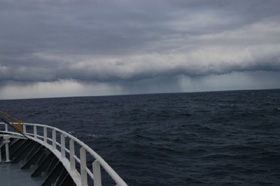 |
| Approaching
storm (Photo by Bill Main). |
| |
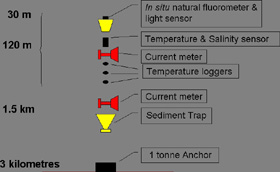 |
Instruments
on the moorings (Credit: Scott Nodder).
|
| |
| |
| |
| |
| |
| |
| |
| |
| |
| |
| |
| |
| |
| |
| |
 |
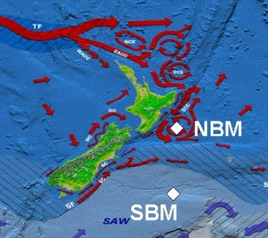
| The
two mooring sites lie in quite different ocean types: sub-Antarctic
water in the south, and subtropical water in the north (Credit: NIWA).
|
Get
More Go on Moorings
Contributor: Scott Nodder
Sometimes the God
of the Sea, Tangaroa, plays a vital role in deciding the milestones and
outcomes of oceanographic voyages. Yesterday was a case in point with
strong westerly winds and a heavy, rough sea, which prevented us from
recovering and redeploying one of NIWA's two deep ocean biophysical time-series
moorings. These have been deployed in the open ocean east of New Zealand
over the last 3 ½ years. This was the first time we haven't been
able to service them which is remarkable considering the sometimes hostile
environment we are working in. The northern mooring is located about 300
km southeast of Napier in subtropical waters, while the southern mooring
is situated on the southern slope of the Bounty Trough about 700 km due
east of Dunedin in the subantarctic zone.
Both of the steel wire moorings stretch from near the sea surface to the
seafloor at water depths of about 3 kilometers. They comprise various
instruments placed at specific depths to collect information on biological,
chemical and physical parameters throughout the water column. The instruments
can be deployed on the moorings for periods of months to years. Near the
sea surface, fluorometers and light meters provide data on plant biomass
and productivity, and temperature and salinity loggers record changes
in the physical properties of the water over time. Current meters measure
the speed and direction of currents and help us understand the dynamics
of water masses in the area. These data provide valuable information on
how physical and biological processes are coupled in surface waters, and,
specifically, help us to determine the seasonality of marine algal (phytoplankton)
production in the oceans around New Zealand. Generally, production peaks
in spring in subtropical waters and in summer in subantarctic waters.
Once nutrient levels are depleted to an extent that phytoplankton production
rates cannot be sustained, the particles sink out of the surface ocean.
These sinking particles are captured by a sediment trap deployed on the
mooring at a depth of 1500 meters. This instrument collects particles
in a large funnel under which a set of bottles are rotated sequentially
to allow a time-series of particle "rain" rates to be estimated.
Combined with information of particle production rates in surface waters,
as determined from the near-surface fluorometers, these sediment trap
data allow us to determine how quickly organic material is decomposed
during its descent through the water column. This information means that
we can construct inventories of important elements, like carbon and silica,
in the ocean and make estimates of how much carbon is being sequestered
into the deep ocean. This is also important in determining how much is
available as food for deep ocean mid-water column and benthic communities,
including economically important animals, such as deep-sea fish. We are
now heading north with the expectation of a more successful recovery and
redeployment of the northern mooring. Next Day>>
|