
Urban civilization rose in Southern Mesopotamia on the back of tides
 The Great Ziggurat of Ur dedicated to the Moon god. Ziggurats were massive structure
typical for Mesopotamia. Sumerians believed that the gods lived in the temple at the top of
the ziggurats. (Photo credits: Reed Goodman, Clemson University)
The Great Ziggurat of Ur dedicated to the Moon god. Ziggurats were massive structure
typical for Mesopotamia. Sumerians believed that the gods lived in the temple at the top of
the ziggurats. (Photo credits: Reed Goodman, Clemson University) August 20, 2025
Photos available for use with credit can be found here.
Woods Hole, Mass. (August 20, 2025) -- A newly published study challenges long-held assumptions about the origins of urban civilization in ancient Mesopotamia, suggesting that the rise of Sumer was driven by the dynamic interplay of rivers, tides, and sediments at the head of the Persian Gulf.
Published today in PLOS ONE, the study, Morphodynamic Foundations of Sumer, is led by Liviu Giosan, Senior Scientist Emeritus in Geology & Geophysics at the Woods Hole Oceanographic Institution (WHOI), and Reed Goodman, Assistant Professor of Environmental Social Science at Baruch Institute of Social Ecology and Forest Science (BICEFS), Clemson University.
The research introduces a novel paleoenvironmental model in which tidal dynamics influenced the earliest development of agriculture and sociopolitical complexity in Sumer. Results are a contribution to the long-running Lagash Archaeological Project, a collaboration led by Iraqi archaeologists and Penn Museum at the University of Pennsylvania.
“Our results show that Sumer was literally and culturally built on the rhythms of water,” said Giosan. “The cyclical patterns of tides together with delta morphodynamics -how the form or shape of a landscape changes over time due to dynamic processes - were deeply woven into the myths, innovations, and daily lives of the Sumerians.”
Sumer was an ancient civilization located in southern Mesopotamia, in what is now modern-day Iraq. It is often considered the cradle of civilization due to its numerous innovations, including the invention of writing, the wheel, and organized intensive agriculture. Sumerian society was structured into city-states like Ur, Uruk, or Lagash, each with its own ruler and religious institutions.
The study shows that from about 7000 to 5000 years ago, the Persian Gulf extended farther inland, and tides pushed freshwater twice daily far into the lower reaches of the Tigris and Euphrates. The scholars propose that the early communities must have harnessed this dependable hydrology using short canals to irrigate crops and date groves, enabling high-yield agriculture without the need for large-scale infrastructure.
As rivers built deltas at the head of the Gulf, tidal access to the interior was cut off. The resulting loss of tides likely triggered an ecological and economic crisis—one that required an ambitious societal response. The extensive works for irrigation and flood protection that followed ultimately came to define the golden age of Sumer.
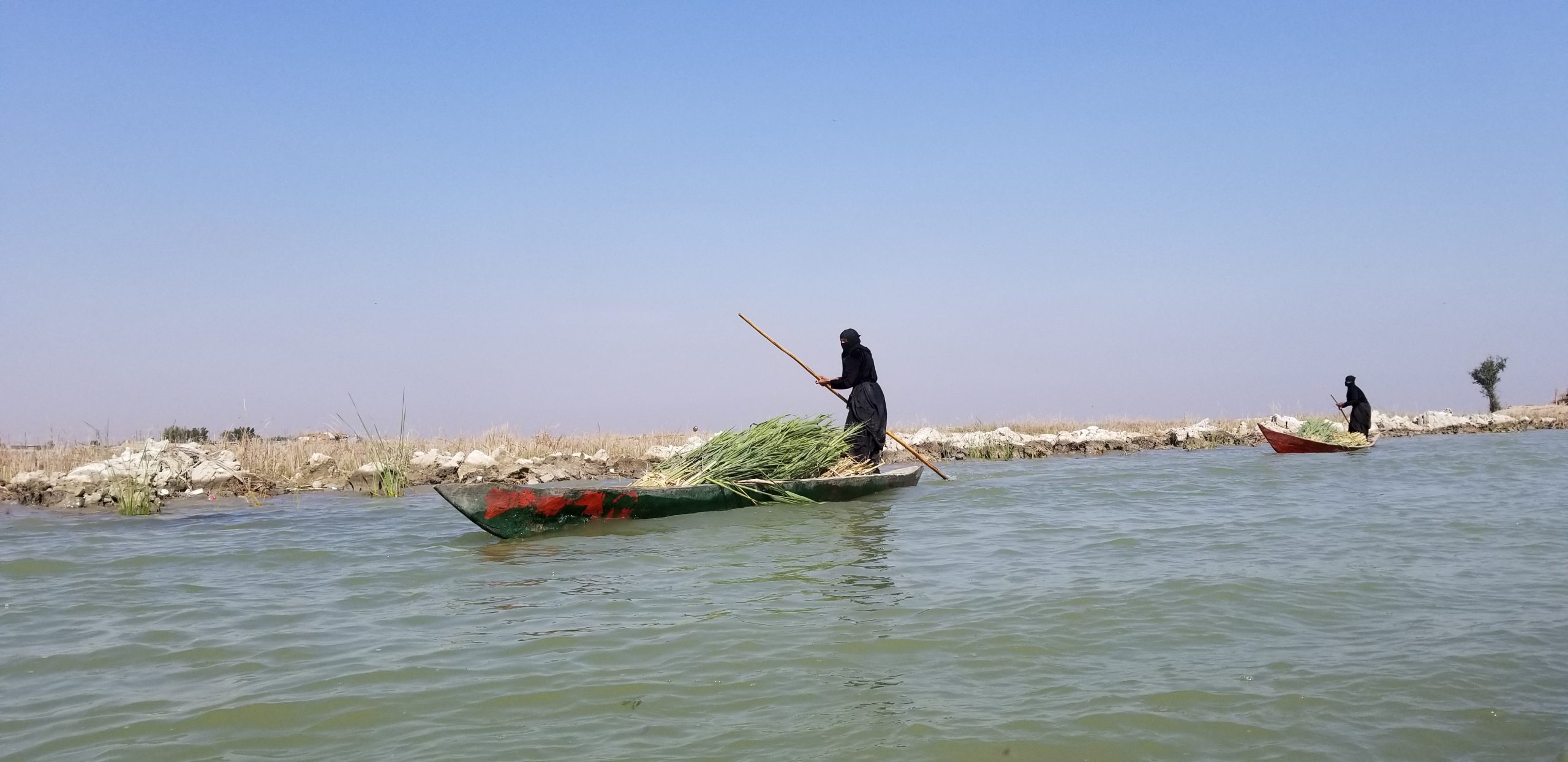
Iraqi Marsh Arabs poling mashoofs, traditional canoes, loaded with freshly cut reeds.
(Photo credits: Reed Goodman, Clemson University)
“We often picture ancient landscapes as static,” says Goodman. “But the Mesopotamian delta was anything but. Its restless, shifting land demanded ingenuity and cooperation, sparking some of history’s first intensive farming and pioneering bold social experiments.”
Beyond the environmental drivers, the study also explores the cultural impacts of this watery foundation, connecting the flood myths of Mesopotamia and the water-centered Sumerian pantheon.
“The radical conclusions of this study are clear in what we’re finding at Lagash,” adds Holly Pittman, Director of the Penn Museum’s Lagash Archaeological Project. “Rapid environmental change fostered inequality, political consolidation, and the ideologies of the world’s first urban society.”
Using ancient environmental and landscape data, new samples from the archaeological site of ancient Lagash, and detailed satellite maps, the authors were able to recreate what the coast of Sumer looked like long ago and imagine how its inhabitants responded to its shape-shifting nature.
“Our work highlights both the opportunities and perils of social reinvention in the face of severe environmental crisis,” concluded Giosan. “Beyond this modern lesson, it is always surprising to find real history hidden in myth — and truly interdisciplinary research like ours can help uncover it.”
This research was funded by the National Science Foundation (NSF), the National Ocean Sciences Accelerator Mass Spectrometry Facility (NOSAMS), the Woods Hole Oceanographic Institution (WHOI) and the Penn Museum. Additional support for Giosan was provided by STAR-UBB and ICUB in Romania. Goodman finalized his contribution to this study as a part of his postdoctoral studies at the Institute for the Study of the Ancient World of New York University.
###
About Woods Hole Oceanographic Institution
Woods Hole Oceanographic Institution (WHOI) is a private, non-profit organization on Cape Cod, Massachusetts, dedicated to marine research, engineering, and higher education. Established in 1930, its mission is to understand the ocean and its interactions with the Earth as a whole, and to communicate an understanding of the ocean’s role in the changing global environment. WHOI’s pioneering discoveries stem from an ideal combination of science and engineering—one that has made it one of the most trusted and technically advanced leaders in fundamental and applied ocean research and exploration anywhere. WHOI is known for its multidisciplinary approach, superior ship operations, and unparalleled deep-sea robotics capabilities. We play a leading role in ocean observation and operate the most extensive suite of ocean data-gathering platforms in the world. Top scientists, engineers, and students collaborate on more than 800 concurrent projects worldwide—both above and below the waves—pushing the boundaries of knowledge to inform people and policies for a healthier planet. Learn more at whoi.edu.
About Clemson University’s Baruch Institute of Coastal Ecology and Forest Science
The Baruch Institute of Coastal Ecology and Forest Science (BICEFS) is based at Hobcaw Barony, a 16,000-acre undeveloped coastal reserve near Georgetown, South Carolina, owned by the Belle W. Baruch Foundation. Located on Waccamaw Neck between Winyah Bay and the Atlantic Ocean, the site provides a living laboratory encompassing diverse ecosystems such as high-salinity estuaries, tidal marshes, freshwater swamps, coastal forests, rivers, and streams. Founded in 1968 through an agreement with Clemson University, BICEFS addresses critical environmental challenges including climate and land-use change, coastal processes, forest and watershed ecology, water resources, and biodiversity conservation. The institute’s researchers collaborate at local, national, and international scales, influencing conservation strategies, resource management, and environmental policy. Its work is structured around three integrated themes: "Living Coasts," promoting resilient coastal ecosystems and communities; "Watersheds, Wetlands & Wildlife," linking water and biodiversity conservation from mountains to estuaries; and "Tomorrow’s Forests," fostering ecologically and economically sustainable forests. Through interdisciplinary research, strategic partnerships, and educational outreach, BICEFS translates scientific insights into practical solutions, enhancing environmental stewardship across multiple scales.
About the Penn Museum
The Museum was established in 1887 with a groundbreaking act of archaeological field research—the first American expedition to ancient Mesopotamia to excavate the site of Nippur (then within the Ottoman Empire, now in modern-day Iraq). Since then, the Penn Museum has been one of the world’s leading archaeology and anthropology active research museums, sponsoring over 300 research projects around the world. The Museum has worked in nearly every country in the Middle East at dozens of different sites, with research including not only archaeological surveys and excavations, but also ethnographic studies. The collections housed in its Babylonian and Near East Sections derive mostly from its early excavations in the region, including nearly 30,000 clay tablets inscribed in Sumerian and Akkadian cuneiform, and nearly 90,000 artifacts housed in three main geographic areas—Mesopotamia, the eastern Mediterranean, and Iran—with another sub-section focused primarily on materials from the Islamic world. Its archives house the records of those excavations, which are the primary source for interpretation of the collections on display in the Museum’s Middle East and Eastern Mediterranean Galleries. The Penn Museum’s mission—to be a center for inquiry and the ongoing exploration of humanity—is advanced today by the research work of 44 faculty-curators, teaching specialists, field project directors, and collections keepers, as well as by graduate and undergraduate students and almost 200 affiliated consulting scholars.