Water Flowing Underground
New techniques reveal the importance of groundwater seeping into the sea
Up in the cliffs, Nickerson had noticed the…display of ‘extraordinary spirit and activity’ and soon became part of a general rush for the beach. The men had, in fact, found a spring bubbling up from a hole in a large flat rock…once everyone had been given a chance to drink, they began to marvel at their good fortune. The spring was so far below the tide line that it was exposed for just a half-hour at dead low; at high tide it was as much as six feet underwater. They had time to fill only two small kegs before the rock once again disappeared below the surf.
—In the Heart of the Sea: The Tragedy of the Whale Ship Essex by Nathaniel Philbrick
The story of the 1820 sinking of the whaler Essex, which was rammed by a sperm whale, inspired Herman Melville’s Moby Dick. It also provides an inspirational story of how geology came to the rescue of shipwrecked men.
Cut adrift in longboats in the middle of the Pacific, the eight survivors of the disaster—including 14-year-old Thomas Nickerson—headed toward South America. When they finally reached land, the dehydrated sailors had the good fortune to find fresh groundwater pouring out of the beach face at low tide. That water saved their lives.
It turns out that Nickerson’s fortunate observation is not that unusual. Nearly 97 percent of the world’s usable freshwater lies underground, and the contents of that vast underground reservoir sometimes seep into the ocean. In fact, wherever aquifers are hydraulically connected to the ocean, submarine groundwater can discharge into the sea and saltwater can intrude landward into fresh aquifers.
Because most humans have a predilection for living along the coast, groundwater-seawater interactions have become increasingly important to understand. Pertinent questions include: How much groundwater is flowing from land to sea? What is that water carrying with it? How do human activities affect groundwater quality and the coastal ecosystem?
Historically, coastal groundwater studies were focused on saltwater intrusion into inland freshwater aquifers, which can have dire consequences for drinking water supplies. Little attention was paid to submarine groundwater discharge to the coastal ocean because scientists thought it was insignificant compared to the discharge from rivers and other surface waters. Statistically, they were right: Groundwater represents about 5 to 10 percent of the freshwater input to the ocean.
In recent years, however, submarine groundwater discharge has received more attention because new research shows that it is more than just a simple exchange of water between land and sea. The flow of groundwater into the ocean is critical because those fluids often carry a substantial amount of dissolved nutrients and pollutants. The appearance of cloudy, algae-filled water in some of our harbors and bays—the result of too many nutrients and pollutants—may be the result of this out-of-sight nutrient input.
Water dissolving, water removing
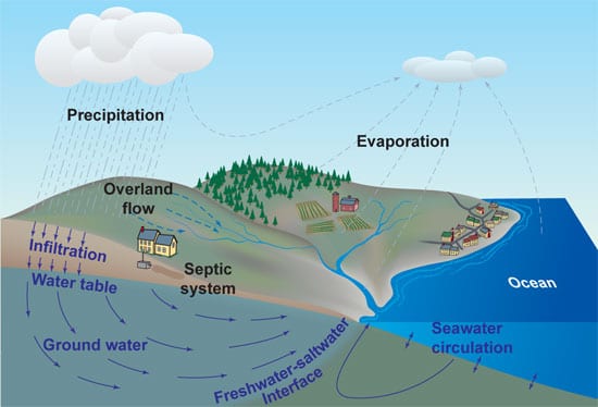
Groundwater discharge appears to be an important factor for determining the chemistry of the coastal ocean. As fresh groundwater flows toward the sea, it rises up over denser, salty water. The fresh and salty water mix along the interface, and the resulting fluid discharges at the shoreline. This interface between underground water masses has recently been described as a “subterranean estuary,” a mixing zone between fresh and salty water analogous to the region where a river meets the ocean. <!– (See Where the Rivers Meet the Sea.) –>
A variety of reactions and transformations both inland and near the coast can influence the amount of dissolved chemicals passing through this underground estuary. Nitrogen, phosphorous, and other contaminants may be introduced into groundwater through a variety of mechanisms. Wastes and nutrients leach from septic systems. Rainfall carries atmospheric pollutants and ground spills down through the soil. Eventually, these chemicals flow underground toward the ocean just as they do in surface tributaries.
Once these dissolved chemicals reach coastal waters, they can influence the abundance of plants and other living species. It is not unusual, for instance, for groundwater to contain dissolved nitrogen in concentrations 100 to 1,000 times greater than in seawater. Nitrogen from human sources, for instance, has led to the over-enrichment (eutrophication) of many coastal bays and waterways. <!– (See Red Tides and Dead Zones.)–>
Under the rocks and stones
Groundwater often flows for long distances and time scales. Unlike surface estuaries, in which water is restricted horizontally by topography—for instance, hills and banks restrict water to channels or streams—groundwater flows throughout Earth’s crust. Soil and subsurface geology play a vital role in influencing the direction and rate at which groundwater flows.
The patterns of submarine groundwater discharge are the result of complex interactions between hydrologic, chemical, geologic, and human influences. A variety of disparate techniques have been developed for accurately assessing and predicting these flows. Unraveling this knot of interwoven influences requires scientists to work across disciplines, bringing chemists together with geologists, hydrologists with mathematical modelers.
For instance, models are useful for investigating and integrating the complexities of the groundwater discharge system, and for predicting the effect of human activities. Models offer idealized mathematical descriptions of how hydrology and underground geology can affect flow. But grounding these models in reality requires a reasonably accurate three-dimensional map of the underground geology.
Such maps require field sampling and the drilling of boreholes into the ground, which can be invasive and expensive. Data from boreholes are high in resolution—scientists can “see” features in the subsurface that are as small as a centimeter—but each hole in the Earth represents a very small sample of sediment at only one location.
Researchers also use geophysical techniques such as ground-penetrating radar, electromagnetic resistivity, and seismic studies, which use the magnetic and sound-propagating properties of rocks and sediments to survey broad areas beneath the surface. Such technological approaches are now less expensive, less invasive of the environment, and more likely to map large areas quickly.
But these tools only provide knowledge of specific physical properties of the underground geology; they do not tell us what types of sediments are below the surface. For that, we must have direct samples (as obtained by drilling) that we can then correlate to the geophysical data.
The best way to map the subterranean environment and its effect on groundwater flow is to combine techniques. By drilling boreholes and conducting geophysical surveys, we can amass enough data to draw realistic maps of the subsurface, which, in turn, make our models more realistic.
Water at the bottom of the ocean
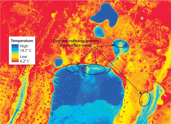
As we develop maps of the underground landscape, we can also gain insight about the groundwater system if we can see precisely where the groundwater is entering the sea, how much is flowing out, and how fast the groundwater is moving. Airborne thermal imaging—which exploits the temperature contrast between groundwater and surface water—is proving to be an especially useful tool for locating groundwater discharge.
On Cape Cod, for example, groundwater maintains a temperature between 10° to 15°C throughout the year; ocean surface water varies from 25°C in summer to 0°C in winter. Through the use of infrared cameras on planes and blimps, we can detect this thermal contrast and see where groundwater is discharging. With this information, we can correlate the groundwater discharge pattern with what we know about hydrologic and geologic features. The combination of observations offers clues about what might be controlling the discharge and provides targets for future sampling locations during fieldwork.
Thermal imagery tells the location of submarine groundwater discharge, but not the rate of the flow. To quantify that, researchers have turned to chemical tracers. The concept is relatively simple: In zones of groundwater discharge, we detect and track a chemical in the groundwater that has a different signature or higher concentration than can be found in surface waters. By knowing the concentration of natural tracers in the groundwater, we can estimate how much fluid is required to account for the excess levels observed in the ocean.
The naturally occurring isotopes of radium and radon in Earth’s crust have proven to be useful indicators of groundwater discharge. Radium and radon are leached from the rocks and sediments that surround and host groundwater aquifers, and they often become concentrated because they are not cycled or decayed as much as they would be in exposed seawater.
Remove the water, carry the water
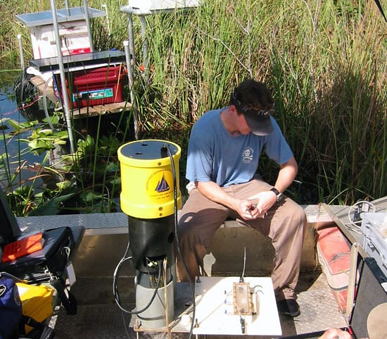
There is an old, well-established mechanical approach to measuring groundwater that has recently been given new life: the seepage meter. First conceived in the 1970s, a seepage meter is essentially the top half of a 55-gallon drum placed over the interface where groundwater seeps out of sediments into the ocean. The seeping groundwater fills a plastic bag connected to the top of the drum, and the amount of fluid captured per unit of time provides an estimate of the flow.
The problem with old-fashioned seepage meters is that they are time- and labor-intensive: If you want to measure flow for 24 hours, you need to sit with your equipment for 24 hours. Longer observations can become tedious, not to mention wasteful when precious research time is spent baby-sitting equipment.
In recent years, we have developed automated seepage meters that allow researchers to track the flow of groundwater continuously for up to a week, even in remote areas. It is now possible to obtain high-resolution, long-term records of submarine groundwater discharge from an unattended, automated meter while we are back in the laboratory working on other parts of the groundwater puzzle. We recently worked with the U.S. Geological Survey to make such measurements as part of their long-term ecosystem rehabilitation program in the Florida Everglades.
Into the blue again
Coastal groundwater-seawater interactions have been studied in many parts of the world, including the southeastern coast of the United States, the Mediterranean Sea, Australia, and Cape Cod. In nearly all of those locations, new lines of evidence suggest that submarine groundwater discharge is an important source of dissolved elements to the ocean. However, few comprehensive geochemical studies of such environments have been undertaken.
That is why we are working together as a groundwater hydrologist and a marine chemist. Through interdisciplinary collaboration, we will be able to see a big picture that can get lost in the details of a limited scientific focus. In the coming years, we are planning work with other WHOI geologists, geophysicists, and chemists to broaden our view of the problem by conducting a comprehensive study of an entire groundwater discharge system from offshore to inland.
To advance our understanding of the importance of groundwater to our coastal environment, we must take an interdisciplinary approach. Proper management of coastal water resources—which are becoming overrun by natural and man-made forms of pollution—requires that we learn more about the quantity and quality of these inputs.
The National Science Foundation, the WHOI Coastal Ocean Institute, the Cove Point Foundation, and the National Oceanic and Atmospheric Administration provide funding for this research.
Slideshow
Slideshow
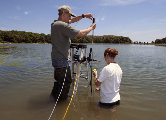
 WHOI Postdoctoral Scholar Kevin Kroeger and Guest Student Kayla Halloran install a well in Eastham, Mass., to sample groundwater seeping into a salt pond. Between 5 and 10 percent of the fresh water in the ocean comes from groundwater seeping through submarine sediments. (Tom Kleindinst, WHOI Graphic Services.)
- WHOI Associate Scientist Matt Charette (left) and Research Assistant Matt Allen use pumps and instruments deployed on a canoe to collect water samples from Pamet Harbor in Truro, Mass. By measuring the amount of dissolved radon and other chemical tracers—leached naturally from rocks or introduced by septic systems—they can measure the flow of submarine groundwater into the coastal ocean. (Tom Kleindinst, WHOI Graphic Services.)
- HYDROLOGIC CYCLE IN COASTAL ZONES—Precipitation either evaporates into the atmosphere, gets taken up by plants, flows into streams, or infiltrates the ground and recharges aquifers. Groundwater flows from inland locations to lakes, streams, or coastal waters. On the seaward side, denser salt water enters sediments and establishes equilibrium with fresh groundwater. Tides and mixing along the freshwater-saltwater interface results in seawater circulation through the sediments.
- COOL VIEW OF GROUNDWATER—Infrared images shot by airplane in September 2002 reveal the extent of groundwater seeping into Waquoit Bay, Mass. Bright yellows indicate locations where cool groundwater is emerging from the sandy bottom into the salty, warm waters of the bay. (SenSyTech, Inc. and Ann Mulligan, WHOI.)
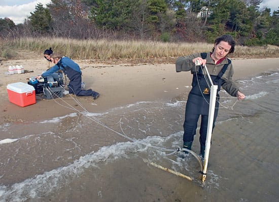
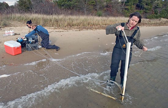
- GO WITH THE FLOW—WHOI Assistant Scientist Ann Mulligan (foreground), Research Assistant Meagan Gonneea (blue shirt), and visiting student Claudette Spiteri collect data about groundwater discharge into Waquoit Bay, Mass. By measuring water pressure, temperature, and conductivity, they can monitor how fast groundwater is flowing and how the interface between fresh water and salt water changes over time. (Tom Kleindinst, WHOI Graphic Services.)
- Research Assistant Matt Allen sits on an airboat and sets up a WHOI-designed automated seepage meter for a three-week deployment in the Florida Everglades. (Matt Charette, WHOI)
Related Articles
Featured Researchers
See Also
- Coastal Groundwater Geochemistry
- USGS Ground Water Information Pages
- Waquoit Bay National Estuarine Research Reserve
- Ground Water in Freshwater-Saltwater Environments of the Atlantic Coast
- National Research Council: Confronting the Nation's Water Problems- The Roles of Research
- USGS Center for Coastal and Watershed Studies
- Magnitude of Submarine Groundwater Discharge and its Influence on Coastal Oceanographic Processes
- Coastal Ocean Institute
- The Groundwater Foundation
- WHOI Marine Policy Center
- Nature: An underground route for the water cycle (PDF, Subscription required)


