To Forecast Rain, Look to the Ocean
Scientists explore compelling new way to predict seasonal rainfall
Ever since humans have existed on Earth, they have looked to the heavens to forecast rain. But more reliable clues may lie in the ocean.
New research by scientists at Woods Hole Oceanographic Institution has found clear links between saltier regions in the North Atlantic Ocean in the spring and increased rainfall during the following summer over areas of Africa and the United States. The discovery offers potential breakthroughs to predict rainfall in regions “where even slight variations in rainfall can be a matter of life or death for millions of people,” said Laifang Li, a WHOI physical oceanographer.
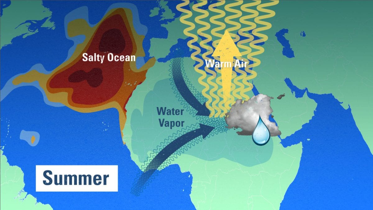
Li and colleagues suggest that saltier-than-normal areas in the ocean indicate places where evaporation has increased—leaving salt behind and putting more fresh water vapor into the atmosphere. The researchers tracked how water that evaporated over ocean regions eventually rained on certain regions on land.
Each year, an estimated 100,000 cubic miles of water evaporates from the ocean’s surface—enough to flood our entire lower 48 states to a depth of 180 feet. About 90 percent of this moisture precipitates right back into the ocean—a vast recycling of moisture that represents the bulk of our planet’s water cycle. But about 10 percent of the evaporated water gets carried over land and precipitates there.
Li and WHOI colleagues Ray Schmitt, Caroline Ummenhofer, and Kris Karnauskas analyzed 60 years of data on rainfall and ocean salinity. Schmitt and colleagues used detailed salinity maps generated by NASA’s Aquarius satellite to identify a patch of the North Atlantic with the highest salt concentrations anywhere in the open ocean.
Li and Schmitt drew a box around the area and explored the central question: Where did all the evaporated fresh water from that area go? They found that it went to the Sahel region in northern Africa. And across the ocean, they found that evaporation that left saltier areas in the western Atlantic and the Gulf of Mexico led to more rainfall in the United States Midwest.
The water isn’t directly or quickly transported from ocean to land, however. Upon closer analysis, they found a more complicated process that creates a three-month lag time.
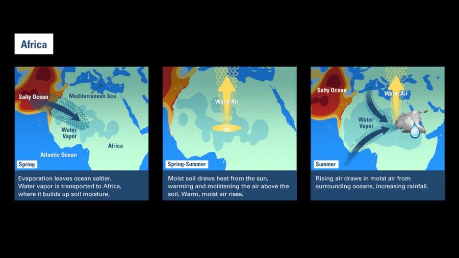
The process works like this: Water vapor evaporated from the ocean is transported through the atmosphere to Africa. It falls as rain, gradually soaking the region’s bone-dry landscape through the spring. The soil moisture draws energy from the sun, which warms the ground and evaporates water into the air above it. Warm, moist air rises like a hot-air balloon. That draws in huge amounts of moisture-laden air from the surrounding Atlantic Ocean and Mediterranean Sea, resulting in heavier rainfall when the summer monsoons hit North Africa.
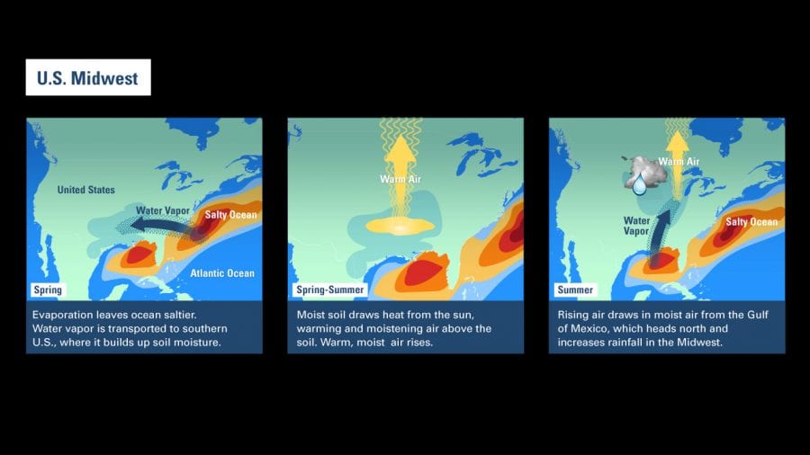
A similar process occurs in the U.S.: Water evaporated from the Atlantic is transported to the southern U.S. in the spring, moistening soil there. Rising warm, humid air eventually draws in more moisture from the Gulf of Mexico. That moist air heads north in the summer, increasing rainfall and sometimes causing flooding in the Midwest.
In 2014, the researchers successfully used their method to predict the Midwest floods of 2015. Then the team extended their technique to the U.S. Southwest. Conventional forecasting methods had predicted above average rainfall for that region during a strong El Niño year. The WHOI ocean salinity-based method, however, predicted low rainfall, which turned out to be the case.
“We see a great deal of potential for applying the same techniques to also improve forecasts in China, India, and other regions,” Schmitt said. “If farmers know it’s going to be a relatively dry year, they may decide to not plant certain crops, plant water stress-resistant crops, or start planting earlier in the year. Water managers would know whether to release more or less water from reservoirs and when to impose water restrictions. And relief agencies could move supplies around based on the amount and timing of droughts or flooding expected during the monsoon season. It could help save millions of lives.”
This research was funded by the National Aeronautics and Space Administration, the National Science Foundation, the WHOI Ocean and Climate Change Institute, and the WHOI Postdoctoral Scholar program. The study was published May 2016 in the journal Science Advances.


