Lakes and Climates Have Their Ups and Downs
A history of water table changes reveals climate shifts and the potential for future drought
Between 5,400 and 3,000 years ago, something happened to New England’s climate. The region became drier. Water levels in lakes dropped. Several droughts persisted for hundreds of years, changing the makeup of local tree and plant populations. Animal and insect populations probably shifted accordingly.
Climate change is not just about temperature change. We don’t know what caused it, but New England’s hydrology—the distribution and circulation of its water—fundamentally changed in the not-so-distant past, and the humid conditions we have come to expect in the northeastern United States were different. Records of past climate conditions give us reason to believe such a change could happen again.
Changes in precipitation
Researchers have looked at pollen grains buried in sediments to seek clues about past vegetation and climate patterns. The types and abundances of different pollens can reveal quite a bit about the average temperatures during a certain period, because some plants thrive and others fade as the Earth warms and cools.
But pollen alone does not necessarily tell us the entire story. My research group is working to demonstrate how the sedimentary patterns within small lakes and ponds can be used to track shifts in moisture over time.
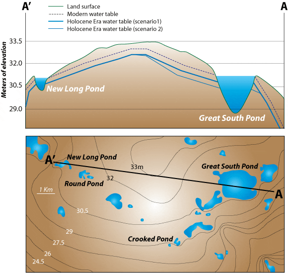
As climate changes—whether on a global or local scale—groundwater tables rise and fall. Some lakes and ponds offer good records of such changes because they are hydrologically “closed”; that is, they are not filled or drained by streams or inlets, but rather their basins are filled with groundwater from below and precipitation from above. As the broad, regional water table fluctuates, these closed water basins rise and fall to different levels in unison.
For instance, during more humid times, a lake might be 20 feet deep and cover a large area. In hotter, drier times—such as a well-documented drought in 1964 in southern New England—the water table lowers; the amount of water in lakes diminishes, their banks lower, and their surface area shrinks. To the rhythm of climate conditions shifting between wet and dry, the sandy shorelines of such lakes migrate in and out, moving closer and farther from the center of the lake.
Warmer winters, lower lakes
My colleagues and I are reconstructing the water-level histories of lakes from Cape Cod to New York over the past 11,000 years, also known as the Holocene Epoch, when the world emerged from the last ice age.
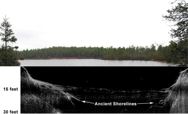
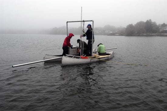
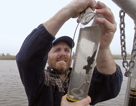
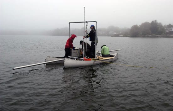
From rowboats and other small vessels, we carry ground-penetrating radar to image lake-bottom sediments. We search for the reflections of the radar pulses made by ancient sandy shorelines lurking beneath organic-rich silts, which subsequently accumulated over the shorelines in more humid times. Once we have found those sand layers, we sink metal coring tubes into the lake bottom to collect plugs of sediment that we analyze and date.
Our studies so far have revealed a drier New England in the past. In the sediments drawn from ponds in Massachusetts and New Hampshire, we have found a common “low stand” from 5,000 to 3,000 years ago, when water levels were much lower and the lakes covered much less area.
Working with Bryan Shuman of the University of Minnesota, we created a simple model of conditions in New England. We suspect that warmer winters (something most New Englanders might idly wish for) may have changed precipitation patterns and ice coverage in the area. With less snow melt to fill lake and pond basins, less ice preventing winter evaporation, and longer growing seasons for plants, the lakes and ponds would have had a much smaller supply of water.
The forecast for droughts
In many ways, the time period we focused on—5,000 to 3,000 years ago—may be one of the best analogs of future conditions in the northeastern U.S. in an era of global warming. The recent National Assessment of the Potential Consequences of Climate Variability and Change states that, in New England, “winter minimum temperatures show the greatest change, with projected increases ranging from 2° to 3º C (4° to 5º F).”
Such warming would decrease snow levels and related groundwater, lake, reservoir, and river recharge. Our reconstructions of the history of hydrologic variability in key temperate regions such as New England offers essential clues for understanding the causes and potential impacts of climate change.
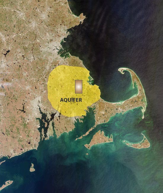
Water availability has a wide range of ecological, economic, and social impacts. It affects vegetation and wildfires. The Massachusetts aquifer that underlies one of our research sites is the second largest in the state and an important water supply for large-scale cranberry production. The lakes we study are about 50 kilometers from the major urban centers of Boston and Providence, which rely on regional reservoirs for water. Water and land managers, farmers, businesses, and civic leaders will need to make informed decisions on how to manage fresh water supplies and mitigate drought.
If drought is coming to the Northeast, we need to look back at Earth’s history and appreciate that a changing global climate could mean drought that lasts not years, but centuries.
The research was supported by the National Science Foundation, and the Ocean and Climate Insitute and the Coastal Ocean Institute at WHOI.
Slideshow
Slideshow
- Jeff Donnelly and colleagues have studied lakes and ponds overlying a large aquifer (yellow) in southeastern Massachusetts to reconstruct the history of past water table and pond levels. The research provides clues to past climate conditions and the potential for future climate change in the region. The brown box within the aquifer represents the area in the illustration below. (Courtesy of Jeff Donnelly, Woods Hole Oceanographic Institution)
- An enlarged view of the brown box in the map above, showing several ponds studied by WHOI scientists. At top, a cross-section (from points A' to A) of the area, showing water table levels today and two scenarios for water table levels 3,000 and 5,000 years ago during the Holocene Epoch when drought conditions prevailed in the New England region. (Courtesy of Jeff Donnelly, Woods Hole Oceanographic Institution)
- An image from a ground-penetrating radar (GPR) is juxtaposed below a photo of the lake surface. The GPR image reveals a sandy ancient shoreline below layers of organic silt that subsequently accumulated on top of it when the lake level rose. The buried shoreline was created when the climate was drier and lake level was lower. (Jeff Donnelly, Woods Hole Oceanographic Institution)
- Donnelly and colleagues sink metal coring tubes into lake bottoms to collect plugs of sediment that are analyzed and dated to reconstruct a record of past climate conditions. (Tom Kleindinst, Woods Hole Oceanographic Institution)
- Donnelly retrieves a core taken from the bottom of Oyster Pond in Woods Hole, Mass. (Photo by Tom Kleindinst, Woods Hole Oceanographic Institution)
Related Articles
- Paddling an angry, ancient ocean
- Reconstructing the Bering Sea’s stormy past
- Coral time machines
- Secrets in the dust
- How historic hurricanes can help predict storm intensity
- Unearthing Long-Gone Hurricanes
- Will Oxygen in the Ocean Continue to Decline?
- Blue Holes and Hurricanes
- More Floods & Higher Sea Levels

