‘High-octane’ hurricane fuel swirls in the Gulf of Mexico
Researchers deploy an arsenal of underwater floats to monitor the Loop Current—one of the Atlantic Ocean’s fastest and warmest currents—to collect critical data for hurricane forecasting.
Estimated reading time: 4 minutes
 This article printed in Oceanus Fall 2020
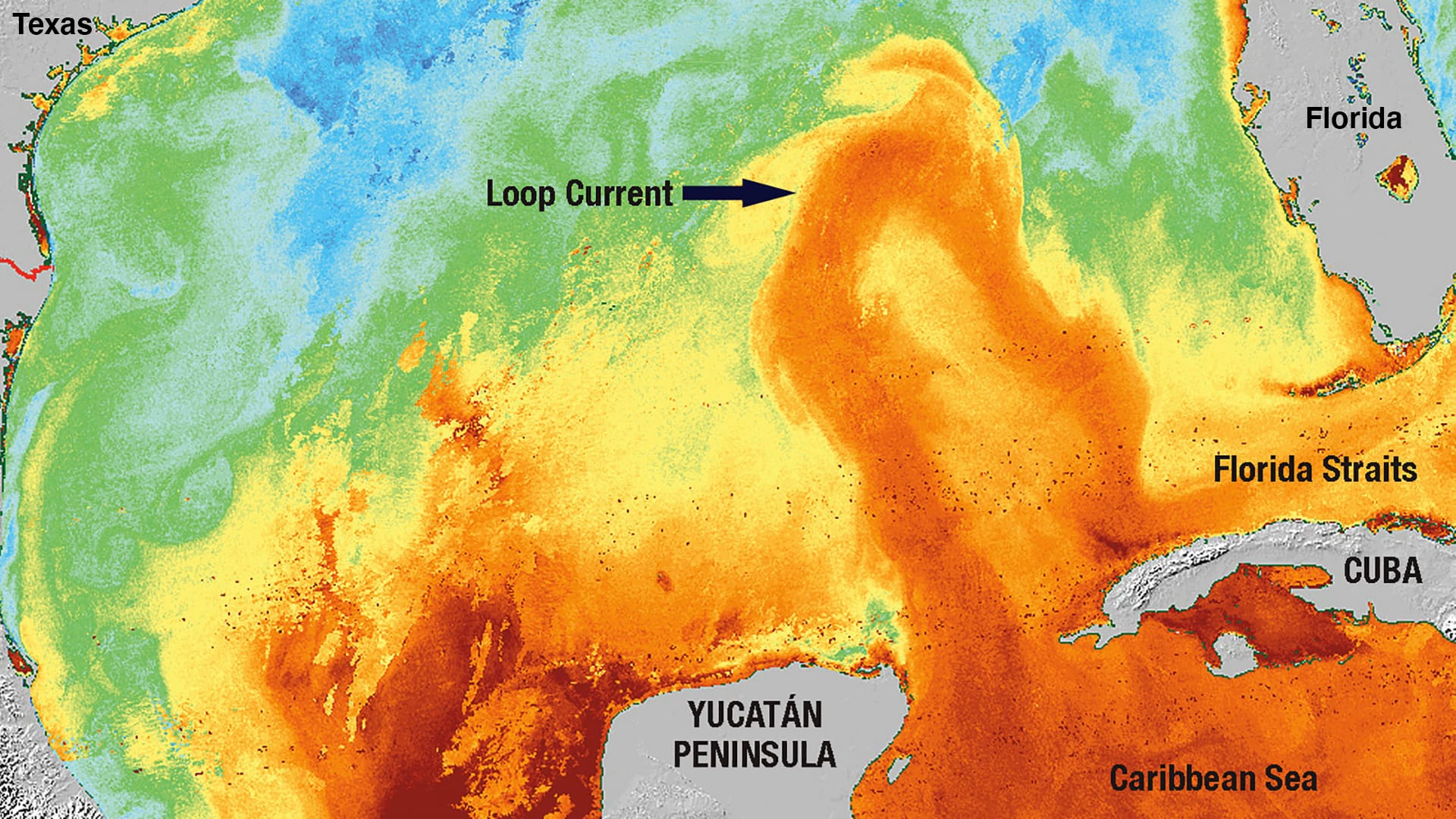
An already warm Gulf of Mexico will once again be heating up this summer thanks to one of the Atlantic Ocean's fastest and warmest currents-the Loop Current-which carries warm water from the Caribbean Sea up past the western tip of Cuba and into the Gulf. There, huge swirling rings of deep warm water the size of Maine will break off from the primary current and wander westward through the Gulf, providing a potent heat source that could cause hurricanes travelling overhead to rapidly intensify.
"I've heard these ring-shaped eddies-and the Loop Current from which they detach-described as 'high-octane fuel' for hurricanes," says Heather Furey, a research specialist at WHOI. "Where the rings are in relation to the path of a hurricane can have a significant effect on the storm's intensity."
Hurricane Rita in 2005 is a case in point. Before slamming into the Gulf Coast that year, the storm passed directly over one of the Loop Current's eddies, which caused it to explode into a monster Category 5 hurricane before making landfall.
Furey, along with WHOI physical oceanographers Amy Bower, Steve Jayne, and Pelle Robbins, and researchers from the University of Rhode Island and the Center for Scientific Research and Higher Education at Ensenada, have recently begun monitoring the Loop Current in order to measure its location and heat content, and provide the data in near real time to hurricane forecasters.
The team has deployed more than 20 underwater instruments in the Gulf-known as Argo floats-that record temperature and salinity as they autonomously travel from the ocean's surface to a depth of 2,000 meters and back up again. These instruments join an arsenal of monitoring tools used by WHOI researchers to track seasonal Atlantic hurricane activity, including underwater gliders that measure the Gulf Stream, sensor-equipped moorings that profile ocean conditions around the clock, and ALAMO (Air-Launched Autonomous Micro-Observer) floats that are dropped into the ocean from U.S. Air Force "Hurricane Hunter" planes flying through hurricanes.
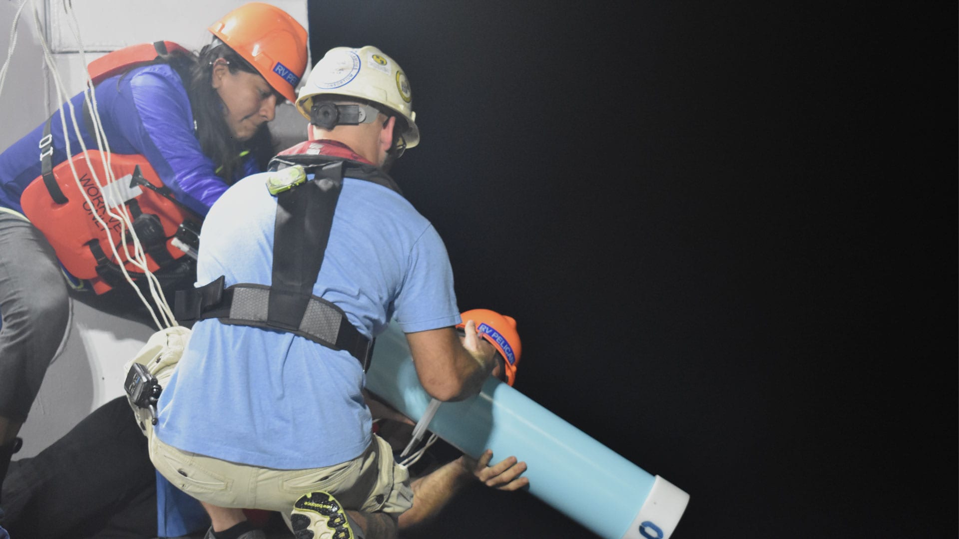
Researchers launch a profiling Argo float over the fantail of the R/V Pelican into the Gulf of Mexico. (Photograph used with permission from the Grupo de Investigación con Observaciones Lagrangianas at CICESE).
Every five days, the Argo floats, which look like human-sized medical syringes, surface and transmit the measurement data back to shore where they're automatically fed into ocean models forecasters use to predict storm strength.
Furey says Argo floats are key since they track heat content all the way down the water column, unlike satellites, which are only able to take measurements at the ocean's surface. The deeper the heat goes; the more fuel hurricanes will have as they pass over the Loop Current and its eddies. Hurricane models cannot predict the true strength of a hurricane without knowing the properties of the water under the ocean surface.
Ocean heat isn't the only concern, however. Salt also plays a role.
"The floats are also measuring the salinity gradient of the water, since low salinity water at the sea surface can act as a lid that caps a hurricane from drawing more heat from the ocean," says Furey. "Increased salinity gradient will dampen a storm's strength."
This "empty sea" animation shows the flow of warm water through the Yucatan Peninsula and Florida Straits into the Gulf Stream, and a ring-shaped eddy detaching from the main Loop Current. (Animation by WHOI Creative Studio © Woods Hole Oceanographic Institution)
Bower says one of the reasons Argo floats were chosen for the project is their relative affordability.
"The Argo floats were the right balance between science objectives and cost," says Bower. "You could populate the eastern Gulf with profiling moorings, but that could cost tens of millions of dollars."
The set-it-and-forget-it design of the floats means that, in theory, they can perform their missions with little human intervention once deployed. But if need be, the scientists can take the driver's seat and control the floats remotely by sending them new commands over cellular networks.
"We can reprogram floats to speed up their measurement sample rates when a hurricane comes through, or move up or down in the water column in order to try to keep the float in the eastern Gulf where we want to measure the ocean under a hurricane," says Furey. "Just like the floats can send data to us, we can send data back to them."
Moving forward, the researchers are trying to secure funding for four additional floats in the eastern Gulf this year to broaden the coverage. In addition to helping forecasters better predict storm intensity this year, the team is hoping to use the float data to better understand the dynamics at play in eddy formation.
"We don't have a good understanding of why eddy rings break off from the Loop Current in the first place," says Bower, "so we're hoping the floats give us more insight."
This research is funded by the National Academy of Sciences Gulf Research Program.

