Pakistan’s ‘Ocean of Water’
WHOI’s Caroline Ummenhofer discusses how interactions between the Pacific and Indian Oceans influenced Pakistan’s devastating monsoon rains
Estimated reading time: 4 minutes
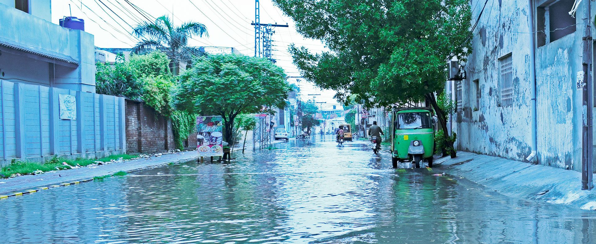
The South Asian monsoon brings much-needed rain to the Indian subcontinent each summer. The monsoon typically lasts from mid-June to September. Timing-wise, this year was no different. But the sheer volume of rain that fell, particularly in southern Pakistan, is unlike any in recorded history. More than a month after the rains stopped, the country faces a years-long recovery. More than 1,500 people have died, along with an estimated 750,000 head of livestock. Tens of thousands of square kilometers of cropland have been destroyed, thousands of people are injured, and the stagnant waters are causing disease. Pakistan officials have referred to the nationwide flooding as an 'ocean of water.'
Where waters have receded, villages and surrounding agricultural lands have been covered in layers of sediment. Those are the lucky ones. Flooding of the Indus River created an inland lake 100 km (62 miles) across. Many villages remain submerged. The fortunate few dot the watery landscape, reduced to islands with no connection to what is now the “mainland.”
“A warmer atmosphere over a warmer ocean is going to take up more moisture.”
—Caroline Ummenhofer
It’s a tragedy of epic proportions, and one that appears to be driven, at least in part, by warming global temperatures. “Evaporation over the oceans typically happens once [water temperatures] hit 28° Celsius,” says WHOI physical oceanographer Caroline Ummenhofer. “The warmer water is, the more moisture that is going to evaporate. A warmer atmosphere over a warmer ocean is going to take up more moisture.”
Warmer land temperatures also play a role. Heat causes air to rise, creating a vacuum near the ground that draws in masses of air from surrounding areas. This pulls the water-laden air in from the ocean, creating monsoons that can last for months.
Knowing when and for how long these rains will fall is essential to helping people prepare, but it’s tricky business, trying to model something as complicated as monsoon rains. They are an atmospheric phenomenon driven by a complex interplay between land, water, and air. Large ocean-atmosphere systems, such as the El Niño Southern Oscillation (ENSO) affect the Asian monsoons. ENSO shifts warm waters across the Pacific Ocean. During an El Niño year, easterly trade winds weaken or reverse, which allows warm water to move eastward, greatly increasing surface ocean temperatures in the central and eastern Pacific. In La Niña years, the trade winds strengthen, enhancing accumulation of warm waters in the western Pacific. It’s these La Niña years that coincide with extreme monsoonal flooding events, and this year was no different.

But the drivers behind the monsoon are more complicated than La Niña. The Indian Ocean has an equivalent ocean-atmosphere system. “It’s the interplay between what’s happening in the Pacific, what’s happening in the Indian Ocean, and how those two oceans interact and affect the overlying atmosphere and affect the wind system that really will affect the Indian monsoon,” Ummenhofer explains. “There are a lot of factors that play into that.”
The Indian monsoon typically brings rain from the Arabian Sea situated to the west of the subcontinent. This year, weather systems tracked from east to west, originating instead in the Bay of Bengal. Heating of the Indian subcontinent may have played a role. Pakistan experienced record-high temperatures in the months before the monsoon. Such heat creates low-pressure areas near the surface that draw in weather systems. This year, eight separate systems pummeled the subcontinent, crossing India to reach Pakistan, where they collectively dumped up to eight times the typical amount of rain.
Rains across the subcontinent declined from the 1950s to the 1980s, driven by warmer waters and cooler land temperatures over India. Temperatures cooled due to pollution from sulfate aerosols, which increased cloud cover. Since the 1980s, however, monsoon rains have gotten both more variable from year to year and, when they do fall, up to 75% more intense.
A 2021 study by the Potsdam Institute for Climate Impact Research used more than 30 models from around the world to analyze these changes. They found strong evidence that monsoon rains are more intense than they would have been without the 1.2° Celsius (2.7° Fahrenheit) warming we have experienced since the beginning of the Industrial Revolution. All but four models project that future monsoon rains will become more variable as Earth continues to warm. And the models project that for every degree Celsius of warming, rainfall will increase by 5 percent, with an increase in the number of wet years and more high-rainfall events.
“Extreme rainfall events are likely to become more extreme in a warming climate,” Ummenhofer notes. “I think that is consistent with our expectation and what is happening in a warmer world. That is obviously playing out here.”

MEET THE AUTHOR Alison Pearce Stevens
Alison Pearce Stevens, Ph.D. is an award-winning writer dedicated to making science accessible to audiences of all ages. She writes for the Woods Hole Oceanographic...
Read more