For Sharks, the Nose Knows
... and other research news by WHOI scientists
For Sharks, the Nose Knows
Sharks follow their noses to zero in on prey—but only one nostril at a time. When sharks catch a whiff of a potential meal, timing is everything: They will head in the direction of the nostril that caught the scent first—even when the other nostril detects higher concentrations of the odor.
A new study by Jayne Gardiner of the University of South Florida and Jelle Atema of Boston University and the Woods Hole Oceanographic Institution refutes the prevailing theory that sharks follow the strongest scent when hunting prey. Timing can be a much more reliable tool than odor strength, Atema explained, because odors do not travel in coherent plumes in the ocean. “The plume breaks up into pieces, floats to different levels and gets transported in a current,” he said.
Most often, sharks will hit an odor patch at an angle rather than straight on. By veering in the direction of the nostril that first encounters the odor, the shark will automatically steer into the odor patch. The difference in timing between when each nostril catches a scent can be as small as a tenth of a second.
The research team performed the sensory experiments on smooth dogfish sharks (Mustelus canis), a small species fairly common in waters off New England. Researchers used specialized headgear with tubes that fed small puffs of squid odor into the sharks’ left and right nostrils. Their study was published in the July 13, 2010, issue of the journal Current Biology.
Smell is only one of several keenly attuned senses that make sharks efficient predators. In an earlier study, Gardiner and Atema found that sharks use what Atema described as a “fantastically sensitive organ” called a lateral line, which runs the length of their bodies and picks up vibrations in the water.
“It functions similar to the hairs on our skin, except that it’s much more sensitive,” Atema explained. “They measure minuscule water flow differences in the environment.”
Sharks use their sense of smell to steer toward a patch of odor. Then they use information from their lateral lines about water flow to track odor patches expediently to their source.
“Inspired by odor, sharks also look for current,” Atema said. “The two together is what makes them so efficient.”
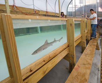
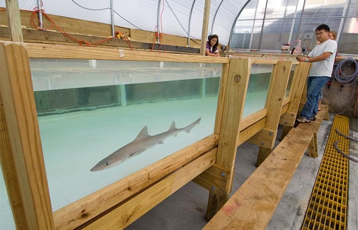
IMAGE CAPTION: A smooth dogfish swims in a testing tank in the WHOI Environmental Systems Lab, where researchers are working to learn how sharks use their senses to locate food. (Photo by Tom Kleindinst, Wood Hole Oceanographic Institution)
—Erin Koenig
The National Science Foundation funded this research.
How Deep is the Ocean?
How much do I love you?
I’ll tell you no lie
How deep is the ocean?
How high is the sky?
—Irving Berlin
Scientists have a pretty good handle on how high the sky is. But they’ve had more trouble nailing the second part of Berlin’s classic song.
Until now, a Google search to find out how deep the ocean is would have given you five different numbers, most of them 30 or 40 years old, said Matthew Charette, a marine chemist at Woods Hole Oceanographic Institution.
Reporting in the June 2010 issue of the journal Oceanography, Charette and Walter H.F. Smith, a geophysicist at the National Oceanic and Atmospheric Administration, calculated more precise numbers for the ocean’s depth and volume. Using satellite measurements, the researchers said that the world’s total ocean volume is 1.332 billion cubic kilometers—about 0.3 percent lower than the estimates of 30 years ago. That might not seem like a lot, but it’s equivalent to about five times the water in the Gulf of Mexico, or 500 times the Great Lakes.
Satellites made the scientists’ calculations more accurate by helping them more precisely locate undersea mountain ranges and other seafloor formations, which take up space that would otherwise be occupied by water. Satellites don’t reveal the seafloor directly; they measure the ocean’s surface, which bulges outward when it lies above a seafloor mountain.
It’s interesting to note, Charette said, how accurate scientists were in the past, using cruder techniques. In 1888, John Murray dangled lead weights off a ship with a rope to find the ocean’s mean depth. He then multiplied the ocean’s depth by its area to calculate the ocean’s volume. His number was just 1.2 percent greater than Charette’s and Smith’s figure.
For those of you wondering, someone singing Berlin’s song to you today wouldn’t love you as much as he or she did 30 years ago. The new study’s calculation of the ocean’s mean depth is 3,682.2 meters—21 to 51 meters less than previous estimates.
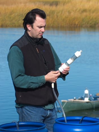
IMAGE CAPTION: WHOI marine geochemist Matthew Charette took a detour from his usual research on groundwater to help make new calculations of the ocean’s depth and volume. (Photo by Tom Kleindinst, Woods Hole Oceanographic Institution).
—Joel Greenberg
This research was funded in part by the EarthWater Institute.
WHOI team revisits Titanic wreck site …
Twenty-five years after a WHOI-French expedition discovered the wreckage of RMS Titanic, WHOI scientists returned to the site with advanced technology to create the first marine archeology base map of the Titanic wreck site.
Researchers operated two WHOI-built REMUS autonomous underwater vehicles, owned by the Waitt Institute, with advanced acoustic imaging and electronic still cameras. The WHOI Advanced Imaging and Visualization Lab supplied 2-D and 3-D high-definition cameras used on a remotely operated vehicle.
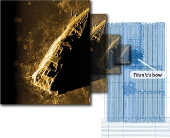
Under unusually strong and opposing currents and with two hurricanes passing through, the team mapped a 5-by-3-mile area of North Atlantic seafloor in medium resolution and a 1-by-1.5-mile area (near left) with high-resolution sonar and still photos. Combined, they collected more than 300 terabytes of data.
The WHOI team worked with Premier Exhibitions Inc., NOAA, the National Park Service Marine Archeology Division, the Institute for Marine Archeology, and Phoenix International to study the ongoing deterioration of Titanic, create a marine archeological base map for the wreck site, and help establish a model for managing and preserving shipwrecks in deep water.
IMAGE CAPTION: Using advanced sonar and acoustic imaging technology and 3-D high-definition cameras, WHOI researchers created a map of the Titanic wreck site and collected new images of the shipwreck (above left). Blue lines (above right) show the tracks of two autonomous underwater vehicles that swam over the seafloor, mapping a 1-by-1.5-mile area of the wreck site. (Images courtesy of Premier Exhibitions Inc.)
…and aids search for wreck of crashed Air France plane
At the request of the Bureau d’Enquêtes et d’Analyses, the French equivalent of the U.S. National Transportation and Safety Board, WHOI researchers took part in an international sea search operation in the spring of 2010 to look for the deep-sea wreck site of Air France Flight 447 and to retrieve the airplane’s flight recorders. The Airbus A330-200 crashed inexplicably over the South Atlantic Ocean on June 1, 2009, while traveling in heavy thunderstorms from Rio de Janeiro to Paris. All 228 passengers and crew were killed. Two months of surveying with REMUS 6000 underwater vehicles, provided by the Waitt Institute and the University of Kiel in Germany, did not produce any trace of wreckage in the rugged seafloor terrain where the airplane went down. WHOI researchers will be aboard a new expedition to continue the search, scheduled to begin in February 2011.
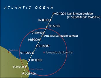
IMAGE CAPTION: Map shows the approximate flight path of the ill-fated Air France Flight 447.

