Discovery of “Megamullions” Reveals Gateways Into the Ocean Crust and Upper Mantle
urposes. From the end of the nineteenth into the first half of the twentieth century, drilling was used to penetrate the reef and uppermost volcanic foundation of several oceanic islands, and these glimpses of oceanic geology whetted the scientific community’s appetite for deeper and more complete data.
Spring 1998 — Long before the plate-tectonic revolution began in the 1960s, scientists envisioned drilling into the ocean crust to investigate Earth’s evolution. As early as 1881, Darwin suggested drilling Pacific atolls for scientific purposes. From the end of the nineteenth into the first half of the twentieth century, drilling was used to penetrate the reef and uppermost volcanic foundation of several oceanic islands, and these glimpses of oceanic geology whetted the scientific community’s appetite for deeper and more complete data.
The idea of ocean drilling gained momentum in the 1950s and resulted in the “Mohole project,” whose objective was to sample the material beneath the Mohorovicic discontinuity, or “Moho,” the boundary between Earth’s crust and mantle. The Mohole project proved to be ahead of its time, but the program’s test drilling in the deep eastern Pacific Ocean proved that ocean crust could be successfully drilled and cored from a dynamically positioned ship in several thousand meters of water. Mohole was succeeded beginning in the late 1960s by the hugely successful Deep Sea Drilling Project, the International Phase of Ocean Drilling, and the current Ocean Drilling Program. (For “An Abridged History of Deep Ocean Drilling” by Arthur E. Maxwell, see Oceanus Vol. 36, No. 4.)
A major scientific goal of all these efforts has been to recover a complete section of normal ocean crust and uppermost mantle. The lithology, properties, and geological relations of these rocks are key to understanding such varied phenomena as convection in the earth’s mantle, melting and transport mechanisms in the upwelling asthenosphere beneath mid-ocean ridges, rock deformation and alteration, the sources of magnetic anomalies in ocean basins, and hydrothermal circulation and formation of ore deposits.
Poking at the Oceanic Lithosphere
The outstanding obstacle to drilling through the entire ocean crust is that normal crustal thickness is on the order of 6 to 7 kilometers. Penetrating it beneath several thousand meters of water is presently at the limits of drilling technology as well as beyond the financial boundaries of scientific funding. Currently, drilling to depths of 1.5 to 2 kilometers has yielded upper ocean crust samples, as well as sections of deeper crust and upper mantle where these rocks are exposed by natural tectonic processes. Pieced together, these sections are in many ways similar to our conception of what ocean crust should look like, based on studies of ophiolites, old seafloor parcels that have been exposed above sea level by various tectonic mechanisms. (See map in Peter Kelemen article.)
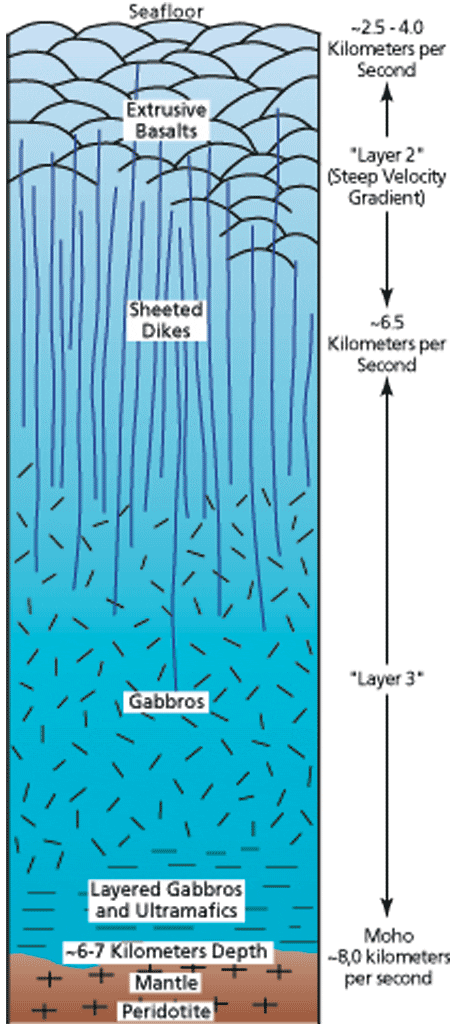
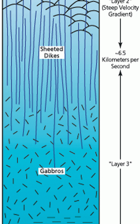
At its base, the “standard ophiolite model” (see top figure) includes an “ultramafic” layer (made up of dense rock rich in iron and magnesium) that represents the oceanic mantle. The overlying crust is formed from melt that rose buoyantly at a mid-ocean ridge from the hot, upwelling mantle. From bottom to top, the crust consists of layers formed by crystallization in presumed magma chambers or zones of hot crystal mush, a shallower section of vertically oriented, intrusive dikes,* and a volcanic surface layer of pillow basalts extruded onto the seafloor and capped by sediments. Laboratory analyses show that each of these sequences transmits sound waves with characteristic velocities, and seismologists studying sound propagation in the deep ocean basins have roughly equated observed crustal velocity layering with rock type in the standard ophiolite model. From mapping of seismic velocities, the subseafloor depth of the top of the mantle (the Moho), and thus the apparent thickness of normal ocean crust, appears to be remarkably uniform at about 6 to 7 kilometers.
However, there are several problems with relying too heavily on the ophiolite and velocity models. First, while ophiolites offer the convenience of being able to walk the outcrop and directly study geological relationships, there is considerable debate as to their value for interpreting the structure of normal ocean crust. Many ophiolites are known to have originated in unusual tectonic settings such as behind island arcs or above subduction zones, and it is uncertain how representative they are of crust beneath most large ocean basins. Second, it is likely that the standard ophiolite model is overly simplistic. Spreading rates and the associated levels and constancy of magma production vary dramatically among mid-ocean ridges, so the magmatic and tectonic structure of deep ocean crust probably seldom approaches the ideal model, particularly where magma supply is limited. Finally, our suppositions about the relative uniformity of crustal thickness and composition, as inferred from velocity-lithology correlations, could be seriously in error. In particular, normally high-velocity ultramafics of the upper mantle may become altered by seawater that penetrates deeply along faults and fractures. Such alteration can dramatically reduce sound velocity in these rocks, making them appear seismically to be part of the ocean crust and thus causing us to overestimate true crustal thickness.
To resolve such uncertainties, we are still faced with the need systematically to sample the entire crustal and uppermost mantle sequence within the ocean basins. To date, the best path to this goal has been to sample local tectonic exposures, but because of the intermittency and incompleteness of outcrops, this has been considered a piecemeal solution at best. Recent discoveries, however, indicate that complete, naturally occurring crust-mantle cross sections may be exposed on the seafloor by unusually long-lived faults. These sections have the potential to yield long-sought answers to questions about the structure and origin of oceanic crust.
Nature Opens the Door
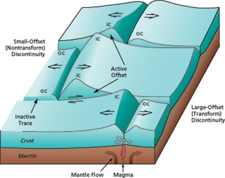
To understand how tectonism exposes cross sections of the ocean crust, we must first consider the typical along- and across-axis structure of mid-ocean ridge (see second figure from top). The spreading axis, where magma wells up to form new ocean crust, is offset by discontinuities to form numerous individual spreading segments that extend from a few tens of kilometers to more than a hundred kilometers along the ridge axis. At the axes of slow-spreading ridges (where total spreading rate is less than about 35 to 40 millimeters per year), seismic studies of spreading segments, together with gravity studies of density distribution and direct seafloor sampling by dredging and submersible, indicate that crustal thickness is greatest near segment centers and that it thins markedly toward the discontinuities at segment ends. From this, we infer that upwelling of magma from the mantle is relatively focused near the centers of slow-spreading segments. At faster-spreading ridges, in contrast, crustal thickness tends to be more uniform along the length of spreading segments, and upwelling of magma therefore appears to be more evenly distributed along a segment.
Another significant difference between slow- and fast-spreading ridges is in magma supply. The rate of magma supply at slow-spreading ridges is relatively low compared to the rate of axial crust extension, while the rates are more comparable at fast-spreading ridges. The result is that tectonic extension, expressed in the form of large normal faults, is much more profound at slow-spreading ridges, particularly at segment ends. These faults cut deeply into and sometimes through the ocean crust. If extension occurs for a long enough period on a fault, then a significant portion of the ocean crustal section, and possibly even upper-mantle rocks, could be exhumed along the fault plane. Do these geological cross sections actually exist on the seafloor, and, if so, under what conditions are they formed?
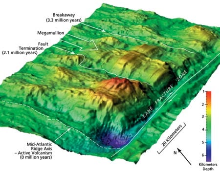
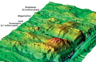
Recent discoveries suggest an affirmative answer to the first question. In 1996, both British and US expeditions to the slow-spreading Mid-Atlantic Ridge found remarkable seafloor edifices, each of which appears to have originated by long-lived slip on an individual normal fault. These features, which we term “megamullions,” have two distinctive characteristics: first, a domelike or turtleback shape extending over a diameter of some 15 to 30 kilometers, and second, conspicuous grooves or corrugations (mullions) that formed as part of the faulting process and that parallel the direction of fault slip over the domed surface. (See third figure from top.) We have interpreted the mega-mullions as footwall blocks, that is, blocks exhumed from beneath normal faults. (See figure above right.) In the case of megamullions, these faults have been unusually long-lived and areally extensive, and we refer to them as “detachment faults.” Once megamullions were recognized, our subsequent study of existing, detailed multibeam bathymetric data has identified a total of 17 of these features between about 21° N and 31° N on the Mid-Atlantic Ridge, and a number of other megamullions have been recognized where strong tectonic extension occurs on slow- to intermediate-spreading mid-ocean ridges in the Indian Ocean.
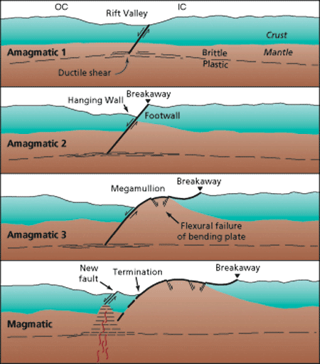
Each detachment fault that forms a mega-mullion has three notable features: a breakaway zone where the fault began, the exposed fault surface that rides over the megamullion dome, and a termination, which usually is marked by a valley and adjacent ridge. By identifying breakaway and termination ages from dated seafloor magnetic anomalies, we can establish that the faults forming the North Atlantic megamullions accommodated slip for periods between 1.0 and 2.6 million years, with an average period of 1.5 million years. The original dip of the faults is uncertain, but they probably dipped at up to about 45°, much like most seismically active normal faults presently observed at the axes of mid-ocean ridges. With this dip, the faults would have exhumed a full 6-kilometer-thick crust and even exposed the underlying mantle within less than a million years. As these rocks are drawn out from beneath the fault, the footwall “rolls over,” laying out the geological cross-section across the surface of the megamullion. The rollover also flexes the brittle footwall much like bending a wooden ruler—the upper part of the footwall block is under tension and new normal faults break through the detachment surface.
Under what conditions do these long-lived faults develop? In terms of their position on the seafloor, all megamullions identified thus far appear near segment ends at inside-corner (IC) locations (that is, within the bights between the actively slipping sections of ridge-axis discontinuities and the spreading axis). Geophysical data and recovered rock samples show that ocean crust at inside corners of slow-spreading ridges is intermittently thin or missing compared to relatively normal thickness, outside-corner (OC) crust on the opposite side of the spreading axis. This seems to be best explained by consistent orientation of faults dipping from inside corners toward outside corners; in this way the upper crust (hanging wall) is frequently stripped from the inside-corner footwall. However, this process cannot be continuously occurring on a single fault. If it were, all inside corners would exhibit megamullions (but only a small percentage do), and they would almost exclusively expose mantle rocks (which they do not). Rather, it appears that a single fault is normally active for only a short period of time (a few tens to hundreds of thousand of years) before it is abandoned and replaced by a new fault closer to the spreading axis.
What, then, promotes slip on a single fault for periods of up to 2 million years or more? And what eventually causes the fault to be abandoned? Clearly, for a fault to remain active it must be weak in comparison to adjacent crust where another fault might otherwise nucleate. Recent laboratory studies have demonstrated changes in deformation mechanism at sub-seafloor depths where faults in the brittle lithosphere flatten out into zones of plastic deformation in hotter, deeper rocks. These changes weaken the rock by a factor of ten or more compared to surrounding, unfaulted rocks, and they thus promote slip in the shear zone. Slip probably is also enhanced by the occurrence of weak serpentinites along faults at shallower levels within the brittle litho-sphere. Serpentinites form as sea-water percolates down fractures and reacts with ultramafic rocks in the lower crust and upper mantle at temperatures ranging from about 100° to 500°C.
These kinds of weakening, however, are not the entire answer to the question of fault longevity because they probably occur on many (if not most) faults in slow-spreading crust, whereas truly long-lived faults are few and far between. A more complete explanation can be devised if we consider the temporal variability of magmatism at the spreading axis. Episodes of magmatism are known to occur at time scales of tens to hundreds of thousands of years at slow-spreading ridges, and recent analysis of gravity data over ridge flanks also indicates a predominant cycle at a period of two to three million years. Megamullions consistently correlate with the parts of these longer cycles where the gravity data indicate the presence of thin crust and predominantly amagmatic extension. Thus, it appears that persistent slip on a fault occurs while the spreading axis is relatively cold, but that when magmatism is renewed, it heats and weakens the lithosphere, new faults form, and the long-lived fault is abandoned. The relative rarity and the locations of megamullions suggest that completely amagmatic extension is not common even in slow-spreading crust, and when it occurs it is restricted mostly to segment ends near ridge-axis discontinuities.
Windows of Opportunity
The cross sections through the crust and into the upper mantle that appear to be laid out across the surface of megamullions offer exciting new windows of opportunity finally to sample the oceanic lithosphere in detail. Marine geologists are now proposing to drill a series of half- to one-kilometer-deep holes, aligned in the direction of fault slip across the surfaces of megamullions. From these cores, we should be able to construct a composite, but relatively complete, picture of the entire crust-mantle section, without ever having to drill the 6 kilometers or more that would be required to reach the mantle beneath normal-thickness ocean crust.
There is, however, much to be done before the drilling occurs. A few samples have been obtained from megamullions, and as expected they include lower-crustal and upper-mantle rocks. Nonetheless, most of our interpretations are based on remotely sensed data such as gravity and bathymetry, together with models of the faulting process. Detailed surveys and sampling with deep-towed instruments and submersibles like Alvin are needed fully to document the geology of the outcrops and to select optimum locations for drilling. This mapping and sampling will also provide critical information for correlating data between drill holes and to understand the three-dimensional internal structure of the crust and mantle.
In addition to providing lithospheric cross sections, megamullions have the potential to yield significant insights into other outstanding geological problems. For example, it has long been thought that the primary source of marine magnetic anomalies lies in the upper, extrusive section of the oceanic crust. Yet, at megamullions, where this layer is thought to be missing, perfectly normal magnetic anomalies usually are developed. Either we are grossly mistaken in our interpretation of these features, or else the lower part of the ocean crust contains a substantial magnetic signature. Near-seafloor magnetic studies and laboratory analyses of magnetization in recovered rock samples will resolve this question.
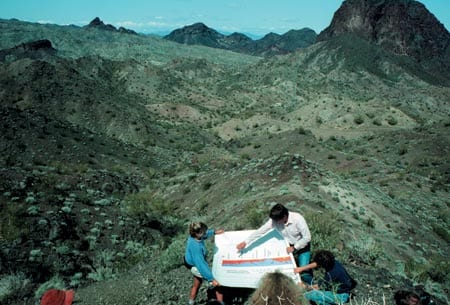
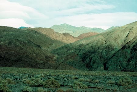
Although the focus here has been on oceanic lithosphere, we also can benefit from and contribute to the study of tectonics in continental crust (see two photos above). Megamullions have dimensions, shape, and an apparent mode of origin via long-lived detachment faulting that are very similar to those of “metamorphic core complexes” exposed in extensional mountain belts such as those found in the southwestern United States. In these areas, domed core complexes have exhumed rocks from some 15 kilometers deep in the continental crust, and their structure and deformation history have been studied extensively for more than two decades. Cross-pollination of insights gained from both the continental and oceanic realms will allow us to develop a much more comprehensive understanding of extensional tectonism and the intriguing exposures of deep lithosphere both on land and in the ocean basins.
This mid-ocean ridge research has been supported by the National Science Foundation, the Office of Naval Research, and WHOI’s Andrew W. Mellon Foundation Endowed Fund for Innovative Research. The author is indebted to colleagues Jian Lin, Marty Kleinrock (Vanderbilt University), Greg Hirth, Henry Dick, and Joe Cann (University of Leeds, UK) for stimulating discussions about tectonism in slow-spreading crust, and to Eric Frost (San Diego State University) and Kip Hodges (MIT) for superb field exposition of extensional tectonics in the Basin and Range.
Born and raised in the natural geological laboratory known as the Black Hills of South Dakota, Brian Tucholke has been a geologist from the time he first crawled off his baby blanket and grabbed a fistful of dirt. As one of the Ph.D. students entering the MIT/WHOI Joint Program in its inaugural year, he (mostly) gave up the bedrock stability of the western mountains for the rolling sea, and he has since been on more than 25 oceanographic research cruises to investigate the flow of abyssal currents, seafloor sedimentation patterns, the paleoceanographic history of ocean basins, the structure and evolution of continental margins, and the tectonics of mid-ocean ridges. The mark of his passage can often be seen in the imprint of his cowboy boots, several decrepit pairs of which he has buried at sea in oceans ranging from the North Atlantic to the Bellingshausen Sea off Antarctica.
Slideshow
Slideshow
- Schematic section through oceanic crust, based on study of subaerially exposed ophiolites and drilling results in the ocean basins. Boundaries between lithologic units are usually transitional and complex, and units may be thin or missing where magma input is episodic, notably on slow-spreading ridges.
- Sketch of spreading segments separated by ridge-axis discontinuities in slow-spreading ocean crust. The crust at inside corners (IC) differs significantly from that at outside corners (OC) in that it is more elevated, thinner, and faulted into a blockier fabric. This asymmetry is thought to be caused by consistent dip of faults from inside corners to beneath outside corners, so that lower crust and upper mantle are commonly exhumed in the IC footwalls of the faults. Near a segment center on the front face of the diagram, hot, upwelling mantle decompresses and partially melts, supplying magma that is intruded and extruded to form the ocean crust
- Perspective view, looking southwest, of a megamullion that developed at an inside corner of the Kane transform discontinuity between about 3.3 and 2.1 million years ago. The domed megamullion is corrugated by ridges (mullions) that parallel the direction of fault slip. A steep, west-facing normal fault formed as the megamullion developed, and it cuts the mullions at right angles. The image was generated from multibeam sonar data that give complete bathymetric coverage of the seafloor.
- Interpreted development of a mega-mullion near the end of a spreading segment during a period of amagmatic extension. Development begins when a detachment fault first forms following a magmatic episode of seafloor spreading, and it ends with abandonment of the detachment when a new fault breaks through rift-axis crust that is weakened by renewed magmatism.
- Domed metamorphic core complexes analogous to oceanic megamullions can develop in continental extensional regimes. In southern California, the gently dipping Whipple detachment fault separates a footwall core complex (gray, highly deformed mid-crustal mylonites and chloritized breccias) from the overlying hanging wall (dark brown, Miocene volcanics). In the foreground, Eric Frost of San Diego State University outlines the tectonic framework to members of the JOIDES (Ocean Drilling Project) Tectonics Panel.
- Continental metamorphic core complexes are often, and appropriately, called "turtlebacks." Here in Death Valley, the domed, gray core complex of mid-crustal mylonites and breccias at right is separated from brown upper crustal volcanics and sediments by the northwest-dipping Copper Canyon detachment fault. Width of view is about a kilometer along the contact with the alluvial plain in the foreground.

