
Researchers help solve mystery of clockwork-like earthquake system deep beneath the Pacific
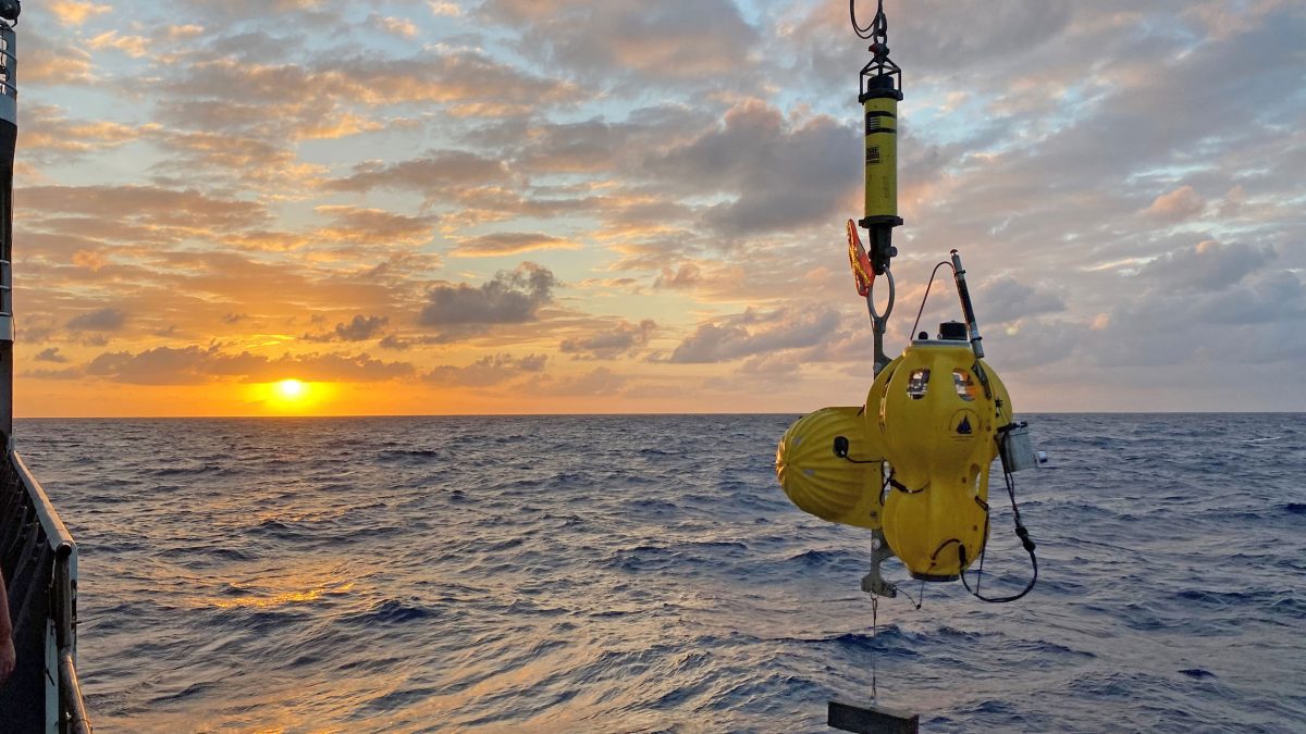 An ocean bottom seismometer being deployed by the Ocean Bottom Scismic Instrument Center during a research expedition to the Gofar transform fault in the Pacific Ocean. (Photo by Hannah Brewer, © Woods Hole Oceanographic Institution)
 May 14, 2026
Woods Hole, Mass. (May 14, 2026)—Deep beneath the eastern Pacific Ocean, about 1,000 miles off the coast of Ecuador, a fault line on the seafloor has been generating magnitude 6 earthquakes with almost clocklike regularity for at least three decades. The earthquakes strike every five to six years, in nearly the same places, at nearly the same size.
That kind of predictability is almost unheard of in earthquake science. And for years, researchers have known the pattern existed without fully understanding why.
Now they do. In a new study published in the journal Science, scientists reveal the physical mechanism behind this remarkable behavior. The answer, it turns out, lies in a pair of unusual zones within the fault itself, zones that act like built-in brakes on earthquake magnitude.
“We’ve known these barriers existed for a long time, but the question has always been, what are they made of, and why do they keep stopping earthquakes so reliably, cycle after cycle?” said seismologist Jianhua Gong, lead author of the study and Assistant Professor of Earth and Atmospheric Sciences in the College of Arts and Sciences at Indiana University Bloomington.
Professor Gong, with colleagues from the Woods Hole Oceanographic Institution (WHOI), Scripps Institution of Oceanography at UC San Diego, the U.S. Geological Survey, Boston College, the University of Delaware, Western Washington University, the University of New Hampshire, and McGill University, studied the Gofar transform fault, which sits along the East Pacific Rise off of the west coast of Ecuador, aiming to solve a 30-year mystery about why certain underwater faults produce large earthquakes like clockwork.
The Gofar fault is a long underwater trough where the Pacific and Nazca tectonic plates, two of the massive slabs of rock that make up Earth’s outer shell, grind past each other at a rate of about 140 millimeters per year, roughly the speed a fingernail grows. Transform faults are the boundaries where plates slide horizontally past each other, and the Gofar fault is one of the most studied of its kind anywhere on Earth’s seafloor.
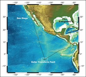
The Gofar transform fault is situated along the East Pacific Rise west of Ecuador. This image displays the cruise track from from a 2021 expedition aboard the research vessel Thomas G. Thompson to Gofar that to recover and redeploy ocean bottom seismographs that set tail from San Diego and ended in Port Everglades, Florida. (Image courtesy of Emily Roland, Western Washington Uniersity)
What makes Gofar unusual is that its large earthquakes happen repeatedly in the same spots, and they stop at the same spots. Between those earthquake zones lie stretches of fault that seem to absorb stress quietly, without producing major quakes. Scientists call these stretches “barriers.” But until now, nobody could fully explain what made them work.
To find out, the research team drew on data from two major ocean-floor experiments, one conducted in 2008 and another that ran from 2019 to 2022, in which scientists lowered instruments known as ocean bottom seismometers, which are earthquake detectors placed directly on the seafloor, along two separate segments of the Gofar fault. The instruments recorded tens of thousands of tiny earthquakes in the weeks and months surrounding two major magnitude 6 events, building an extraordinarily detailed picture of how the fault behaves before, during, and after a large rupture.
What the scientists found in both barrier zones was strikingly similar. In the days and weeks before each major earthquake, the barriers lit up with intense small-earthquake activity, then went almost completely quiet immediately after the big event struck. That pattern, repeated across two different fault segments 12 years apart, pointed to a common physical mechanism at work.
The barriers, the team concluded, are not simply inert stretches of rock. They are structurally complex zones where the fault splits into multiple strands, with small sideways offsets of 100 to 400 meters between them, creating areas of local extension, like a slight gap in an otherwise continuous crack.
That geometry, combined with evidence of seawater seeping deep into the fault, promotes a process scientists call “dilatancy strengthening;” that is, when a large earthquake rupture arrives at the barrier, the sudden movement causes the porous, fluid-saturated rock to momentarily lock up, as pore pressure, which is the pressure of fluids trapped inside the rock and opposing the rock's confining pressure, drops sharply, effectively slamming the brakes on the rupture before it can grow larger.
“These barriers are not just passive features of the landscape,” said Gong, who was a graduate student in the MIT-WHOI Joint Program during part of the research. “They are active, dynamic parts of the fault system, and understanding how they work changes how we think about earthquake limits on these faults.”
The Gofar fault sits far from populated coastlines, so its earthquakes pose little direct hazard to people. But the findings carry implications well beyond this one remote fault system.
Transform faults like Gofar exist all over the world’s ocean floors, and they are responsible for a puzzling feature that scientists have long noted in global earthquake records. Large underwater earthquakes tend to stay smaller than geologic conditions would seem to allow, as if some feature or process consistently puts a ceiling on their size.
The new findings suggest that barrier zones like the ones at Gofar, formed by the same combination of complex fault geometry and seawater infiltration, may be widespread across the ocean floor, acting as a global system of natural brakes that limit the maximum size of earthquakes along these boundaries.
That insight could help improve earthquake models used to assess seismic risk along underwater faults worldwide, including those near coastal population centers.
The research was funded by the U.S. National Science Foundation and the Natural Sciences and Engineering Research Council of Canada.
###
About Woods Hole Oceanographic Institution
Woods Hole Oceanographic Institution (WHOI) is a private, non-profit organization on Cape Cod, Massachusetts, dedicated to marine research, engineering, and higher education. Founded in 1930, its mission is to understand the ocean, its interactions with the Earth, and its role in a changing global environment. WHOI’s pioneering discoveries arise from a unique blend of science and engineering that has made it one of the world’s most trusted leaders in ocean research and exploration. Known for its multidisciplinary approach, advanced ship operations, and unmatched deep-sea robotics, WHOI also operates the most extensive suite of ocean data-gathering platforms worldwide. More than 800 concurrent projects—driven by top scientists, engineers, and students—push the boundaries of knowledge to inform people and policy for a healthier planet. Behind the scenes, ship captains, mates, craftsmen, marine operations, and other skilled professionals provide essential support that makes this work possible. Learn more at whoi.edu.
Key Takeaways
- Scientists discovered that unique "barrier zones" on the Gofar fault in the South Pacific prevent large underwater earthquakes from growing beyond a certain size.
- The Gofar fault's earthquakes occur with surprising regularity, every five to six years, due in part to these active geological barriers.
- Findings may help improve global earthquake models, shedding light on why underwater quakes often remain smaller than expected.