
Biló, T., Straneo, F., Holte, J., & Le Bras, I., 2022. Arrival of new Great Salinity Anomaly weakens convection in the Irminger Sea. Geophysical Research Letters, 49(11). https://doi.org/10.1029/2022gl098857
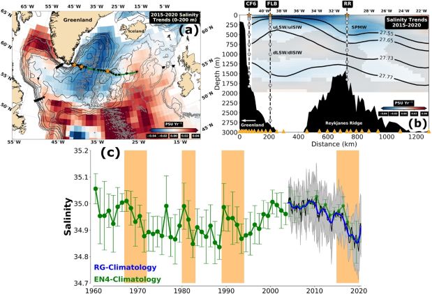
Figure provided by Isabela Le Bras
Salinity trends and time series in the Irminger Sea. (a) 2015–2020 salinity trends averaged in the upper 200 m and (b) 2015–2020 salinity trends at the Overturning in the Subpolar North Atlantic Program (OSNAP) East array (i.e., solid green line in (a)) from the Roemmich and Gilson-climatology. The triangles indicate the OSNAP and Ocean Observatories Initiative (OOI) moorings locations in the Subpolar North Atlantic (SPNA), and the stars highlight the CF6, FLB, and RR moorings. Gray lines in (a) are the 1,000, 2,000, and 3,000 m isobaths, while black lines represent 2015–2020 mean absolute dynamic topography isolines (or geostrophic stream function) from AVISO equally spaced in 0.05 m between −0.65 and −0.35 m. Gray circles and solid lines in (b) are the pointwise CTD locations on the highlighted moorings, and the 2015–2020 mean potential density (σθ) surfaces in kg m−3, respectively. Shaded areas show where the salinity trends are not statistically significant at the 95% confidence level. (c) Annual and 18-month low-passed filtered time series of the average salinity within the Irminger Sea’s upper 200 m depth from EN4 (solid green line) and RG (solid blue line) climatologies, respectively. The thin black line is the RG-climatology monthly salinity values. Uncertainties represent the 95% confidence interval of the EN4 annual averages (green dots) and the Argo monthly averages (shaded gray areas). Finally, orange highlighted periods show the 1960s–1970s, 1980s, 1990s, and the most recent (i.e., 2015–2020) hypothesized Great Salinity Anomalies in the SPNA. Salinity units are practical salinity units. Acronyms and abbreviations: RR, Reykjanes Ridge; uLSW, upper Labrador Sea Water; dLSW, deep Labrador Sea Water; uISIW, upper Irminger Sea Intermediate Water; dISIW, deep Irminger Sea Intermediate Water; SPMW, Subpolar Mode Water.