
August 27, 2011While I hate to admit it, some landscapes are so spectacular that they’re revealed more evocatively by photography than by language. The east coast of Greenland is one. However, yesterday morning it appeared that neither would be efficacious. We steamed toward the coast in “thick o’ fog,” barely a ship’s length worth of visibility. A big iceberg appeared on radar barely a mile off the starboard bow long before its ghostly presence hove into sight. Another off the port beam remained invisible except by radar. The fog thickened.
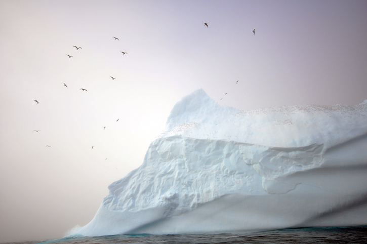
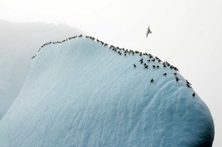
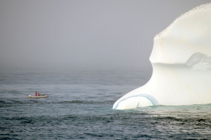
A berg the size of a Manhattan apartment building. © Rachel Fletcher “Well,” someone said with a shrug, about the third to do so, “we’ll have two more chances later in the trip.” There was scientific purpose to our close approach to Greenland, but another objective was to acquire footage for the National Geographic TV special. So the deck crew craned the RHIB over the side. Rob, Rachel, our still photographer, and Chief Mate Adam clambered aboard and sped off after the nearer iceberg to get whatever images the murk allowed. Hopeful members of the science staff and off-duty crew stood around the maindeck cameras in hand, but disappointment was beginning to sink in. The Skip brought Knorr to a stop, waiting. A glint of sun revealed a patch of blue overhead. “It’s clearing!” No, ten minutes later the woolly fog closed the hole. “Knorr. Avon,” Adam called on the radio. (Avon is the manufacturer of the RHIB, and so it became the call sign.) “Go ahead, Adam,” said the Skip. “Rob wants you to bring the ship over so he can shoot her against the berg.” “Okay, Adam.” He turned to me, hanging around on the bridge. “You want to drive?” “Sure,” I said. “Oh, god,” said my “friend,” Pete the chief engineer. (Pete’s Polish; we call him “Chiefski.” Among other things.) “Now, you see that berg, right?” “The big white thing?” “Right. Don’t hit it.” “Steer one-five-zero,” said the Skip. “One-five-zero.” There were other “witty” bits of irony. “Close all water-tight doors,” somebody said, but I ignored the rabble. Peasants. The berg, about the size of a Midtown Manhattan apartment building, took form as we drew nearer, hundreds of birds perched on it crest. “Avon. Knorr. What’s Rob want us to do?” “Circle the berg,” Adam replied.
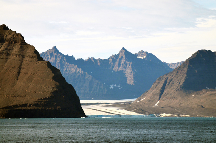
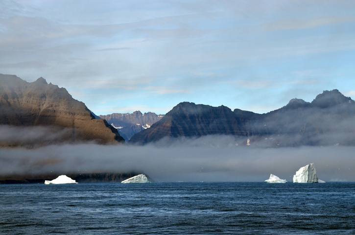
This was an old berg—they can drift around for decades, depending on the currents, but most East Greenland icebergs are sent south into the shipping lanes by the East Greenland Current—veined with cross-hatched strips of blue ice and evidence of previous waterlines formed when its center of buoyancy changed as it melted. (See photos, better than words.) You don’t want to approach too close to these things lest you get swamped when they calve. While we were waiting, the CTD crew did another cast. I’ve been waiting to discuss the CTD, its purpose and mode of deployment until after the mooring ops are complete. Suffice it to say for now that this elaborate device, fundamental to physical oceanography, measures temperature, salinity, and current velocity. That’s essentially the same kind of data collected by moorings, but with the major difference that the CTD is portable. Once the mooring operations are complete, the techs and two members of the science staff will leave the ship in northern Iceland. Then Bob and Kjetil—using the CTD as their main tool—will lead us in that search of the headwaters of the North Icelandic Jet. We’ll talk CTDs at that point. “Look! It’s clearing.” Come on, we’d heard that be— No, this time it really was clearing. We could see clearly now that magnificent coastline off the port side. Enough watchers and photographers scurried to that side to induce a port list. Thousand-meter, saw-toothed, naked-rock cliffs skirted by scree fields soared vertically from sea level. Horizontal wisps of fog, as if called up for the sake of drama, hung in the air halfway up the mountain while waves broke around its base. Layers of pointed peaks one higher than the last stepped inland toward the great Greenland Ice Sheet, a scene of wonder and that otherwise over-used word awe. New sun glinted magically on the icebergs. You have to remind yourself that the East Greenland coast is real, not the product of some scene painter’s over-caffeinated imagination. If I turn away, will it still be there when I look back?
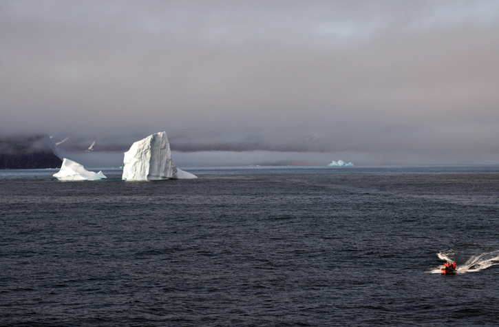
This was Cape Tupinier (68°40’ North by 26°20’ West) on the Blosseville Coast, a couple of hundred miles south of Scoresby Sound (Kangertittuaq, in Greenlandic), the largest fjord in the world. There remain few unexplored places on Earth, but the Blosseville coast may well be one. Here there is almost no flat land if you don’t count glaciers coursing down to the sea from the Ice Sheet, nothing to sustain human travel—or life. Not even the Inuit come here. The skip called the Avon back to the ship to change crews. Laura wanted to grab a sample of inshore water. She’s studying the East Greenland Current (EGC) flowing southward out of the High Arctic along the shelf into the Denmark Strait. The EGC contains a relatively high quantity of freshwater, runoff from the Ice Sheet and other sources, and by repeatedly measuring its oxygen isotopes, she can begin to determine whether or not the freshwater content is increasing. Too much freshwater on the surface will inhibit the vital convection (sinking) that occurs north of the Denmark Strait. However, no one is yet certain how much freshwater is “too much.”
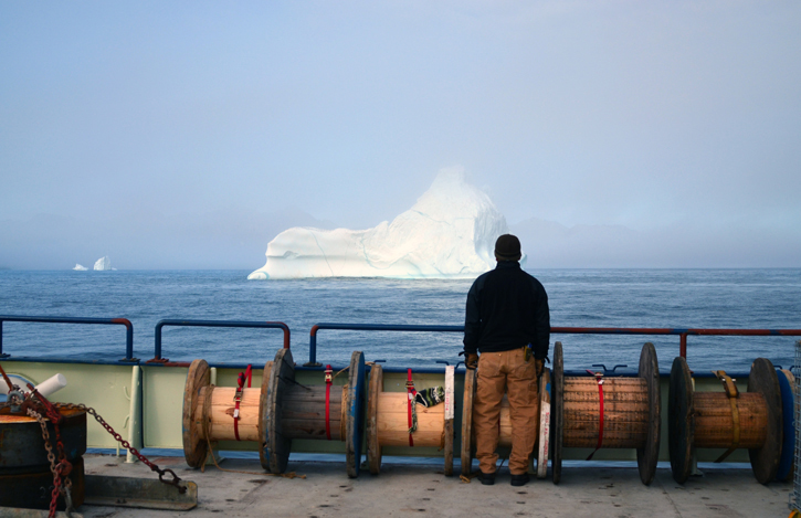
Avon and the berg. © Rachel Fletcher The Avon headed back toward the coast and soon disappeared behind a line of bergs close enough to the shore to be aground. The plan, for photography’s sake, was for us to bring Knorr as close inshore as the Skip dared. He took back the helm—“I might have to take evasive maneuvers.” We proceeded toward the cliffs at two knots, eyes on the fathometer—it never climbed above 65 meters—to within a couple of miles of the “beach.” We searched for the boat with binoculars. The radar wasn’t of much use with so many targets in the water. “Avon. Knorr. Where are you, Adam?” “Between the set of bergs on your right.” “Okay, we have you.” The Skip parked his ship in a photogenic position. And from there we ogled the magnificence for the next two hours until, inevitably, we had to get underway for the final three mooring sites. Too soon Greenland vanished. Maybe it was never there. “Well, we’ll have two more chances.”
Last updated: December 27, 2011 | ||||||||||||||||||||
Copyright ©2007 Woods Hole Oceanographic Institution, All Rights Reserved, Privacy Policy. | ||||||||||||||||||||