How to study an underwater earthquake from shore
Lessons from a successful hybrid Sentry expedition
Estimated reading time: 6 minutes
A prediction and a problem
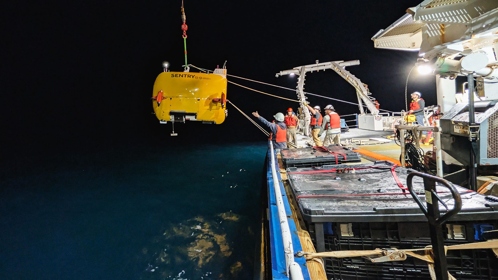
A magnitude 6 earthquake along the Gofar Transform Fault in the eastern Pacific Ocean shook the seafloor in April 2020, just when a WHOI-based science team predicted. Fortunately, they had seeded the area with ocean-bottom seismometers to record it only a few months before. All that was left was to go back to collect the data and map the area with Autonomous Underwater Vehicle Sentry. The only problem: it was early in the COVID-19 pandemic and all U.S. research cruises were paused.
Predicting the timing of an earthquake at an underwater transform fault is a new avenue of research in the field of plate tectonics, says WHOI Geochemist Chris German, who is a co-PI on the 4CAST GOFAR project, funded by the National Science Foundation.
A transform fault forms where two plates move past each other, and quake predictions are based, in part, on the rate of movement between the two plates. The San Andreas fault, running north through San Francisco, California, is one of the better-known on-land transform faults. Under the sea, they don’t always get the same attention as volcanic mid-ocean ridges or deep trenches. But when two plates sliding past each other don’t move smoothly and get hung up, large magnitude earthquakes can result.
After the quake at the Gofar fault, the follow up cruises had to be restructured because of the pandemic. The second cruise became a rescue mission just to switch out seismometers. Much of the additional proposed work got pushed to the final cruise. But when that time came, long quarantines and the need to fit two cruises’ worth of survey equipment on board made it impossible to get the whole team out to sea. So, for the final cruise, Sentry dives were coordinated from shore at Woods Hole Oceanographic Institution (WHOI).
Sentry is an autonomous vehicle with pre-programmed routes, but most dives are planned on the ship, with the science team working directly with Sentry’s engineers to review data from the most recent dives and fine tune the plan for the next one. Planning from shore is not typical. This expedition represented a new hybrid model for dive planning, with the vehicle team at sea and the science team on shore. Here’s how they made it work:
1. Establish a home base
For dive planning sessions, science team members who could not go to sea came to Woods Hole to work in the social hub room at WHOI’s new George and Wendy David Center for Ocean Innovation. The space has monitors to display data, cameras for meeting virtually with offsite team members, and computers which the Sentry Team configured to keep the science team connected to what was happening at sea.


2. Have vehicle staff on shore and on the ship
“You need an expedition leader who understands the vehicle on shore as well as on the ship,” says German. For this cruise, members of the Sentry Operations Team met with the scientists in person each day to make sure that requests sent to Zac Berkowitz, the expedition leader at sea, made sense. The daily discussion of goals for the next dive is a really valuable part of time at sea, German adds. “An expedition leader helps you come up with a better mission plan because they do this all the time. It really helps to have someone with that status here on shore, who can actually spot if we’re about to ask for something stupid.”
3. Set up real-time monitoring
“The first thing we did was set up a display of Sentry’s underwater location,” says German. While this sounds simple, it was no small feat to get real-time location maps from a research vessel that had limited bandwidth. To do so, the Sentry Team sent their binary data to shore where they generated the same plots that were being used at sea. “With almost no latency, we could see on a computer at AVAST, exactly what the people on the ship were seeing," says German. "This immediately gave us visual cues such as how much data was going to be collected during each dive, before each mission ended, and what we should prioritize for the next dive.”
4. Choose communication times that work for everyone
Sentry was operating from a ship in the eastern Pacific Ocean, there was a collaborator in Australia, another in Seattle, and a team in Woods Hole. For a group spanning this many time zones, the science team had to prepare a dive plan and email to Berkowitz, the at-sea expedition leader, before he woke up each day. While the science team had the benefit of in-person and video conferencing, the Sentry Team at sea didn't. Sending a written copy of what was being requested proved the most effective way to communicate with the ship. It also gave Berkowitz and the Sentry Team time to read it through on their own time, when they had a chance to breathe.
5. Don’t forget what it is like to actually be at sea
Some things are just harder to discern when you are making requests from shore. “When you are at sea, you know what the weather's like, for example,” says German. “You know if everybody is getting tired and you know when to tread gently. And you know how to approach people and have face-to-face conversations. It's very hard to convey any of that kind of nuance through the written word of an email.”
What’s next?
“We did this because of COVID limitations, but now we have the ability for people to see what a vehicle is doing in real time, from shore," says German. "And we also worked on putting a pipeline in place so that we could even get some of the data from the vehicle in real time—straight from the seafloor to AVAST across thousands of meters of ocean to the ship, thousands of kilometers to a satellite, and from there to WHOI.”
Hybrid cruises will enable greater inclusion in deep sea science, says Anna Michel, WHOI’s Chief Scientist for the National Deep Submergence Facility. “Increasing access to expeditions is a major goal for me as chief scientist. There are many reasons why scientists and engineers may be unable to participate physically on the cruise itself—such as care-giving responsibilities, berthing constraints, medical reasons, or teaching obligations. By enabling remote participation, we can involve a larger, more diverse team.”
In addition to allowing those who cannot travel to sea to participate in deep sea science, German adds, this technology will also help with mission planning in places where humans cannot presently voyage at all—like to the oceans on other planets.
4CAST GOFAR is funded by the National Science Foundation. In addition to Chris German, the on-shore team included: Margaret Boettcher, lead PI for the 3-cruise project and University of New Hampshire assistant professor; Emily Roland, project co-PI, science lead for the expedition, and Western Washington University assistant professor; Jessica Warren, project co-PI and University of Delaware associate professor and Mindy Bahruth, University of Delaware PhD student. From the Sentry Team Sean Kelley, Matt Silvia, and Stefano Suman assisted with on-shore planning.
MEET THE AUTHOR Hannah Piecuch
Hannah Piecuch is a staff writer for Oceanus magazine and a designer in WHOI’s Creative Studio. As both a writer and designer, she has a comprehensive...
Read more