Unique Vehicles for a Unique Environment
New autonomous robots will pierce an ice-covered ocean and explore the Arctic abyss
Imagine you have inherited a magnificent medieval castle. You wander its corridors, climbing spiral staircases to hidden towers, delving purposefully into subterranean caverns, and delighting in the details of its architecture, history, and artistic treasures. Over time you come to realize there is a great North Wing that has long been sealed off from the rest of the castle.
You’ve found old documents in the library describing construction of the North Wing, and it appears as though it was built using rare materials that are not found anywhere else in the castle. As best as you can tell the castle’s main thermostat is inside the North Wing, which adds some urgency because lately the castle seems to be getting inexplicably warmer. And, perhaps most intriguing, recent evidence suggests that something—perhaps even something unusual—might actually be living in there.
Even so, it might be more accurate to confess that you’ve just got to gain entrance to the North Wing—because not being able to enter rooms in your own house is unbearable.
Finding a way in
You come to realize, however, that you’re not the first to try. Numerous intrepid individuals have dedicated themselves to the pursuit over the years, their stories comprising a veritable tome of frustration and failure. And why? Because the North Wing is hidden under a moat of water more than two miles deep, which, in turn, is covered by a permanent layer of ice.
Moreover, it is so far north that the compasses and gyroscopes typically used for navigation are essentially useless. The tools required to get through ice and into the abyss to explore the North Wing cannot be bought at any price. You will have to make them yourself.
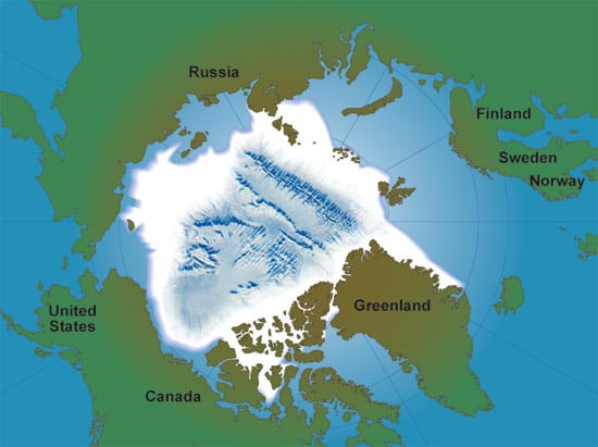
You have probably guessed by now that the castle in this mental exercise is Earth, and the North Wing is the vast, ice-covered Arctic Ocean Basin. If the old adage is true that we know more about the surface of our neighboring planets than we do about Earth’s ocean basins (and it is), then nowhere is it more true than the Arctic Basin.
A blank spot on the map of Earth
Deep-sea research is hard enough as it is. But cover the ocean you’re trying to explore with a permanent ice cap, limit your available field season to a few months that are not too cold and dark, and factor in a generally inaccessible location at the very top of the world, and you can begin to appreciate why we know so little about the Arctic Basin.
In fact, were it not for a few Russian and American scientists whiling the months away in camps on drifting ice floes, we would know almost nothing at all about the earth’s great North Wing. (Actually, U.S. and Soviet navies also gathered data about the Arctic during the heyday of Cold War submarine warfare, but this information is generally classified.)
The human spirit cannot abide a puzzle with a missing piece. But this is especially so when the missing piece could fill in crucial details about the origin of Earth’s oceans, the evolution of life, and our planet’s susceptibility to climate change.
An unexplored frontier
For climatologists and physical oceanographers, it is often said that the Arctic is a canary in the environmental coal mine. In a warming world, the Arctic’s delicately balanced ocean circulation and sea ice appears vulnerable to disruptions that could have dramatic impacts on Earth’s oceans and climate. Thus, climate change drives a large percentage of Arctic research.
But the Arctic Basin is so unknown and unique, it probably holds more undiscovered scientific treasures than any other ocean basin on Earth. Perhaps the hardest challenge is deciding which fundamental scientific questions to attack first.
For marine biologists, for example, the Arctic represents a potential gold mine. About 65 million years ago, the Arctic Ocean basin became enclosed, with no deepwater connections to any other ocean basin on Earth. Species and biological communities in the Arctic Ocean may have developed and evolved in isolation, possibly making the Arctic a sort of marine equivalent of Australia. (See The Evolutionary Puzzle of Seafloor Life).
A 21st-century voyage of discovery
In 2001, Woods Hole Oceanographic Institution (WHOI) scientist Henry Dick was part of a team that conducted the most detailed exploration to date of the Gakkel Ridge, which transects the eastern Arctic Basin and is perhaps the most enigmatic tectonic plate boundary on Earth. Like all mid-ocean ridges, the Gakkel Ridge is an undersea volcanic mountain chain where magma erupts to create new ocean crust that spreads out on both sides of the ridge. It was thought to be spreading so slowly, however, that it would have little volcanic and hydrothermal activity on it.
But Dick and colleagues found tantalizing clues of active volcanism and ubiquitous hydrothermal venting on the Gakkel Ridge. What’s more, they gathered evidence that seafloor spreading on the Gakkel Ridge occurs in a fundamentally different way compared to other previously explored ridges. (See Earth’s Complex Complexion)
Dick and colleagues recovered rocks from the Gakkel Ridge composed of materials that normally reside in the mantle deep within Earth’s interior, and that are rarely found on Earth’s surface. These rocks are perhaps the closest modern analogues to the kind of volcanic rocks that erupted billions of years ago in the early stages of Earth’s history. They have a distinct chemistry that affects their interaction with seawater circulating through hydrothermal vent systems. (See The Remarkable Diversity of Seafloor Vents) These chemical reactions release exceptionally large amounts of chemical “food” for the kinds of evolutionarily ancient microbes that reside at the roots of the Tree of Life. (See Is Life Thriving Deep Beneath the Seafloor?) The hydrothermal vent fields on the Gakkel Ridge could therefore provide a means to study hydrothermal activity on an early Earth, and possibly even provide clues to the origin of life on this planet.
Many questions, little data
Scientists only began to get their first detailed look at the Arctic seafloor between 1995 and 1999, when the U.S. Navy and the National Science Foundation (NSF) teamed up to use Navy nuclear submarines for unclassified scientific investigations.
We still have almost no data from most of the mountain chains in the Arctic Basin, so we’re still guessing about their composition, age, and origin. Yet, the sparse evidence we do have suggests that the Arctic Basin did not form the same way other ocean basins did, and that it may have the oldest extant ocean crust in the world.
That’s why we dream about retrieving data from beneath the Arctic ice cap, and why we have begun to harness 21st-century technology to make those dreams come true. Nuclear subs are far too expensive to build and operate, and besides, they are crushed like tin cans at full Arctic seafloor depths. Instead, in our quaint New England village of Woods Hole, we are developing autonomous underwater vehicles (AUVs) and other advanced deep-submergence technologies that can open up the Arctic Basin to scientific investigation.
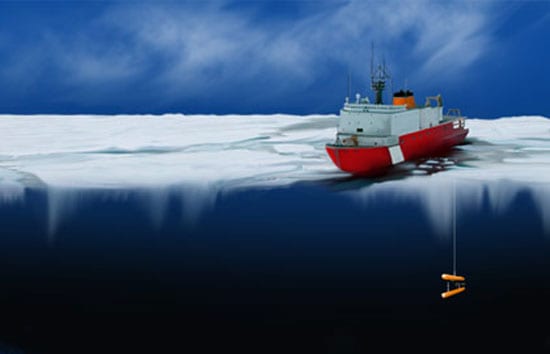
Overcoming the ice barrier
Though many scientists dream of getting beneath the ice to study the Arctic Basin, the long-standing commitment to ocean technology and instrumentation at WHOI gives scientists here the opportunity to turn dreams into reality. We formally began a program to develop AUVs specifically for under-ice operations in the Arctic in January 2000 when the NSF Office of Polar Programs awarded WHOI a grant to design, fabricate, and test a prototype vehicle called APOGEE, the Autonomous Polar Geophysical Explorer. The objective was to develop a swimming robot that can carry a variety of scientific sensors to explore the most inaccessible regions of the Arctic Basin, and that can be deployed and recovered through a small hole in the ice.
Life is easier if AUVs can simply pop up on the ocean surface for recovery, but Arctic pack ice adds complications. APOGEE was designed with critical acoustic navigation and control systems that allow it to navigate to a homing beacon, latch itself to a wire suspended from a hole in the ice, and ultimately be recovered by scientists on an icebreaker or an ice camp. Without this essential capability, an AUV in the Arctic would almost certainly be lost.
To the Arctic and beyond?
We conducted our last set of sea trials with APOGEE in 2003. Now, we have begun to build the next generation of Arctic vehicles—under a joint grant (with the University of Maryland’s Space Systems Lab) from the Astrobiology Science and Technology for Exploring Planets program of the National Aeronautics and Space Administration.
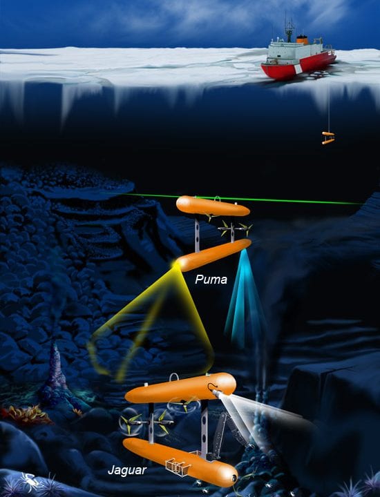
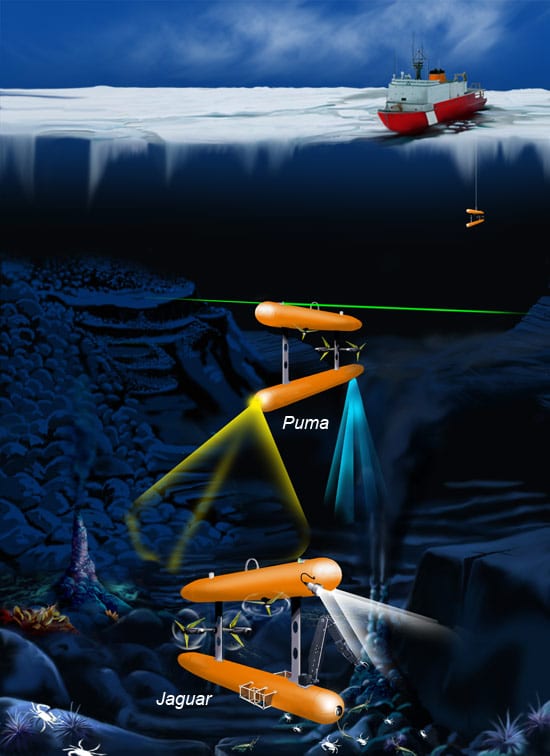
Our mission will be to use AUVs to find, map, and sample hydrothermal vent fields on the Gakkel Ridge. We will develop instrumentation that will guide future efforts to search for life on Europa, a Galilean moon of Jupiter, which may have two necessary ingredients for life: active volcanism and an ocean—albeit an ice-covered one.
The mission will also allow us to study Arctic vent fields for the first time. We will use a small group of purpose-built AUVs, each with different characteristics and equipped with state-of-the-art sensor systems. They will work in concert to study Arctic vent fields. For example, a “bloodhound” AUV (named Puma, for Plume Mapper) will be equipped with sensors that can detect tiny telltale temperature, chemical, or turbidity signals in the water. It will survey a wide area to “sniff out” one of the hydrothermal vent plumes that Henry Dick got whiffs of in 2001 and follow it back to its vent field source on the seafloor.
Once a vent is found, “hummingbird” AUVs (named Jaguar), will be deployed. These will be able to hover in place, and equipped with camera and lighting systems, high-resolution sonar, and a manipulator arm with storage canisters, they will be used for mapping, imaging, and sampling at vent sites.
Fully autonomous methods have never been used to find and image, not to mention obtain samples from, vent fields in any ocean, not to mention an ice-covered one. The technical challenges are serious and legion, but they are worthy of a cutting-edge oceanographic institution such as WHOI. We are of necessity drawing on the expertise, inspiration, and creativity of dozens of experts hailing from every department within the institution.
There is no denying that we are attempting an ambitious project that faces stiff technical challenges, but this energizes and motivates us. Ultimately, we will succeed or fail based on the talent and dedication of the scientists, engineers, and technicians who are conceiving, designing, and fabricating the new instrumentation we will take to the Arctic. Anyone who knows the people on our team would be reluctant to bet against us.
Slideshow